


June 16: Humboldt County
Devil’s Gate to the mouth of the Mattole 8.9 miles
At 9 AM we arrived back at Devils Gate and met our guide for the day. Bill McKenzie, an accountant from Eureka, started off by giving us a choice between road walking along the Mattole Road or beach waking. We split into two groups -most on the road with Bill, and a smaller number taking to the beach. Those of us who were on the beach were there because we prefer it. But another factor was an antagonistic discussion between the upland property owner and Mel the day before. Should it have come to it, we wanted to make sure that everyone understood that we were walking on the wet sands of our beach. As the two groups walked parallel to each other, it brought to mind Lee Otter’s eloquent discussion of the trail as braided strands: sometimes all the threads of the braid are closely interconnected; sometimes, like now, the strands follow different routes.
At McNutt Creek Gulch, the Mattole Road veers inland towards the little town of Petrolia, and a public access point allowed the two groups to come together. The braid now was tightly woven.
For the most part, the beach in this area is flanked by offshore rocks which were exposed by the day’s lower low tide. They provided an excellent opportunity for tide pool exploring and meant that the beach was rich in sea shells. For the first time on the trip, we found sea urchin shells as well as the internal shell plates from gum boot chitins.
All day we had a strong wind at our backs. Even with the wind going with us, the constant exposure was tiring. At lunch we all took shelter in a small driftwood-strewn, dry sandy wash. Out of the wind, the sun was very strong and the warmth was soothing to the soul, giving hope for the afternoon.
Soon we passed the mouth of Peter B Gulch. I like to think it was named for a Seattle luthier who is making a cello for his mother. Out ahead of us, we could see weather forming over Punto Gordo. As the wind forced itself onshore and started to rise, a band of fog formed and streamed over the mountains of the King Range.
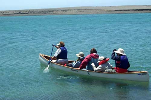
Quickly we arrived at the mouth of the Mattole River. Late rains have kept it flowing so there was no sand bar at the mouth, and the flow was fairly strong so it would have been dangerous to wade across, especially for the lighter and shorter members. But we had Berti Welty and Jo Weisgerber from Arcata, who used their canoe to make many trips across Mattole’s lagoon. When all of us had crossed, we boarded the Melmobile for the ride back to A.W. Way Park where the sun shone brightly, the wind rustled the leaves only, and the Mattole offered up wonderful deep and cool swimming holes! Our canoe captains changed roles, and soon they had cooked us a fine barbequed dinner. (Jon Breyfogle; photos, Linda Hanes, Jon Brefogle)