
Usage Notes

Legend: For details on the icons and trail colors, please click the legend icon on the map above.

Layers: Other layers are available. See the California Coastal Commission and Coastal Conservancy Completed Sections layer for the official completed trail segments. (About progress on the trail completion project.)
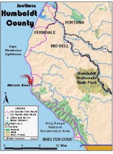
Humboldt Section 12
Creek at Steamboat Rock to Mattole River
Finally after nearly 25 miles of road walking away from the coast, CCT returns to the shore in dramatic fashion just south of Cape Mendocino, westernmost point in California. Although the Mattole Road stays within sight of the shore, you'll hardly notice the road as you walk the beach, your eyes diverted by the rugged grandeur of this wild meeting of land and sea. After a short jog up to the road before one mile, CCT returns to the beach where you can walk the tideline south all the way to the Mattole River mouth around 9 miles. However, through-hikers will want to confirm that they can ford the river when they get there, something not easy to do without sending someone to scout the ford. Try calling BLM to ask if the river's currently shallow enough to ford near its mouth, but there's no guarantee they'll have the answer. You're less likely to see other hikers on this CCT section than on the popular wilderness Lost Coast just ahead.
Walk from the north end of the highway bridge down the rocky banks of the unnamed creek. When you reach the mouth of the creek before ⅛ mile, turn south along the tideline. If you want to explore the coast north, given a moderately low tide you can walk north 1⅝ miles to Cape Mendocino where a large colony of sea lions lives. Give these immense marine mammals plenty of room. Beyond the sea lion colony you can easily walk the beach north to the mouth of Bear River at 4½ miles, but carefully time your trip so you don't get trapped by the rising tide on your return.
Heading southeast from the unnamed creek you walk a narrowing beach of fine dark sand with landmark Steamboat Rock about ⅜ mile offshore and many smaller rocks beyond the surf. The grandeur of this wild coast is breathtaking with a verdant ridge towering 1000 feet overhead to the east. When it's clear, you can see Punta Gorda 11 miles south with the most dramatic views north to looming Cape Ridge and towering Sugarloaf Island which rises 323 feet just offshore from Cape Mendocino.
You ford a seasonal creek around ½ mile. Continue southeast along the beach with the road to your east now shored up by rip-rap. At high tide you may be forced to leave the beach before Durr Creek around ¾ mile, but at moderate tides you can usually walk the beach to the big sea stacks at Devils Gate at ⅞ mile. There you must climb to the road on a path east of the rock outcrops with brief boulder hopping to reach the road. High bluffs rise steeply east of the road. Walk the road shoulder briefly to a path that drops to the beach at a broad sandy flat bordered by tidepools, a good place to camp if you're through-hiking. You can again follow the beach south at least a mile. At a point around 2 miles where low Devils Gate Rock lies almost a mile offshore, the beach narrows to a thin strip inundated at tides higher than 3.0 feet. Walk the beach or the road until the beach again broadens beyond a seasonal creek at 2⅛ miles. Then it's an easy stroll on a broad beach, fording Davis Creek at 2⅞ miles, an unnamed creek at 3⅝ miles, then Domingo Creek at 4 miles.
Continue south to cross a small seasonal creek at 4⅛ miles. The next ford beyond +¾ miles crosses McNutt Gulch Creek, the largest stream since Singley Creek. McNutt Gulch offers the last chance to return to Mattole Road before the questionable Mattole River ford. Mattole Road heads inland up McNutt Gulch to the small town of Petrolia, source of the only services for miles - store, cafe, phone, lodging. To reach the road just south of McNutt Gulch, look for two tall poles in the fence by the road. They mark the public path, with most of the remaining land up from the tideline private property.
To walk the beach south from McNutt Gulch, stay along the tideline, avoiding the private ranch property up from the beach. You also should be certain you can cross the Mattole River at its mouth, unless you are day hiking and plan to hike back north. The river is usually easy to ford from midsummer until the first big rainstorms of autumn. Sometimes a sand bar even closes off the Mattole's mouth during those months. Be forewarned that the river can rise rapidly after rainstorms of an inch or more.
The beach south of McNutt Gulch is extremely broad with low dunes to the east. By 5⅜ miles you come to Mussel Rock where a sandy point overlooks mussel beds along the low tideline. Several shell middens in the dunes indicate that this was a food gathering spot for the Mattole tribe that lived in this area. Walk south from the point along the broad beach. At 6½ miles you pass a . seasonal stream that only flows under the sand in the dry season. The beach narrows suddenly with dunes stacked against the bluffs. Continue south along the narrow beach unless a very high tide delays your progress. By 7⅛ miles you pass Hair Seal Rock directly offshore. Follow the narrow strand south to the mouth of Peter B. Gulch at 7⅜ miles. The beach becomes broad again at this pleasant spot where there might be room to camp just above the tideline with the high bluffs to the north providing shelter from the wind.
As you follow the beach south, it remains broad until an unnamed gully at 8 miles. Then the beach narrows along the base of high cliffs descending from Moore Hill and Collins Point. You pass Sea Lion Rock offshore. The beach broadens again as you approach Mattole Point at 8⅝ miles.
Continue along the tideline to the Mattole River mouth. While it is mapped as only ¼ mile south of Mattole Point, the position of the mouth may change from year to year. Be certain you can ford the river safely before proceeding. A local resident who had lived her entire life in the area was swept out to sea and drowned a few years ago when she underestimated the river's power.
After the ford it's a short stroll along the beach to the Mattole River Recreation Site at 9⅝ miles, starting point for the famous Lost Coast portion of the Coastal Trail.
ALTERNATE ROUTE: When the tides are too high to walk the beach, or the river is too deep and fast to ford, through-hikers can walk Mattole Road through Petrolia (11 miles from access point), then walk Lighthouse Road 5 miles to its end.
SUGGESTED ROUND TRIPS & LOOPS: You can take pleasant day hikes north or south along the beach from the access point, Devil's Gate or McNutt Gulch. In fact from McNutt Gulch, this section divides nicely into two nearly equal parts.
Distance: 9⅝ miles (15.5 kilometers).
Open to: Hikers.
Surface: Beach.
Access point: Creek at Steamboat Rock.
How to get there: From the north, follow directions to Section access point, then drive Mattole Road (CCT) 19.5 miles to the second bridge after you reach the coast. From the south, follow directions for Section 13 to Lighthouse Road, then go 6.5 miles farther on Mattole Road to bridge at unnamed creek.
Other access: Devil's Gate, McNutt Gulch.
Difficulty: Easy
Elevation gain/loss: 40 feet+/40 feet-.
Cautions: The Mattole River at the south end of this section may not be fordable in winter and spring or after rains. In that case you'd have to turn around and hike back to McNutt Gulch, then follow Alternate Route.
Further information: Bureau of Land Management (707) 825-2300.
Facilities: None except chemical toilet and picnic area at south end. Phone in Petrolia.
Campgrounds: Mattole River Recreation Site at south end (no water), A. W. Way County Park 7 miles east of Petrolia on Mattole Road.
Lodging: Petrolia has Lost Inn and Ziganti's. Honeydew has Mattole River Resort.
Points of Interest
No individual points found.
In the News
Interested in contributing to this project?
Register to add new photos and information, update existing results and share your trip reports.