
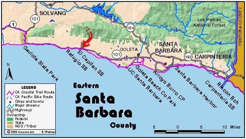

August 24: Santa Barbara County Gaviota State Park to El Capitan Beach State Park. 11.8 miles
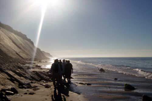
We were joined again by Mike Lunsford, retired State Parks Ranger, who acted as guide. We left Gaviota State Park under a clear sky and with very calm seas. For the first time on our journey, we were heading east, into the rising sun, having turned the corner, and now indeed are in Southern California. The geology, vegetation and warmer ocean temperature are different from what we experienced north of Point Conception.
We were walking on a day of moderate tides and started an hour or so before the high tide so that for the rest of the day the tide will be falling. This is important, for on our day’s walk we need a tide low enough, in the +2 to +3 foot range, to make it past the occasional rocky promontories that jut out into the ocean. The beach here is a narrow strip of sand with occasional boulders. At the back of the beach are tall cliffs of Monterey sandstone; sometimes tilted away from us, sometimes vertical, sometimes towards us. Geology has been very active in this area. On the beach are little globules of tar to avoid. At each rocky point, we were forced to either climb up and over the rocks or to go around in the water. We are all wearing sandals or are barefoot, we are walking on sand and not on slippery underwater rocks, and so the choice is easy: we took to the water.
Like reverse surfers, we timed our moves for the smallest waves. Then it was either a walk or a wild scramble around the point, depending on the topography and what the next wave looked like. However, it was safe enough; the surf was very gentle, the sand firm, and the waves never got above thigh high. Early on we learned that as you skirt around a rock you need to stay away from it. The wave coming in is no problem; it is the splashback after hitting the rock that soaks you head to toe. Making the day even more fun was the warmer temperature of the water. North of Point Conception this would have been a different story, with bigger waves and colder water.
So, that was how the day progressed. Beach walking and ocean wading. Along the way we encountered some concrete seawalls protecting the rail line, which we were forced to walk on because the beach was gone below them. At one point, we had to climb up to the railroad tracks and use them when we came to a no-pass point on the beach. East of Refugio cliffs from which water dripped, creating mossy stalactites, backed the beach. Here the orange-yellow sandstone was often bearded with chartreuse algae.
For those of us who walked this day (a few chose not to play in the water) it was a great deal of fun. We felt like little kids again, playing in the waves, climbing over rocks, and cobble hopping. Linda calls this day a Play Day for the CTE03. (Jon Breyfogle; photos by Linda Hanes and J Nichols)
Left: Negotiating the beach on the Gaviota Coast. Right: Walking east into the sunrise.
For trail section - Santa Barbara Section 5, Santa Barbara Section 6