
Usage Notes

Legend: For details on the icons and trail colors, please click the legend icon on the map above.

Layers: Other layers are available. See the California Coastal Commission and Coastal Conservancy Completed Sections layer for the official completed trail segments. (About progress on the trail completion project.)
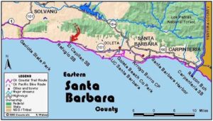
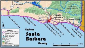
Santa Barbara Section 6
El Capitan State Park to Isla Vista
The long, tide-dependent trek along the rural western Santa Barbara coast concludes with this section which ends at the west campus of the University of California at Santa Barbara in the student town of Isla Vista. Despite some onshore oil facilities, this long trek remains essentially rural until you pass the new Bacara Resort at 7 miles. Once again you'll want to plan your hike to coincide with an appropriate low tide.
From the El Capitan Beach store by the day-use lot, take the trail down to the beach, passing a restroom in 200 feet. Turn left and walk down coast (east), either on the paved path at the base of the bluff or the tideline of the sandy beach. By ⅛ mile the paved path ends at a grassy picnic area, which extends east to the point at ¼ mile. From the start of the picnic area, an adjacent gravel path offers easier walking than the rocky tideline.
At El Capitan Point, the gravel path veers inland but you continue on a dirt path paralleling the shore. It soon crosses the usually tiny creek and passes a final chemical toilet on your left. Around ⅜ mile the path ends at a cobblestone beach.
Turn left and walk down the coast which heads north briefly from the point surrounding the creek.
By ½ mile the rocky beach ends. CCT continues along the sandy beach, which quickly turns east, heading toward Santa Barbara at the base of 100-foot cliffs. From ⅝ to ⅞ mile you parallel a seawall built to protect the railroad on the blufftop above. Before one mile you round a small point where the beach may be inundated at tides higher than +3.0 feet.
Continue east on the beach, passing Las Llagas Canyon and a path to the highway at 1½ miles, then walking a narrow beach beneath 60-foot-high bluffs. Where you pass a gully jammed with bamboo-like carrizo at 2⅛ miles, the near-white cliffs you've been following give way to fractured orange-brown bluffs.
Round a prominent point at 2⅜ miles. If the day is clear, look west for a view along 28 miles of mostly wild coast to Government Point near Point Conception. Usually when the air is that clear, you can also see the Channel Islands offshore about the same distance to the south, with Santa Cruz Island, largest of the Channel group, due south from here. Beyond the point at 2⅜ miles, you must rock hop to get down the coast. Try to stay above the slippery rocks at tideline. After you cross the mouth of Gato Canyon, a path follows the high tideline above the rocks, a reaching a sandy beach before 2⅝ miles.
Beyond 2¾ miles, where eucalyptus trees grow atop the bluffs, several small canyons allow escape to the railroad tracks in a high-tide emergency. Walk a broad beach beneath eroded bluffs. Around 3⅜ miles, only the raised landfill bed of the train tracks stands on your left. Pass the creek of Las Varas Canyon flowing from a tunnel beneath the tracks.
At 3½ miles you encounter the first of several rock ledges protruding into the tidal zone. You need a tide lower than +2.4 feet to walk the next ½ mile of shore and stay dry. The very first rock ledge offers the tightest passage, although it doesn't look like the worst from there. That ledge consists of a diagonal shelf of hardened orange sandstone extending about 40 feet from the cliff. If you can't get around its tip, you can probably scramble over its chest-high mid-section. If you cannot, you can retrace your steps about 50 feet to an emergency escape trail climbing to the train tracks. Though it would be trespassing, one could walk the tracks east, then descend across oil company property to the mouth of Dos Pueblos Canyon at 4 miles.
Assuming you get around the ledge, walk east along a secluded narrow beach strewn with medium to large rocks and crowded by golden bluffs. Cliff swallows nest on the cliffs around 3¾ miles in summer. From there you can see the broad mouth of Dos Pueblos Canyon. Walk the narrow beach east to cross the canyon's mouth at 4 miles. It's a pretty spot with oil company property upstream.
Continue east along a sandy, rock-strewn beach backed by bluffs of massive slabs of white rock. Round a tall point topped by a white pole at 4⅛ miles, gaining a coastal view east that ends at Coal Oil Point near section's end. After rounding the point at 4⅛ miles, another nearby point comes into view. This happens twice more before 5 miles. After passing these small points, you can see the prominent V of Eagle Canyon ahead with an oil company pier beyond it and Coal Oil Point extending seaward beyond.
Walk the narrow rock-strewn beach east beneath 60-foot bluffs. As you pass two small canyons at 5⅜ and 5¾ miles, you may get a glimpse of the extensive oil drilling activities hidden atop the marine terrace beyond the bluffs. This area was developed long ago for its abundant oil reserves. Fortunately most of this industrial buildup is hidden from the marvelous beach.
The bluffs reach 90 feet high and the beach once again becomes a narrow strip only passable at tides below +2.4 feet before you reach Eagle Canyon at 6¼ miles. After crossing the mouth of the canyon, you must once again navigate a narrow strip of beach at tides below +2.4 feet. If you cannot get through, you could get around it by climbing to the tracks, walking them east to the oil pier, then trespassing across oil company property to return to the tideline. Of course it's far better to time your walk with the tides, avoiding trespassing and possibility of arrest.
Continue along alternately sandy and rocky narrow beach, reaching the oil company pier at 6⅝ miles. Another 250 feet of rock hopping follows, passing the section's narrowest tidal passage at a protruding rock ledge with a natural window. Just 100 feet more of rock hopping leads finally to long sandy Haskells Beach, much broader than the strand you've followed since the 3½-mile-point.
Reach the west rim of Tecolote Canyon at 6⅞ miles. Not long ago it was a wild canyon, but at press time the massive new Bacara Resort was being built, due to open in 2000. Amidst the wetlands east of the hotel, a towering landfill rises above the natural landscape. Phase two of this controversial development would include tennis courts built on this huge fill pile. The sight of this immense commercial development after one has walked all these miles of pristine shoreline leads one to ponder. Will the current fate of Tecolote Canyon be the eventual fate of too many other Santa Barbara coastal canyons?
Reach the canyon's east rim in 300 feet, where a dirt road currently provides public access to the beach. Walk the beach beneath 100-foot bluffs topped with giant eucalyptus trees to Bell Canyon at 7⅛ miles. Walk the strand below the mouth of this broad canyon, first passing undisturbed wetlands, then paralleling the lush green of a golf course until 7⅜ miles where the canyon ends and the golf links climb onto the terrace above the bluff.
Walk the beach beneath 40-foot bluffs where prickly pear cacti have naturalized, paralleling an old oil company service road along the base of the bluffs. It soon leads to another short oil company pier, perhaps linked more than aesthetically with the abandoned drilling platform visible ¼ mile offshore, not to mention the slightly less obtrusive active rig farther offshore.
Walk this otherwise pleasant beach east toward Coal Oil Point, once again in view across the waves. Along the base of the bluff you'll notice the ruins of a wooden retaining wall which once supported an extension of the oil company road. Pass wild bluffs towering 100 feet overhead with no sign of the golf course hiding on top.
As you walk east, the long curve of beach and cliffs slowly reveals the extensive sand dunes and open space surrounding Coal Oil Point. Beyond 8⅛ miles where you round the penultimate point, the full sweep of dramatic beach is revealed. The tall bluffs, mostly draped in vegetation here, continue all the way to the shallow canyon around 8⅝ miles. Then, as the wooden retaining wall finally ends, follow a broad beach backed by 60-foot dun cliffs with patchy vegetation.
Around 8⅞ miles you pass a popular access trail marked by three palms. It descends to the beach through a Elwood Shores, a proposed subdivision mired in a dispute with the California Coastal Commission. As you walk east along the broad beach, the bluffs on your left gradually become lower, giving way tO dunes around 9⅛ miles. You soon pass twenty-foot sandhills cloaked in vegetation.
When you see the lagoon on your left at 9⅜ miles, the CCT veers left along its shoreline, entering the Coal Oil Point Reserve. (In summer you can continue along the beach, rounding Coal Oil Point and following the strand to the stairway that leads to section's end.) Watch for and follow a sandy track into the dunes between the wetlands and the fenced dune preserve. The track veers left of the fence and up the first sandhill at 9⅝ miles, then climbs onto a level marine terrace, passing through the west campus of UCSB. Turn right to head southeast past a dirt parking lot at 9¾ miles. Turn right and follow a dusty track south for 200 feet, then turn left at the first opportunity to follow a dirt bike path that contours east, soon returning to ocean vistas.
When this path forks around 10¼ miles, the right fork leads to both the blufftop path that begins the next section and a stairway that descends to the beach. The left fork heads 200 feet to the on-street parking area for Section 7 and the south end access for Section 6 at the corner of Camino Majorca and Del Playa Drive in the student community of Isla Vista.
SUGGESTED ROUND TRIPS & LOOPS: In summer you can make a short, pleasant loop hike from the Isla Vista parking at section's end through the west campus and Coal Oil Point Reserve, then turn left to walk the beach around the point and on up the stairway to return to your starting point, 1¾ miles. Or take a longer round trip hike along the beach from either end of the section, with Dos Pueblos Canyon a good destination from the west end and Eagle Canyon a good goal from the east.
Distance: 10¼ miles (16.5 kilometers).
Open to: Hikers. Bicyclists ride the dirt trails on the marine terrace at Coal Oil Point Reserve.
Surface: Beach, trail.
Access point: El Capitan State Park day-use area.
How to get there: Exit Highway 101 at El Capitan State Beach exit. Go south to park entrance kiosk, then go straight to day-use parking.
Other access: From Highway 101 at MP.32.5 down Las Llagas Canyon. From the west end of Hollister Avenue, take Santa Barbara Shores Drive to its end to reach the beach at Elwood Shores.
Difficulty: Easy
Elevation gain/loss: 40 feet+/40 feet-.
Cautions: Day use open 8 a.m. to sunset. No overnight parking in day-use lot. Requires a tide lower than +2.4 feet to get through.
Further information: El Capitan State Park (805)968-1411.
Facilities: Restrooms, water, phone, picnic area and seasonal store at El Capitan State Park
Campgrounds: El Capitan State Park has 142 units on the state park reservation system plus several hike/bike sites right beside the trail at west end of campground. El Capitan Canyon, a private campground just north of Highway 101, has 235 sites.
Lodging: Many choices in Santa Barbara and Goleta to the east. Banana Bungalow, Santa Barbara (800)346-7835.
Points of Interest

In the News
Interested in contributing to this project?
Register to add new photos and information, update existing results and share your trip reports.