
August 11, San Luis Obispo County Vista Point 4 to Shamel County Park. 14.8 miles
A note from our layover day, August 10: In the AM, we had Shirley Bianchi, San Louis Obispo County 2nd District Supervisor, visit us at our camp at San Simeon State Park. We sat in an informal circle of camp chairs under a cypress tree, as she discussed the Hearst property and San Louis Obispo County politics in general.
Today we were quite a crowd. Joining us was Mike Minky, our new section hiker. Mike is from Pacific Palisades. Returning for an encore was Susan McDonald. Jeff Ferber, trails designer with RRM Design in San Louis Obispo, and currently working with the Hearst Corporation was our leader for most of the day, while Doug Buckmaster and Bob Bell hiked with us and led in the afternoon. Also walking were Carmela Vignocchi and Coastwalk Board member Nancy Graves.
We started out on bluff-top trails overlooking haul-out beaches for the Elephant Seals. Below us were the young males and yearling seals, the same as we found when we visited Año Nuevo. The young males fighting in the surf make a sound like a motorboat at idle. The bluffs here would be an excellent place for a hiking path. Each turn presented a new pocket beach or rocky tide pool area. We then dropped off the bluff and onto a sandy beach, which, after a half-mile or so yielded to a dune area. Here we walked past sedate and stately Angus bulls lying in the sand. From here we walked to San Simeon Point. This spectacular point of land is covered with planted cypress trees and shields San Simeon Bay from the prevailing winds. The bay is home to the village of San Simeon and the pier at William R. Hearst State Beach where we had our lunch.
(Agricultural note by Linda interjected here, regarding the bulls. For over a hundred years, we were told, the Hearst Ranch has kept its bulls on the west side of the highway where they have acres and acres of pasture, dunes and beach on which to wander. This is because bulls should be kept well away from cows except at breeding time when they are put across the road to do their duty. Bulls that are in the vicinity of cows in heat will go through fences and other obstacles to reach the object of their desire. The highway is deemed a wide enough barrier to separate them. The bulls we saw didn’t seem the slightest perturbed that we were walking (carefully) past them, but I did wonder at how bulls and hikers on a hiking path might get along, and how the situation will be satisfactorily worked out.)
Lunch over, we continued our beach walking, occasionally being stymied by jutting rock promontories that we were forced to go over or around in the surf. By this time a wind had started up, out of the northwest. Besides being cold, this wind made for a tiring day. A spate of highway walking brought us to Pico Creek and beach access. From this point on, it was mostly beach walking to Moonstone Beach except for a walk on the boardwalk in Cambria. We finished up at Shamel County Park, just past the point where Santa Rosa Creek ends in summer, or enters the ocean in the winter.
News item: We are not going to be allowed to walk along 1½ miles of the shoreline at the Pismo Beach off-road vehicle area, because our presence would be a disruption to the rare Snowy Plovers there. Contrast, a flyer found on the road today: Do it in a Hummer! Xtreme Hummer Adventures. Experience the Pismo Beach Dunes with our thrilling one-hour adventure in a truly unique manner Hummer Style. Go figure. (Jon Breyfogle; photos by Linda Hanes)
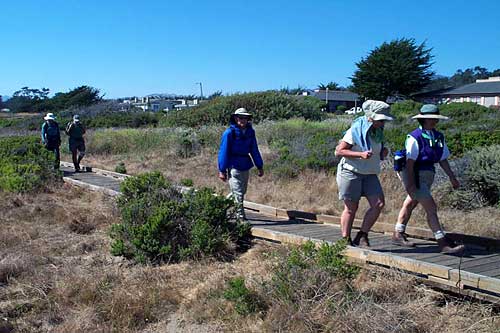
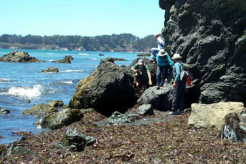
Left: Boardwalk along Moonstone Drive in Cambria. Right: Rock hopping on the beach near Cambria.