
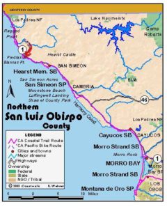
Usage Notes

Legend: For details on the icons and trail colors, please click the legend icon on the map above.

Layers: Other layers are available. See the California Coastal Commission and Coastal Conservancy Completed Sections layer for the official completed trail segments. (About progress on the trail completion project.)
San Luis Obispo Section 2
Piedras Blancas to Adobe Creek
The turnout south of Arroyo del Corral offers the first access to the blufftops not signed no trespassing since north of the motel. Surfers and fishermen regularly park here and climb over the fence to reach the shore. The bluffs here are part of the vast 77,000-acre Hearst Ranch, while the bluffs west of Highway 1 a bit south are held by the U.S. Government, managed jointly by the Coast Guard and the Fish and Wildlife Service. At press time, the Hearst Corporation generally allows access at the turnout by granting a "revocable right to pass" there. Please stay on established paths and respect the private property by observing the following: no camping, no dogs, no fires or smoking. It's important that you stay off the beaches along this section whenever elephant seals are on them, generally October through April but possible year round. Never approach closer than 50 feet to an elephant seal. Not only are the huge awkward mammals dangerous and territorial, intrusions may disrupt their breeding and child-rearing.
The explorer Juan Cabrillo named the Piedras Blancas (white rocks) on his 1542 voyage up the California coast upon seeing their guano-coated surfaces. The Salinan tribe then had winter/spring camps in this area so they could harvest the abundant fish and shellfish. In summer and autumn they would move their camps inland to gather berries, seeds and acorns. Even after the Salinans moved north to the San Antonio Mission, they regularly sent runners 30 miles to the coast to collect seafood and bring it back. In 1864 a lookout was built at Point Piedras Blancas to alert whalers at nearby San Simeon when their potential prey was approaching. In 1874 the lighthouse was built on the same spot. The top of the light station looks incomplete because its Fresnel lens and iron lantern house were removed in 1949 and replaced with an automated beacon. There is no public access to the lighthouse or coast guard reservation, but the Coastal Trail follows a gentle route along its eastern boundary.
From the north end of the turnout, carefully climb over the barbed wire fence at the wooden crossbar and walk west to the bluff's edge. Turn left and follow the iceplant covered bluff edge south. Beyond ⅛ mile the bluff is only a narrow strip west of the highway. At ¼ mile, pass a second turnout offering an alternate access and continue down coast, passing a side trail in 200 feet that drops to a pocket beach on your right.
Before ⅜ mile you want to veer right, crossing the top of a small gully a to head southwest to return to the bluff edge. Follow it out to a small point, then head south around a covelet to cross the neck of another point. Regaining the bluff edge at ½ mile, follow it southeast toward a black water tank at ⅝ mile. You'll pass spur trails down to the beach which you can follow in summer. Stay off the if beach, however, if elephant seals are there.
The bluff edge track passes a fenced pump house beyond the water tank, then crosses a small gully. Contour south through the dunes, passing the end of the beach at ⅞ mile. Continue across the iceplant -covered blufftop on a path heading toward the sphinx-like offshore rock. Follow the path as it ascends a shallow swale until the track swings left beyond one mile. Contour south from there toward the cluster of lighthouse buildings. There's no real path here-just walk over the iceplant.
Beyond 1⅛ miles you reach a small hill above the coast guard reservation fence, now occupied by a U.S. Fish and Wildlife Service group studying marine mammals. Point Buchon, backed by the San Luis Range, comes into view far to the south-southeast. Head for it, staying left of the fence but right of the vegetated sand hills. Cross the lighthouse access road at 1¼ miles and continue along the fence, descending. As you reach the bluff's edge south of Point Piedras Blancas, a small cove behind the fence on your right generally has the first significant herd of elephant seals in season. Turn left and follow the bluff edge northeast.
At 1⅜ miles you overlook one of the elephant seals' favorite beaches where the seals may be seen year round. Continue northeast along the bluff, then contour east through dunes above the beach. Where you must cross a sand gully around 1½ miles, make sure you do so well above all the seals, then follow the sandy bluff southeast above the beach.
You need to head inland around 1 9/16 miles to avoid a cove of the beach. By 1¾ miles you can follow the dunes southeast, generally contouring to the end of the beach at 1⅞ miles. Contour around sandy point, then follow the sandy bluff edge east above a rocky tidal zone. Soon Hearst Castle appears on a hilltop ahead. By 2 miles you follow the bluff edge above another beach favored by elephant seals as a haul out. Dip through small gullies to approach the highway. At 2⅛ miles you pass just south of a highway sign reading "VISTA POINT ½ MILE." You need to parallel the highway briefly to continue down coast. Stay near it to around 2¼ miles. Where you pass the last gully on your right, veer right to parallel above the beach. A series of small grassy points here provide great seal viewing in season.
After you cross a gully, the path left of some high dunes provides the best route. Cross a creek at 2⅜ miles, then head southwest to return to coastal and lighthouse vistas. You quickly meet a hard packed path. Turn left and follow it through more dunes, then contouring along the bluff's edge. After crossing an arroyo around 2½ miles, you reach a fork in the path. Though the high route on the left is about 200 feet shorter, the right fork follows the bluff above the rocky shoreline. Both paths soon approach a vista point parking lot.
Climb over the metal gate to reach the lot at 2⅞ miles, then cross the lot on its ocean side. Beyond the lot, follow the bluff edge path to the next vista point at 3⅛ miles, walk that lot to its end, then continue along the bluff edge. In elephant seal season, a barricade at 3⅜ miles forces you to either turn back or hop the fence on your left. The CCT hops the fence and continues along the road shoulder in seal season, while from May through September if seals are absent, you can continue along the narrow bluff edge west of the highway above another elephant seal beach.
From 4⅛ to 4¼ miles, the only route follows the highway shoulder. Then the CCT leaves the road to pass through another vista point lot. Continue along the bluff edge, passing two promontories at 4½ and 4¾ miles. The easy bluff edge walking continues to a gulch around 5⅛ miles. After scrambling through that eroded zone, contour along the narrow bluff edge between the ocean and the highway.
At 5½ miles you reach a prominent point where the blufftop on the ocean side of the highway ends, giving way to a rocky tidal zone, then sandy beach. At a low tide you can pick your way along the tidal zone, but otherwise you need to turn inland to the highway, turn right and walk the shoulder briefly across Adobe Creek. You quickly reach a wide turnout at 5⅝ miles, the start of San Luis Obispo Section 3.
ALTERNATE ROUTE: Stay on highway shoulder.
SUGGESTED ROUND TRIPS & LOOPS: The headlands around Point Piedras Blancas offer excellent easy hiking whether you start from the north or from the vista point at Milepost 62.7. You can walk the bluff edge, then loop back across the headlands nearer the road, although in winter and spring you'll want to avoid the marshy areas south of the lighthouse road.
Distance: 5⅝ miles (9.1 kilometers).
Open to: Hikers. Bicyclists on road portion.
Surface: Trail, beach, highway shoulder.
Access point: North of Point Piedras Blancas.
How to get there: On west side of Highway at Milepost 64.7, 13 miles north of Cambria, park in the small turnout with room for three or four cars.
Other access: Three vista points west of the highway south of Point Piedras Blancas.
Difficulty: Easy
Elevation gain/loss: 5⅝ miles (9.1 kilometers).
Cautions: Stay off beaches when elephant seals are on them, usually October through April, sometimes year round. Never get closer than 50 feet to an elephant seal.
Further information: None.
Facilities: Cafe, small store and gas station beside motel .5 mile north of access point.
Campgrounds: San Simeon State Park on Section 4 has 202 sites, the 132 sites in the San Simeon Creek unit with access to hot showers.
Lodging: Piedras Blancas Motel just north has reasonable rates. Other lodgings are south in San Simeon and Cambria. Morro Bay Home Hostel, (805)772-9005, is in Morro Bay 30 miles south.


Interested in contributing to this project?
Register to add new photos and information, update existing results and share your trip reports.