
Usage Notes

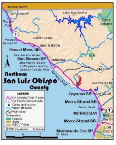
Legend: For details on the icons and trail colors, please click the legend icon on the map above.

Layers: Other layers are available. See the California Coastal Commission and Coastal Conservancy Completed Sections layer for the official completed trail segments. (About progress on the trail completion project.)
San Luis Obispo Section 3
Adobe Creek to Pico Avenue Access, San Simeon Acres
The vast 77,000-acre Hearst Ranch occupies almost all the coastal land and adjacent marine terrace here. While the Hearsts have owned the ranch since the 1860s, locals and travelers, mostly surfers, divers and fisherpeople, have found and used paths to the tideline at several spots, mostly along creeks and arroyos. We ask that you stay off the bulk of the Hearst Ranch, but we believe that the coastal access paths that have been used by avid coast lovers over the past 130 years provide reasonable access to the shoreline in an area where access is extremely limited. At press time, the Hearst Corporation allows this access by granting a "revocable right to pass" at those locations. Please stay on the established paths and respect the private property by observing the following: no camping, no fires or smoking, keep dogs leashed.
Most of this section follows a scenic and diverse shoreline, passing through cypress and pine forest planted by the Hearsts on San Simeon Point to round the gracefully curving shore at sheltered San Simeon Bay. After passing the historic village of San Simeon and W. R. Hearst State Beach, where you leave the trees, you can walk beach or blufftop for another mile before the CCT is forced to follow the highway shoulder to section's end.
From the turnout just east of unmarked Adobe Creek, climb over the green gate and follow the trail south to the tideline. Turn left and follow the tideline east-southeast along a broad beach. You can see Hearst Castle atop the hill northeast and the high hulk above Point Buchon far down the coast. Cross the mouth of Arroyo Laguna/Oak Knoll Creek at ¼ mile, where a windswept lagoon lies on a your left and tidal rocks stand offshore. Local beachcombers have built whimsical driftwood shelters beside this lagoon and at the next arroyo.
Beyond the lagoon, continue along the tideline of a narrowing beach with the eroded dun-colored face of twenty-foot-tall bluffs rising on your left. Pass more tidal rocks around ⅜ mile and continue down the beach past the mouth of a small arroyo. By ⅝ mile two peaks rise above the bluff, followed by that incongruous "castle." Continue past the mouth of a larger arroyo and some vegetated dunes. By ¾ mile, as the dunes give way to bluffs with faces of folded rock, CCT leaves the beach to head east-southeast on a track between the dunes and the vegetated bluffs to their right. The beach-leaving point is also marked by near white rocks embedded in the bluff face.
Just 50 feet from the beach, look for a trail on your right heading south along the bluff's edge. Follow it to dip through a small gully and join another trail from the beach. Continue through ice plant on improved tread. By one mile the ice plant mostly gives way to low grasses as the path continues along the bluff edge overlooking a rocky tidal zone. Don't worry if the path is indistinct-there's always a way through.
Pass an unnamed point around 1⅛ miles and contour above a dark sand pocket beach. The only spurs down to the beach are at its midpoint and near its south end. By 1¼ miles you overlook a sparkling cove where sea otters often play and seals haul out on offshore rocks. Approach the end of the cove's beach around 1½ miles where a rough spur descends to it. Several windows punctuate the rocks below, and the cove's rocky shore sweeps south to San Simeon Point. Soon your blufftop trail leads into a stand of cypress and forks. Bear right to follow the trail on a promenade between two parallel rows of cypress trees. Where the path forks again at 1⅝ miles, go straight along the sheltered track. Soon a spur on the right leads back to the nearby coast.
Continue along the cypress promenade, passing another spur to the coast at 1¾ miles. Just beyond that, the track forks again. CCT goes left this time, contouring southeast through a shady grove to meet a broad path at 1⅞ miles. Turn right and head south, then southeast with the surf crashing on your right.
By 2⅛ miles your trail veers left to head east, then northeast to a T junction. Though you can barely see the ocean for the trees, you've reached San Simeon Point. Take some time to turn right on the spur that explores the amazingly convoluted shore of the nearby point before following the bluff edge track as it swings north to San Simeon village.
CCT goes left at the T junction, heading northwest, then north through forest. Soon Hearst Castle reappears on the hilltop ahead, then the azure waters of San Simeon Bay appear on the right with old San Simeon village beyond. Contour past pines and eucalyptus, enjoying filtered coastal vistas. You may need to climb over some fallen pines around 2⅜ miles. When your path returns to the bluff edge around 2½ miles, follow it north. Soon a barbed-wire fence is on your right. Follow it 150 feet, then duck through a break in the fence (or carefully climb over it) and continue along the bluff edge path.
By 2¾ miles you want to veer right and descend a broad track to the sandy beach, then walk the beach east. After passing a small lagoon at the mouth of Arroyo del Puerto before 3 miles, you can turn left and parallel the creek for 400 feet and duck through a gap in the chain-link fence to explore sleepy San Simeon village and the historic Sebastian Store. CCT continues east along the beach, passIng through W.R. Hearst State Beach, which has picnic tables, water and restrooms.
Pass beneath the pier at 3 miles and continue along the narrowing beach. A stairway on the left 300 feet beyond the pier offers a second escape from the tideline. CCT continues east on the beach, although a narrow point beyond 3⅛ miles is impassable at high tide, requiring a detour to the blufftop via the stairway. Otherwise follow the beach east across Broken Bridge Creek beyond 3¼ miles. Leave the beach at 3⅜ miles and walk the blufftop east to 4 miles and the next arroyo, where you must head up to the highway.
CCT follows the highway shoulder toward Cambria, contouring across a low marine terrace. Cross Little Pico Creek at 4⅝ miles, dip nearly to sea level around 5⅜ miles, then climb slightly to cross the bridge over Pico Creek at 6¼ miles and enter the tourist town of San Simeon Acres. Immediately turn right on Pico Avenue and walk to its end at 6⅜ miles, start of the next CCT section.
ALTERNATE ROUTE: The only other choice would be to stay on the highway.
SUGGESTED ROUND TRIPS & LOOPS: Hike the 2⅛ miles to San Simeon Point and return the way you came more or less, 4¼ miles round trip. You can also walk out to the point from San Simeon village, only 1¾ miles round trip.
Distance: 6⅜ miles (10.3 kilometers).
Open to: Hikers. Dogs OK on leash. Bicyclists on road portion.
Surface: Beach, trail, highway shoulder.
Access point: Adobe Creek.
How to get there: Park in the wide turnout with the green gate on the ocean side of Highway at Milepost 60.0, 1.8 miles north of northernmost of two San Simeon Village turnoffs.
Other access: W.R. Hearst State Beach, anywhere along the highway between the two San Simeons, San Simeon village and San Simeon Acres.
Difficulty: Easy
Elevation gain/loss: 230 feet+/250 feet-. Beach/trail portion: 140 feet+/180 feet-.
Cautions: Please respect the Hearst Ranch property-no fires, firearms, camping or smoking, and stay on established paths.
Further information: W.R. Hearst State Beach (805)927-2020.
Facilities: None except at W.R. Hearst State Beach: picnic tables, water, restrooms.
Campgrounds: San Simeon State Park on next section has 202 sites, but only the 132 sites in the San Simeon Creek unit have access to hot showers.
Lodging: San Simeon Acres at section's end and Cambria 4 miles south have many choices. Morro Bay Home Hostel (805)772-9005 is in the town of Morro Bay 25 miles south.

Interested in contributing to this project?
Register to add new photos and information, update existing results and share your trip reports.