
Usage Notes

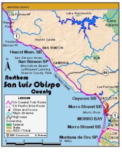
Legend: For details on the icons and trail colors, please click the legend icon on the map above.

Layers: Other layers are available. See the California Coastal Commission and Coastal Conservancy Completed Sections layer for the official completed trail segments. (About progress on the trail completion project.)
San Luis Obispo Section 4
Pico Avenue Access, San Simeon Acres, to Cambria
The land still owned by the Hearst Corporation along the San Luis Obispo County coast finally comes to an end at San Simeon Creek, less than two miles from the north end of this section. Finally public access to the shoreline here becomes clear and specific, unlike the obscure and revocable access ways north along the coast. The number of shoreline visitors rises exponentially, especially around the Pico Avenue access and from San Simeon Creek south to Cambria. Two other significant boundaries occur along this section. The ancestral lands of the Salinan people reach their southern limit near present-day Cambria. Today's California Sea Otter Game Refuge sprawls south along the coast for 100 miles from the mouth of the Carmel River to the mouth of Santa Rosa Creek, which you pass on this section just north of Shamel County Park.
The original Hearst Ranch was much larger than today's 77,000 acres. George Hearst's original 250,000-acre ranch included three vast Spanish ranchos on the northern San Luis Obispo coast--San Simeon, Piedra Blanca, and Santa Rosa and once included 50 miles of coastline from southern Big Sur to Cambria, as well as today's Fort Hunter-Liggett, by itself a vast expanse of wild lands. George Hearst began buying the lands after the 1863-64 drought killed many of the original land grant holders' livestock, leaving the Spaniards deeply in debt. San Simeon had a whaling station when Hearst took over in 1865. He built warehouses, a pier and store on San Simeon Bay, adding to his mining fortune by exporting local products. The illiterate George Hearst brought his family to San Simeon to camp up on Camp Hill, creating a lasting impression with his only offspring, William Randolph Hearst. Only after the younger Hearst inherited the family fortune upon his mother's passing in 1919 did he retain architect Julia Morgan to design what today is known as Hearst Castle. Construction continued for more than 30 years, with Hearst using the San Simeon pier to import art treasures and fully grown trees from around the world to decorate his immense play house, visited by numerous international celebrities.
From the end of Pico Avenue, descend the stairway to a cobblestone beach. Turn left and walk the tideline south, crossing a sandstone shelf around ⅛ mile.
(You can also walk the beach about ⅛ mile northwest to a point.) Beyond the shelf, continue along the beach below motel row, passing the mouth of the Arroyo del Padre Juan where another access path follows the north bank. Walk a sandy beach there, then sand alternates with cobbles and uneven rocks.
Pass the last condominium on the bluff at ⅜ mile and continue down the beach to a rocky point at ½ mile. It takes a tide of +4.0 feet or less to walk the beach around the point. Otherwise you can climb to a path along the bluff's edge. Turn around to admire the sweeping view up the coast to nearby San Simeon Point with Ragged Point beyond.
Beyond the point you walk a beach of rougher terrain than the last one, with another mix of sandstone shelves, cobbles and pockets of sand. Follow it past another small point, coming to the mouth of a small arroyo at ¾ mile. When you round the next point in 250 feet, you'll need a lower tide to walk the beach beyond. If you can't proceed along the tideline, it's easier to climb to the blufftop alternate path before you round the point. Continue along beach or blufftop, rounding another small point at ⅞ mile.
Beyond one mile you pass rocks standing both offshore and near the bluff edge. The bluff path is easiest here as many rocks make the tideline rough going. After another point around 1¼ miles, you must return to the beach before coming to the wooden fence of a private residence. The beach is passable at all but the highest tides of +5.0 feet or more. It's easier to return to the tideline well before you reach the fence, where steep rough descent requires caution.
Continue along the beach. Around 1⅝ miles 30-foot-tall Pico Rock stands offshore and 40-foot tan cliffs rise on your left. Reach state park property beyond 1¾ miles, although it's not marked on the beach. The bluff veers inland to the nearby highway. By 1⅞ miles, the north end of the highway bridge over San Simeon Creek lies due east of the tideline. A short walk east under the bridge would lead to the San Simeon Creek Campground of San Simeon State Park in ⅛ mile, but you'd want to stay on the north side of the lagoon.
CCT continues south along the sandy tideline, passing the seasonal outlet of San Simeon Creek, a small point around 2⅛ miles, then along sandstone bluffs that rise 40 feet on your left. Round a point at 2⅜ miles where a cluster of rocks rise offshore. Continue down the beach to 2⅝ miles where, just before another point, you want to ascend steps to the blufftop. Follow the blufftop path briefly to Moonstone Beach Vista Point at the north end of Moonstone Beach Drive.
Walk south past the parking lot to pick up the blufftop path and follow it down the coast. After a broad point at 2⅞ miles, the path veers east briefly, rounds a cove and passes another point at 3¼ miles. Contour along the blufftop to Leffingwell Landing and another parking lot at 3¾ miles. Just north of it, picnic tables in a sheltered cypress grove offer a nice spot for a break.
Continue along the blufftop path, watching the rocky tidal area below for sea otters which favor this spot. By 4 miles the path descends from the low blufftop to the parking lot for Santa Rosa Creek Access. Descend to the beach and walk the tideline south, crossing the seasonally flowing mouth of Santa Rosa Creek west of its broad, crescent-shaped lagoon. When you pass the south end of the lagoon at 4¼ miles, the CCT turns east to leave the beach and follow a path along the northern edge of Shamel County Park. While the beach extends about ⅛ mile south, it has no exit at its south end.
Around 4⅜ miles the park path comes to a parking lot at a bend on Windsor Blvd. To detour into the pleasant town of Cambria, head east on Windsor Blvd., cross Highway 1 in ¼ mile, then walk Main Street into town. For the CCT, turn right and walk the sidewalk of Windsor Blvd. through a residential neighborhood to road and section's end at 5⅛ miles. The East-West Ranch access path that traverses the bluffs ahead is described in Section 5.
ALTERNATE ROUTE: At low tide you can walk Moonstone Beach from the vista point south. Of course you could walk the highway shoulder if you're in a hurry.
SUGGESTED ROUND TRIPS & LOOPS: You can choose any one of several spots to start pleasant beach walks along this section of the CCT: Pico Avenue, Arroyo del Puerto, San Simeon Creek, Santa Rosa Creek or Shamel County Park. Another choice is to walk the blufftop path between Moonstone Vista Point and Santa Rosa Creek Access.
Distance: 5⅛ miles (8.2 kilometers).
Open to: Hikers, dogs. Bicyclists on road portion.
Surface: Beach, trail, sidewalk.
Access point: Pico Avenue Access.
How to get there: Turn west off Highway at north end of San Simeon Acres (motel row) 4 miles north of Cambria at Milepost 54.75 onto Pico Avenue, go straight .1 mile to end of street and park.
Other access: Directly south of the Cavalier Inn in San Simeon Acres a public path leads along the north bank of Arroyo del Padre Juan. Also at west end of San Simeon Creek Campground at San Simeon State Park, San Simeon Creek Access south of creek, Moonstone Beach Vista Point, Leffingwell Landing, Santa Rosa Creek Access, Shamel County Park.
Difficulty: Easy
Elevation gain/loss: 130 feet+/90 feet-.
Cautions: Watch for rogue waves and rising tides along the beach.
Further information: San Simeon State Park (805)927-2035, San Simeon Chamber of Commerce (805)927-3500.
Facilities: None at access point. San Simeon State Park has a phone near the entrance kiosk and restrooms and water in the picnic area south of San Simeon Creek. Leffingwell Landing and Shamel County Park have restrooms, water and picnic tables.
Campgrounds: San Simeon State Park has 202 sites, but only the 132 sites in the San Simeon Creek unit have access to hot showers.
Lodging: San Simeon Acres has several choices of motels, while Cambria has a more diverse mix of lodging. Moro Bay Home Hostel (805)772-9005 is in Morro Bay 22 miles south.
Points of Interest

In the News

Interested in contributing to this project?
Register to add new photos and information, update existing results and share your trip reports.