

August 13: San Luis Obispo County Villa Creek to Morro Bay. 13.0 miles Our camp this morning was quite damp. The thick night fog had deposited moisture on every surface: our tents, equipment, the park tables. Breakfast was a stand up affair.
After driving back to Villa Creek, we made our way to the beach via a rope-defined path through a back dune and sand area utilized by our friends the Snowy Plover for their nesting sites. We then joined up with Mary Bettencourt of the Cayucos Land Conservancy. The lands from Highway One to the ocean between Villa Creek and Cayucos have been preserved for everyones enjoyment. The Trust for Public Land, with help from the Packard Foundation, helped in this effort. The end result is that California State Parks owns the land in fee, and the Cayucos Land Conservancy owns a conservation easement over the same land. That partnership will determine the final disposition of this excellent piece of coastal bluff.
At several instances as we walked along, we were at the line between fog and sun. The result was walking along with rainbows for companions. Along the way were Native American grinding holes in the rock outcrops along the bluffs edge. Our walk was along what I would describe as a perfect California Coastal Trail. Situated along the bluff top, it is a modest dirt path. It does not affront the landscape yet it provides a simple and straightforward means of enjoying the coast. To enlarge it would be to diminish it.
We then entered Cayucos and met by chance Art and Thelma Cary, local residents who became Coastwalk- and coastal-trail-backers from our meeting. Art offered coffee for all, and a goodly number of us took him at his word. Thanks to the Carys for helping the CTE 03.
Past the wharf of Cayucos, we were back on the broad sand beach. For the first two miles or so, the bluff was devoted solely to houses, the bluff-sea foot was armored with sea walls, some with oversize American flags painted upon them. Along the way, we came upon an extended family happily digging a pit in which to have a clam bake, with clams, crab, lobster to be steamed over a bed of seaweed on hot rocks. Never mind that they had chosen a spot close enough to the water so that as they dug sea water percolated up from the bottom of the hole, creating a sort of a self extinguishing fire pit. It seemed only that their joy for each other was all that really mattered.
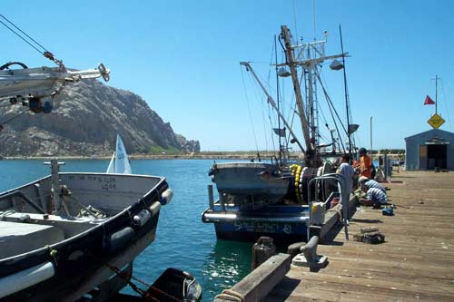
After our lunch break, the fog finally lifted, revealing Morro Rock to the south, about three miles away. We easily walked that section on hard sand. As we walked along, we scattered long-billed curlew, godwits and the ever-present seagulls. We ended our day’s work at the office of the Morro Bay Harbor Master.
We returned by Melmobile to Morro Strand State Park and our camp. Before me, as I sat in my beach chair awaiting the arrival of our dinner, was my entire day’s work. Far to the north was the point of land at Villa Creek. Cayucos also could be seen in that direction. To the south lay Morro Rock and the three stacks of the Duke Energy power plant at Morro Bay. Offshore pelicans dived and seals jumped for me. Anchovies between them were less thrilled with the situation. Far to the northwest, whales, probably blues, spouted at the horizon line. Farther away to the south stood Montana de Oro, which was far, far away when we first saw it from the Sur region; now it is only a day or two away. Before me, people are enjoying the beach, and shorebirds are making their living from it. (Jon Breyfogle; photos by Linda Hanes.)
Left: Indian mortars. Right: Pier at Morrow Bay.
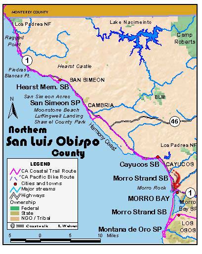
For trail section - San Luis Obispo Section 4, San Luis Obispo Section 5, San Luis Obispo Section 6