

August 14, San Luis Obispo County Morro Bay to Montaña de Oro. 7.0 miles
Montaña de Oro to Foothill Rd. 10.8 miles
Yes, that’s right. Two hikes.
The day started at 8 am when our mystery day leader appeared at the Morro Bay Harbormaster’s Office. We soon were ferried in two of the Harbor Patrol boats to the south side of the entrance to Morro Bay. The boats were nudged up onto the sand and we hopped out to begin our walk.
The first 5 or so miles were on the firm sand of the spit that runs from the entrance to the harbor to the bluffs at Montaña de Oro. As it had in some of the northern counties, dense fog at times enveloped the walkers. By careful spacing you could completely separate from all the others and walk in your own gray shrouded cocoon. As we walked, we would often see deer and smaller mammal tracks leading from the dunes of the back beach down to the waters edge.
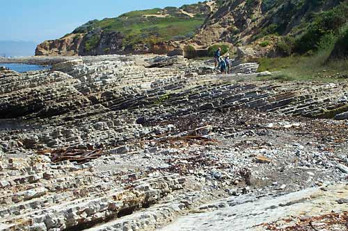
The bluffs of Montaña de Oro began rising, and the beach sand was soon replaced with striated rock; layer upon layer tilted up, so first it appeared we were walking down stairs and then switching, so we were going up. Unable to pursue our way south at the shore, we took a steep sand trail up to the bluff above. I assume that because these trails are used by horses, they have been worn as deep notches in the ground. Because of this, we were able to see the immense root systems of the bush lupines at the sides of the path – the lupines in their search for water and minerals have created an excellent sand-bluff erosion-prevention system.
Once at the bluff top, we headed the mile or so to our campsite for the night. Only foot traffic was moving then. The roadway was shut down in both directions, so an automobile commercial could be made. The things we do for the corporate world.
PG & E denied the Expedition access to the large piece of land they own surrounding the Diablo Canyon Nuclear Reactor. In 1996, the Whole hikers could walk this property with the exception of a 5-mile stretch of road walking. No such deal this time around, so a large and beautiful section of our coast is denied us. Some of us decided that in order to keep the integrity of our hike intact, we needed to walk around this restriction. Straight down the coast, it’s 10 miles or so from Montana de Oro to Avila. Going around, it’s 20.
So, 20 miles of road walking lay before us. Our scheduled hike over by noon, seven of us – Ginny, J, Diana, Linda, Steve, Mike and I – took of for an afternoon’s ramble that ended up being 10.8 miles. This was all road walking on Oso Valley Rd. and not especially pleasant, but the jaunt had some positive aspects. Along the way we met up and were filmed and interviewed by Joe Olvera of KSBY channel 6 of San Louis Obispo. We were able to point out why it was that a group of coastal hikers were heading inland. The road was not without its nice aspects; once out of built up areas, we could look at the extensive agricultural lands on either side. A scary aspect of this region was also evident sirens on poles dotted the landscape to warn of a nuclear accident. When they say that safe nuclear power is promoted, they dont mention this warning system.
We had no set destination for this walk. We were just trying to get miles in, miles we would not have to walk the next day. By prearrangement, the Melmobile appeared sharply at 5:30, and we were whisked off to our dinner prepared by the Baywood “Navy”. Motto: “we don’t sail in water deeper than we can stand in. Another motto is “you can never have too many boats.” One of the members (who are all admirals if they want to be) rescues pelicans and other small boats. They sail when the tide is high in the back bay. (Jon Breyfogle; photos by Linda Hanes)
Left: Ferry across Morro Bay to the spit. Right: Montaña de Oro State Park.