
Usage Notes

Legend: For details on the icons and trail colors, please click the legend icon on the map above.

Layers: Other layers are available. See the California Coastal Commission and Coastal Conservancy Completed Sections layer for the official completed trail segments. (About progress on the trail completion project.)
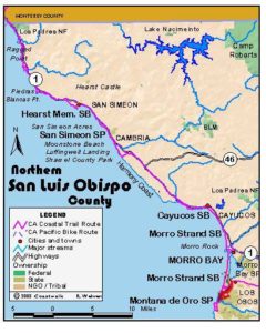
San Luis Obispo Section 7
Cayucos Pier to Morro Rock to Harbor Street, Morro Bay
This section consists of one of the longest beach walks to this point in Volume Two, followed by a short walk through the harbor district of the town of Morro Bay. While most of the walking lies within sight of houses and commercial districts, the towns of Cayucos and Morro Bay are small with steep and mostly undeveloped coastal hills towering directly behind them, giving the walk a more natural feel.
The hike described here ends on the shore of Morro Bay. To continue south on the CCT from there, you'll want to hire a boat to take you out to the sand spit on the bay's west shore, where SLO Section 8 begins. This is the first boat shuttle in Volume Two, in fact the first since Bolinas Lagoon north of San Francisco. At press time there were no companies offering boats for hire at Morro Bay. We recommend you call the Harbor Office, (805)772-6254, and ask if they can refer you to an individual or company with boats for hire, or ask around on the docks along the Embarcadero.
From the foot of Cayucos Drive, walk down to the tideline beside the Cayucos Pier, turn left and walk the tideline of the sandy beach south, passing numerous small offshore rocks. Pass the mouth of Little Cayucos Creek by ⅛ mile. Continue past the first of many public stairways between the beach and the streets of Cayucos. Beyond this stairway from First Street, you soon leave Cayucos State Beach for Cayucos City Beach. Soon the bluffs, lined with houses, rise forty feet on your left. Cross a seasonal creek around ⅜ mile, then round a small point. Continue down the beach, which narrows at the south end of town. While it may be impassable at high tide, you can detour up one of the stairways, walk along Pacific Avenue, then return to the beach by the stairway at 24th Street. Pass 24-foot-tall Whale Rock by 1⅛ miles, the largest of the small rocks offshore. You promptly enter Morro Strand State Beach. Soon the beach becomes broad again. Walk the broad strand down the coast, passing a lagoon on your left a at the mouth of the seasonal creek that descends from Whale Rock Reservoir. The beach narrows again by 1⅝ miles, with the Highway 1 freeway not far inland, l then houses lining the top of the beach.
Cross the mouth of Willow Creek beyond 1⅞ miles. Continue along the sandy tideline, leaving the north unit of Morro Strand State Beach at 2½ miles. Ironically CCT also leaves the residential neighborhood, following a broad beach with the freeway 400 feet inland. As you continue south, the mountains dip to reveal the deep canyon of Toro Creek, which you cross at 3⅛ miles. Around 3⅜ miles, walk the tideline at its nearest point to Freeway l. Then the beach angles away from the road, running out to point lined with low offshore rocks. a Enter the south unit of Morro Strand State Beach beyond 3⅝ miles. Continue along the tideline past the state park campground at the top of the beach to 4¼ miles. Cross the mouth of Alva Paul Creek at the south end of the campground, then continue along the beach, passing the Cloisters area of the state beach around 4½ miles.
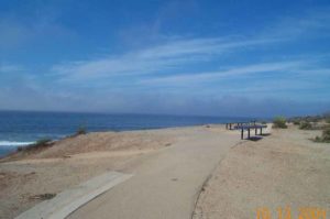
Walk the tideline of the state beach south toward impressive Morro Rock. The beach turns very broad with sand dunes rising above its upper end and the north end of the city of Morro Bay farther east. Leave Morro Strand State Beach for Morro Rock City Beach at 5⅜ miles, with the Atascadero Road access on the east boundary. Continue along the tideline toward towering Morro Rock, passing a private campground east of the broad beach.
After you cross the mouth of Morro Creek at 5⅝ miles, the PG&E power plant towers on your left and 578-foot Morro Rock towers on your right. Continue along the tideline until you almost reach the base of Morro Rock at 6⅛ miles. Leave the tideline and walk the almost level sand spit south to meet Coleman Drive along its south shore before 6¼ miles. From here you might want to make a side trip southwest to the ocean side of Morro Rock, about ¾ mile round trip. Otherwise turn left and walk the shoulder of Coleman Drive east. Around 6⅜ miles, Coleman Park on your left offers picnic tables, restrooms and a playground, a nice spot for a break. Continue east along the waterfront street, which soon becomes Embarcadero and turns southeast. Follow Embarcadero to the foot of Harbor Street at 7⅛ miles. Turn right and walk to the harbor office. That is where this section ends and the next one begins.
ALTERNATE ROUTE: At high tide, you may need to exit the beach at the south end of Cayucos, climb one of the beach access stairways to Pacific Avenue and follow it south to the stairway at 24th Street, where you can return to the beach.
SUGGESTED ROUND TRIPS & LOOPS: Explore the tideline and beach around the base of Morro Rock. Walk the beach north or south from Morro Strand Campground or south from Cayucos Pier and return the way you came.
Distance: 7⅛ miles (1 1.4 kilometers).
Open to: Hikers. Bicyclists on road portion.
Surface: Beach, city streets.
Access point: Pier, Cayucos State Beach.
How to get there: Exit Highway 1 at Cayucos onto Cayucos Drive and drive south to its end near the pier.
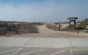
Other access: Nine public beach stairways between First Street and 22nd Street, 24th Street, north end of Studio Drive, north of Juanita Avenue, stairways at ends of Coronado, Mayer, Mannix and Cody avenues, through campground at west end of Yerba Buena Drive, Orcas Street, Hatteras Street, Easter Street, Beachcomber Drive, Atascadero Road, Coleman Drive (Morro Rock) and Embarcadero.
Difficulty: Easy
Elevation gain/loss: Negligible.
Cautions: A few points along the beach will be impassable at high tide, although you can usually find a nearby detour.
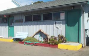
Further information: Cayucos State Beach (805)549-3312, Moro Strand State Beach (805)772-7434, Moro Bay Harbor Office (805)772-6254.
Facilities: Cayucos Pier has restrooms, picnic area, water and phones at adjacent Veteran's building. Restrooms, picnic tables and water at end of 24th Street. Coleman City Park has restrooms, picnic tables.
Campgrounds: Morro Bay has two private and two state park campgrounds.
Lodging: Many choices in Cayucos and Morro Bay. Morro Bay Home Hostel (805)772-9005 is nearby. Hostel Obispo (805)544-4678 is 14 miles east in San Luis Obispo.
Points of Interest

In the News
Interested in contributing to this project?
Register to add new photos and information, update existing results and share your trip reports.