
Usage Notes

Legend: For details on the icons and trail colors, please click the legend icon on the map above.

Layers: Other layers are available. See the California Coastal Commission and Coastal Conservancy Completed Sections layer for the official completed trail segments. (About progress on the trail completion project.)
San Luis Obispo Section 8
Morro Bay to Sand Spit to Montaña de Oro State Park South Boundary
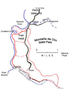
Montana de Oro State Park offers 8400 acres of the wild central California coast at its best. Its seven miles of shoreline range from the low sand spit in the north through extensive vegetated sand dunes around Hazard Canyon west of the park road to spectacular, diverse rock formations along the coast in the center and south of the park. In addition to the Coastal Trail described here, the park has nearly 50 miles of trails that explore canyons, peaks and ridges east of the park road. The park's name, meaning mountain of gold, refers to the abundant blooms of mustard and California poppy found here in spring. The park visitor center occupies an old ranch house perched above Spooners Cove at the campground entrance. The visitor center is open weekends, daily during summer months. While the Chumash people lived in the area for thousands of years, this has always been a rugged and wild stretch of coast. The original Spanish land grant here came to be known as Rancho Canada de los Osos y Pecho y Islay, literally the Valley of Bears, Bravery and Wild Cherry.
Although we describe the Coastal Trail here from the tip of the sand spit west of Morro Bay, you can also drive to the center of this section at the end of Sand Spit Road and follow the CCT either north or south from there.
If you take a boat ride to the sand spit, walk west to the tideline and follow it south. Around ¾ mile you pass the south breakwater protecting the harbor mouth, with views over Morro Bay to the east. Contour down the beach, entering Montaña de Oro State Park at 1¼ miles. CCT continues along the west shore of the sand spit, passing sand dunes of increasing height that hide the bay as you head south.
By 2⅝ miles the dunes to your east reach 90 feet in height as you follow the tideline. If you want another view of Morro Bay, detour east to climb an 80-foot dune. Otherwise follow the west shore south, passing a low gap in the high dunes around 3⅛ miles. The heart of the dunes are protected here in Morro Dunes Natural Preserve.
Pass the south end of Morro Bay to your east around 4¼ miles. Watching on your left you soon might notice a trail that forks left to head southeast into the dunes, the first of many trails in this wonderful state park. That trail connects with a path along the east shore of Shark Inlet at the south end of Morro Bay.
CCT follows the Pacific shore south. Around 4¾ miles it meets the Rim Trail climbing into the high dunes on your left. This is shortest of several choices for the CCT through route, the detour around PG&E's Diablo Canyon Nuclear Power Plant property that requires a 20-mile road walk before returning to the coast. While we highly recommend the hike described in the rest of this section, through-hikers on tight schedules may want to follow the Rim Trail east ¾ mile to Pecho Valley Road, then walk Pecho Valley Road north to Los Osos Valley Road to make the detour.
Otherwise, continue south along the tideline. At 5 miles you pass a broad, distinct side trail that ascends ¼ mile to the parking lot at the end of Sand Spit Road. By 5⅛ miles a soft sandstone layer appears beneath the high dunes on your left. The sandstone layer gets progressively taller as you walk south. Pass a deep gully in the dunes around 5⅜ miles and two smaller gullies before 5⅝ miles, where a rock shelf crosses the beach and extends into the tidal zone. Continue past a trans-Pacific cable landing to approach Hazard Reef. Reach the reef's rocky shore, then pass a high point on the bluff above around 6 miles. The shoreline cuts in to Hazard Creek flowing out of its deep canyon.
Since you can't easily get through to Spooners Cove by walking south along the shore, CCT turns left to follow the trail up the canyon to a junction. The Hazard Reef Trail on the left ascends steeply, then loops back to Sand Spit Road or the CCT road detour. The CCT, however, takes the unmarked right fork, climbing the Hazard Canyon Reef Trail on a boardwalk beside the creek, then steps up to the sandy blufftop where you come to an unmarked junction at 6¼ miles. The trail straight ahead leads ⅛ mile to a parking area on Pecho Valley Road. CCT turns right to ascend the Dune Trail, which is overgrown for the first 200 feet, then continues on better though still narrow tread through chaparral.
After the next junction before 6⅜ miles, where the left fork leads to a parking lot, the Dune Trail contours south through vegetated dunes. Pass under a power line at 6½ miles, then generally contour south along it, the coast obscured by the high dunes on your right. Descend gently at 6¾ miles with the hills of PG&E's property visible ahead.
At 7 miles you reach a trail junction where the road and the Ridge Trail parking area are nearby on the left. The equestrian Dune Trail descends south toward Spooners Cove visible ahead. The CCT turns right on slightly longer and more a scenic route, angling northwest to T junction overlooking dunes along the a shore at 7¼ miles. Turn left and contour along the bluff edge through densely vegetated dunes. Descend south from 7⅜ miles with grand views of Spooners Cove below and prominent Islay Point beyond it. Your path turns east before 7½ miles, contouring toward the park road and passing a prickly pear a cactus, probably planted when this was ranch land.
Reach a junction beneath power lines at 7⅝ miles. Turn right and descend the narrow path toward the cove, soon reaching the paved road. Turn right, follow the road across the bridge over Islay Creek and turn right again to walk south across the Spooners Cove parking lot. Just beyond it at 7¾ miles, you reach the bottom of a stairway. Climb the rough steps beside a stratified rock outcrop to meet the paved road. Turn right and ascend its shoulder south, then southwest to the Bluff Trailhead at 7⅞ miles.
Take the Bluff Trail south to cross a bridge over an arroyo, then west to a junction at 8 miles. Take the right fork and head west out to the tip of Islay Point before 8¼ miles, which offers stratified rocks protruding west into the surf zone and magnificent views of Spooners Cove and the coast north. Head southwest to another facet of the point, then contour south along the bluff above a rugged rocky shore. Around 8⅜ miles a spur on the right descends to Corallina Cove's fine beach. Turn around for a view north to Morro Rock and the coast beyond it.
CCT contours along a broad blufftop track, soon swinging east around a deep canyon. When you see a bridge over the canyon, turn right and cross it, then turn right again on the Bluff Trail to head west back to the shore. By 8½ miles your trail winds south along the bluff's edge, soon coming to a junction where you stay to the right. Follow the Bluff Trail across a gully and wind to meet a spur trail on the right. CCT turns right on the spur, heading to the tip of a point.
By 8¾ miles your trail ends at the main Bluff Trail. Turn right and contour south with grand views of the rugged, convoluted shore. You pass long finger-like points with narrow ocean inlets between them. To the east the steep hills reach nearly to the shore.
By 8⅞ miles you overlook Quarry Cove, coming to a spur on the right that dips to a picnic table above the rocky cove. Follow the Bluff Trail, contouring to a junction beyond 9 miles. The broad track on your left climbs east to the road. Take the broad right fork to continue along the shore. By 9¼ miles you overlook tunnel-riddled Grotto Rock just off a rugged sculpted shore. Contour south across a level marine terrace, passing several spurs on the right that explore higher points, then a spur on the left before 9⅜ miles. From the Bluff Trail/CCT you soon overlook the pristine inaccessible beach at the mouth of Coon Creek. By 9½ miles your trail winds inland briefly, paralleling the ugly chain-link and barbed wire fence marking that PG&E property before coming to a sign, "END OF TRAIL." From here you have a view south to the level marine terrace extending south to nearby Point Buchon and beyond, with a high rounded 1424-loot peak rising on its left that perches on the state park/PG&E boundary.
You must backtrack to the trail at 9⅜ miles and follow it east through chaparral to the paved park road at 10 miles. Across the road there you'll find chemical toilets and picnic tables beside the Coon Creek Trailhead, with the PG&E gate just a few feet down the road.
This is all the rightful CCT route. The ideal, completed CCT would continue south across what's currently PG&E land, but until the utility giant opens that route to the public, you have only two choices:
Return north via the route you came or along the shoulder of Pecho Valley Road.
ALTERNATE ROUTE: While this entire route is highly recommended, through-hikers might choose to skip part of Montaña de Oro, heading east on either the Rim, Sand Spit, Hazard Reef, or Hazard Canyon trails to Pecho Valley Road and walking it north to begin the long road detour described in Section 9.
SUGGESTED ROUND TRIPS & LOOPS: Montaña de Oro State Park offers many great choices for day hikers. Get the park map and consider loops combining the CCT with the Coon Creek and Rattlesnake Flats trails at the south end of the park, the Reservoir Flats, Valencia Peak, Oats Peak and Badger trails near Spooners Cove, or the Bloody Nose and Manzanita trails near Sand Spit Road. These trails only scratch the surface of the many possibilities here.
Distance: 10 miles. 5 miles to Sand Spit Road trail, 6¼ miles to Dune Trail, 7¾ miles to Spooners Cove (16.1, 8, 10.1, 12.5 kilometers).
Open to: Hikers. Equestrians on Dune Trail. Bicyclists on Bluff Trail.
Surface: Beach, trail.
Access point: West end of Harbor Street, Morro Bay. To hike this section without making the boat shuttle across Morro Bay, start your hike from the end of Sand Spit Road.
How to get there: Exit Highway to downtown Morro Bay, take Morro Bay Blvd., which soon splits and becomes one way, putting you on Harbor Street, which you drive to the end.
Other access: Montaña de Oro State Park.
Difficulty: Easy
Elevation gain/loss: 310 feet+/190 feet-. Negligible for first 6 miles.
Cautions: To begin this section from the north, you must hire a boat to cross Morro Bay to the sand spit. Contact the Harbor Office, (805)772-6254, and ask if they can refer you to an individual or company with boats for hire, or ask around on the docks along the Embarcadero. Watch for rogue waves along beach portion. Day hikers can start at Sand Spit Road parking area at Montaña de Oro State Park and walk north to tip of sand spit or south to section's end.
Further information: Montaña de Oro State Park (805)528-0513, Morro Bay State Park (805)772-7434.
Facilities: Restrooms, water and phone at access point. Handicap accessible chemical toilets, picnic area and phone at Sand Spit Road parking area. Picnic area at Spooners Cove, with phone at park headquarters and water at campground nearby.
Campgrounds: Morro Bay has camping with hot showers in two state park campgrounds, Morro Strand State Beach on previous section and Morro Bay State Park about 2 miles south of town, plus two private campgrounds. Montaña de Oro State Park has primitive camping.
Lodging: The town of Morro Bay and vicinity offers many choices. Morro Bay Home Hostel (805)772-9005 is nearby. Hostel Obispo (805)5444678 is 14 miles east in San Luis Obispo.
Points of Interest

In the News

Interested in contributing to this project?
Register to add new photos and information, update existing results and share your trip reports.