
September 15: San Diego County San Clemente State Beach to Las Pulgas Road. 11.7 miles
Steve Kononenko has taken over as hike leader, a position he will hold for the entirety of San Diego County. The weather has been our friend for this entire trip, and this was again true this day. High overcast and cool temperatures made the walking easier than many of us (especially those of us from the north) thought we would be experiencing along the southern coast of the state.
For the first 8 miles or so, we were on the beach, making our way through soft sand or over small cobbles. It was not especially easy walking. Just before we left Orange County and passed around San Mateo Point, we passed below the Western White House. Here, Richard Nixon wrestled with the ignominy of his resignation. The surfers in the water couldn’t care less; their gaze was to the west looking for the next set of big waves.
The next section of beach was under the jurisdiction of Camp Pendleton, and it is used as a private military campground. Coastwalkers in the past have been hassled here regarding access, but we had no problems at all.
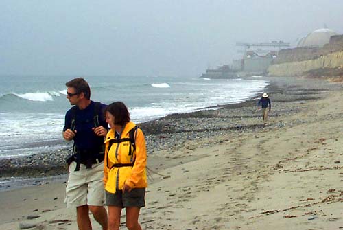
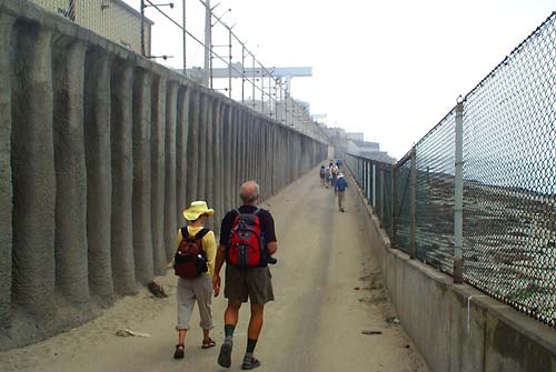
Then came San Onofre. Looming ahead was Con Eds nuclear electric-generation plant, an affront to the coast if there ever was one. Riprap at the waters edge here is topped with an access way, fenced on the ocean side and on the other side with a tall wall topped with another fence. Along the way, canisters designed to reveal the presence of radiation were chained to the fence. At either end of the walkway, armed guards watched the entrances. Here we were, all ten of us, walking within feet of this nuclear plant, yet in San Louis Obispo we were forced to walk more than twenty miles around Diablo Canyon because PG & E refused us access. It seems clear that, having walked by this one, we should have been able to walk by the Diablo Canyon plant. In the name of “safety” or “national security”, we are being denied access to miles of our coast. This condition needs to be changed.
South of the San Onofre nuclear installation, we walked along the beach of San Onofre State Beach, so the bluff tops here were not covered with houses. These bluffs at first had a sandstone base some thirty or forty feet high, topped with another like amount of red brown dirt. This top layer had within it layers of cobbles. As we walked south, the sandstone layer became thinner and thinner, until it was completely gone. The result was that the sandy beach we had been walking was then transformed into a cobblestone one: the cobbles which were formally high up on the bluff face had been pried loose and were now subject to wave erosion.
A mile or so further on at the southerly end of the state beach , we rose up to the bluff top and began a four mile section walking on a paved bike path that in former times was Highway 1. Here it has a sign as it passes under I-5 that warns hikers and bicyclists to be ready to retreat or run if military vehicles pass through. We ended the days exertions at Las Pulgas Road, near one of the main gates into Camp Pendleton, and rode in our van on I-5 through Pendleton, because we were refused permission to walk through the 9 mile stretch. (Jon Breyfogle; photos by Linda Hanes)
Left: Janette and J walk San Onofre Beach, power plant looming in the background. Right: Walkway along side of the power plant allows public passage along the coast.