
Usage Notes

Legend: For details on the icons and trail colors, please click the legend icon on the map above.

Layers: Other layers are available. See the California Coastal Commission and Coastal Conservancy Completed Sections layer for the official completed trail segments. (About progress on the trail completion project.)
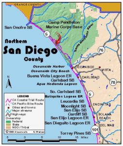
San Diego Section 1
San Clemente State Beach to San Onofre State Beach
One of the best beach walks and some of the least disturbed coastal bluffs left in southern California highlight this first San Diego County section. Only the presence of the San Onofre Nuclear Power Plant perched on the shoreline mars the primitive and picturesque scene. While the section starts at San Clemente State Beach in Orange County, it passes into San Diego County after only 1⅜ miles. Most of the section follows the beaches of San Onofre State a Beach, a lightly developed state park unit where the land is leased from the Marine Corps, operators of the immense and rugged 130,000-acre Camp Pendleton Base surrounding San Onofre. A paved bike path runs the length of the section, starting at Avenida del Presidente in San Clemente, crossing to the west side of the highway at Cristianitos Road, then following Basilone Road and the Bluffs Campground road to section's end, where it continues through Camp Pendleton.
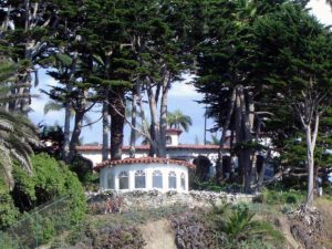
From the San Clemente State Beach day-use parking area, take the wide trail down the bluffs about ⅜ mile to the wild and sloping beach. After passing through a tunnel under the train tracks, continue to the tideline, turn left and walk down the beach. In the distance palm trees on the horizon mark San Mateo Point. You leave state park land by ⅜ mile, but continue walking down the steeply sloping beach below 60-foot bluffs. Before the point around one mile, notice the small white building standing on its own overlooking the ocean above Cotton's Beach, a prime surfing spot. The building was part of Richard Nixon's Western White House and the location of many cigar-smoke-filled meetings with powerful people.
Continue down the beach to round curving and sandy San Mateo Point around 1⅜ miles, crossing the unmarked boundary into San Diego County. Beyond the point the bluffs end and you pass another famous surfing spot, Trestles, named for the railroad bridge crossing San Mateo Creek. When the Marines controlled the area, they toiled constantly to keep surfers from the outstanding break. Now it's a busy public beach and surfers definitely rule, though they must walk a ways to get here. Wetlands lie inland from the creek's mouth.
Continue along the beach around a sandy, unnamed point at 1¾ miles. You soon pass in front of a private camping area and pass below 80-foot bluffs towering over the train tracks, then reach Surfer's or Surf Beach (part of San Onofre State Beach) with parking and chemical toilets all along Basilone Road at the base of the bluffs. You pass a small lagoon above the mouth of San Onofre Creek before 2⅜ miles. Continue along the seaward curving beach. About midway along Surfer's Beach around 3 miles you pass a small monument inscribed "The Point" with a surfboard mounted atop a flagpole.
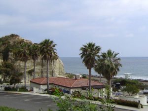
At the end of the beach at 3⅞ miles you reach the imposing structure of the San Onofre Nuclear Power Plant. Pass directly in front of it on a walkway built atop the seawall protecting the plant from the ocean. Past this affront to the senses and to a continuous beach, you return to beach at the base of fantastically eroded sedimentary bluffs with beautiful coastal sage scrub on top and clinging to the cliff. This is one of the best remote beaches in California, a prime example of what southern California looked like before the human tide enveloped much of the land.
Continue down this beach at the base of 60-foot bluffs. The railroad and the San Diego Freeway both run along the marine terrace atop the bluffs and below the towering hills of Camp Pendleton. By 4⅜ miles the San Ono[re Bluffs Campground entrance lies hidden atop the bluff on the old Pacific Coast Highway. As you continue down the beach, the bluffs rise 140 feet in places. Beyond the mouth of a seasonal creek at 5 miles, the first campsites perch atop the bluff.
Continue down the beach passing another creek flowing from a deep canyon at 5¾ miles and plenty more campsites on the bluff. San Onofre Mountain rises 1725 feet above the tideline only two miles from the surf.
At 6⅜ miles, watch for the wide path sloping up the bluff at Lifeguard Station 5. The path leads through coastal sage to the top of the bluffs and the parking lot at the end of the San Onofre State Beach access road at 6⅞ miles. A locked gate beyond the end of the road marks Camp Pendleton.
SUGGESTED ROUND TRIPS AND LOOPS: Start from either end of this section and walk the beach to experience its secluded beaches and fine scenery. A complete round trip totals almost 14 miles, but of course you can turn back wherever you want.
Distance: 6⅞ miles (CCT), plus ⅜ mile from San Clemente State Beach parking lot (11.1 + .6 kilometers).
Open to: Hikers. Bicyclists on bike path.
Surface: Beach.
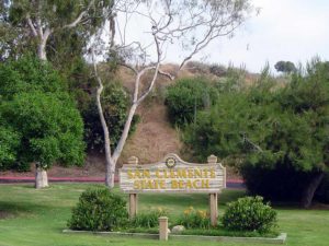
Access point: San Clemente State Beach.
How to get there: From Interstate 5 (San Diego Freeway), southbound traffic takes the Calafia exit. Northbound traffic takes the Cristianitos Road exit, goes left, then right on del Presidente to Avenida Calafia. The entrance to San Clemente State Beach is on Avenida Calafia one block from Del Presidente.
Other access:
Difficulty: Easy
Elevation gain/loss: 140 feet+.
Cautions:
Further information: For San Clemente State Beach and San Onofre State Beach call (949)492-0802.
Facilities: Water, restrooms, picnic tables and parking at San Clemente State Beach. Parking and chemical toilets at San Onofre State Beach.
Campgrounds: San Clemente State Beach has 157 campsites and hot showers. San Onofre State Beach has 22 I sites in Bluffs Campground and 162 sites and hot showers at San Mateo Campground 1.5 miles inland on Cristianitos Road.
Lodging: San Clemente has a variety of possibilities. San Clemente Hostel (949)492-2848 is three blocks from the beach and Amtrak station.
Points of Interest
In the News
Interested in contributing to this project?
Register to add new photos and information, update existing results and share your trip reports.