
Usage Notes

Legend: For details on the icons and trail colors, please click the legend icon on the map above.

Layers: Other layers are available. See the California Coastal Commission and Coastal Conservancy Completed Sections layer for the official completed trail segments. (About progress on the trail completion project.)
San Diego Section 2
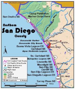
San Onofre State Beach to Oceanside Pier
Walking the beach on Camp Pendleton, a Marine Corps base, is highly restricted because of continual training exercises along the coastal bluffs and beaches and in the vast open spaces of the 130,000-acre base. However, riding or walking the bike path is routine. Whether you enter from the south through the main gate or from the north where the route passes a gate on Las Pulgas Road, the guard will ask you for a driver's license, vehicle registration and proof of auto insurance, even if you are on foot or bicycle, to be considered for access to the base. Helmets are required for bike riders.
The bike path starts at the end of Avenida del Presidente not far south of San Clemente State Beach near the Orange/San Diego County line. The path follows park roads through San Onofre State Beach, passing the San Onofre Nuclear Generating Station before reaching the long stretch of roadside campsites at Bluffs Campground. This CCT section starts at the south end of that campground.
This section begins at San Onofre State Beach's Trailhead 6 where the CCT route leaves the beach and joins the bike path. If you are walking, take note that much of the route is on a bike lane along roads. The bike path enters Camp Pendleton just past Trailhead 6 at a vehicle barrier. The path continues on the pavement of old Highway 101 beside the railroad tracks, following the blufftop through coastal sage scrub. At 2 miles you pass the creek flowing from the mouth of Horno Canyon in the steep hills just north. Before 2⅞ miles the train tracks pass under the nearby freeway.
At 3¾ miles your path also passes under the freeway, then parallels it on the inland side with the tracks again on your left. You reach Las Pulgas Road at 5 miles where you turn left and follow it past an entry gate. At 5⅜ miles you follow the bike path as it turns right on Stuart Mesa Road, dipping across Las Pulgas Canyon around 6 miles and passing leased farmland and military installations. You may see maneuvers involving troops, tanks and helicopters. You follow this long road across the gently rolling marine terrace, dropping back toward the freeway around 8 miles and crossing French Canyon, then more or less paralleling the freeway and the train tracks to around 9⅛ miles. After crossing Cockleburr Canyon at 10 miles, you follow Stuart Mesa Road over a rise, then descend along Newton Canyon on your left. After crossing the creek from Newton Canyon you dip across the Santa Margarita River at 11¾ miles where you're less than ten feet above sea level. Climb slightly to the road's end at 12¼ miles.
Turn right and follow busy Vandegrift Blvd. to Camp Pendleton's Main Gate at 14 miles, then continue along the road to cross Interstate 5. Turn left at the intersection just past the freeway to descend the hill to Harbor Drive South at 15⅛ miles. Just past the intersection you can walk along the walkway past the marina and dockside businesses. At the beach at the end of the marina, follow the road as it swings south and crosses the San Luis Rey River. Turn right on Ninth Street for a short block. When you reach The Strand you can either turn left and walk that concrete walkway ½ mile to the pier, or step out onto the beach and follow the tideline to the Oceanside Pier at 16¼ miles.
SUGGESTED ROUND TRIPS & LOOPS: Although the beach is restricted, Camp Pendleton does allow civilians to drive on the base and tour some of the historic and natural features during daylight hours. At the main gate produce a driver's license, vehicle registration and proof of insurance and a request a one-day pass. With the pass you'll get a self-guided driving map to the sites. Featured are a museum of tracked landing vehicles (closed Monday), historic sites including an adobe building from the Spanish mission period, and several natural sites including Rattlesnake Canyon.
Distance: 16¼ miles (26.1 kilometers).
Open to: Hikers, bicyclists.
Surface: Paved bike path.
Access point: San Onofre State Beach.
How to get there: From Interstate 5 (San Diego Freeway) take the Basilone Road exit for San Onofre State Beach. Follow the main road through the park south for 6 miles to Trailhead 6 just before the end of the road.
Other access:
Difficulty: Moderate
Elevation gain/loss: 180 feet+/320 feet-.
Cautions: Rattlesnakes find Camp Pendleton a good habitat. Take ample water for the long walk, especially in summer. Almost the entire route is on pavement. Helmets required on base for bike riders.
Further information: For San Clemente State Beach and San Onofre State Beach call (949)492-0802. Camp Pendleton Public Affairs (760)725-5011.
Facilities: San Onofre State Beach has restrooms, water and parking. Oceanside has all the urban amenities.
Campgrounds: San Clemente State Beach has 157 campsites and hot showers. San Onofre State Beach has 221 sites in Bluffs Campground and 162 sites and hot showers at San Mateo Campground 1.5 miles inland on Cristianitos Road.
Lodging: Nearest lodging is in San Clemente and Oceanside. San Clemente Hostel (949)492-2848, two sections north, is three blocks from the beach and the Amtrak station.
Interested in contributing to this project?
Register to add new photos and information, update existing results and share your trip reports.
The trail on the map seems to go all the way down to San Onofre State Beach at Agra. Then it seems to indicate that you join the bike path that goes through the Base.
Can you join the bike path from any point of the CCT or only at designated entry points? If the latter, does that mean that you have to go back after reaching Agra and join the bike path at the Avenida del Presidente?
Can you continue via the CCT? There doesn’t seem to be any fence preventing you from continuing down the CCT all the way through the Base. It would make sense if you cannot, but not sure why you can go all the way to Agra and not go on.
I am aware of the bike path through the Base and how it works. My doubts are mainly about the possibility of going down the actual CCT. Running/walking the bike path is not optimal.