
Usage Notes

Legend: For details on the icons and trail colors, please click the legend icon on the map above.

Layers: Other layers are available. See the California Coastal Commission and Coastal Conservancy Completed Sections layer for the official completed trail segments. (About progress on the trail completion project.)
San Diego Section 3
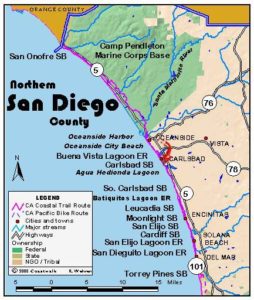
Oceanside Pier to South Carlsbad State Beach Campground
From Oceanside Pier all the way to South Carlsbad State Beach, the CCT route follows the beach at low to medium tides with a few short detours. The beach route, blocked at high tide in large part because the bluff has been armored with riprap to protect the houses built right on bluff's edge, also suffers sand starvation due to man-made blocks to natural sand replenishment processes. High tide forces the route on streets part of the time. We describe the low tide route and point out the potential detours along roads.
From the Oceanside Pier walk the tideline of the beach south to the riprap at ¾ mile. You can instead take The Strand, a paved walkway atop the bluff, for a few blocks. From the riprap, turn left and walk up lo Wisconsin Street and along it one block. Turn right and follow Pacific Street for two blocks, then turn right on Marron Street to return to the beach at one mile and follow it south.
At 1½ miles you reach Buccaneer Park with restrooms, parking, water and a short path along a small lagoon, Loma Alta Marsh. CCT continues along the tideline, with the beach in this area accessible from the ends of the streets. Farther down the beach before Buena Vista Lagoon, riprap again crowds the beach. When the beach is flooded, you can take an alternate inland route up Cassidy Street at 2⅛ miles. Add ½ mile to the total distance if you take this route. Walk up Cassidy Street, turn right on Pacific Coast Highway and follow it across the bridge over Buena Vista Lagoon. Take the first right onto Mountain View Drive which soon becomes Ocean Street. In a few blocks where the street turns to parallel the shoreline, return to the beach on a narrow path.
Our low tide route continues past Cassidy Street on the cobble beach, passing along the ocean side of Buena Vista Lagoon at 2¾ miles. If you get tired of the cobbles, at 2⅞ miles you can take the path up to Ocean Street (mentioned at the end of the alternate route above) and walk Ocean to its end al 3½ miles, where the parking lot at street's end marks the beginning of Carlsbad State Beach. Otherwise continue along the cobblestones of Carlsbad City Beach to Carlsbad State Beach at 3½ miles.
A massive two-tiered concrete seawall with walkways fronts the cobble beach at this northernmost of several units of Carlsbad State Beach. Take either of two walkways or the cobble beach to the other end of the seawall and another parking lot at 4 miles. Take the steps up to the main drag, Carlsbad Blvd. (Highway S21), and follow it across the bridge over Agua Hedionda (stinking water). At the south end of the bridge, you can either return to the beach or continue on the sidewalk. At 4¾ miles the beach ends at an inlet. Cut inland to walk the Carlsbad Blvd. bridge across the inlet, then return to the beach. East of Carlsbad Blvd. a giant power plant looms over the beach. The bluffs, although free from development, remain somewhat battered by the many informal paths from the street to the beach. Beginning at 5⅛ miles, houses line the bluffs.
If the beach is passable, continue down the beach at the base of the 40-foot tall cliffs. You reach a stairway coming down from the bluff at 5½ miles. You can either take the stairs and proceed along the route described below or continue on the beach.
If the beach is impassable at 5⅛ miles, then walk up to the highway sidewalk, turn right and continue to Cerezo Drive at 5½ miles. Adjacent to Cerezo Drive, take the path across the state park-owned marine terrace down to the bluff edge.
From there you can take the stairs down to the beach or walk the path along the undeveloped blufftop. If you stay on the blufftop, you reach a deep, narrow sandy ravine where you descend to the beach at 6 miles.
From there the CCT follows the enjoyable beach at the base of the eroding bluffs to section's end. Where the highway almost touches the beach, you can walk up to the pedestrian gate at the end of South Carlsbad State Beach campground and walk through the campground to the park entrance. The CCT continues down the beach to this section's end at the third set of stairs coming down top of the campground at 6½ miles. The campground entrance station is adjacent to the stairs.
SUGGESTED ROUND TRIPS & LOOPS: From Oceanside Pier walk the beach south or from Carlsbad Beach at Tamarack Avenue, walk it north for up to 4 miles, up to 8 miles round trip. From South Carlsbad State Beach campground, walk the beach north at low tide for up to 1½ miles, up to 3 miles round trip.
Distance: 6.1 miles (10.5 kilometers).
Open to: Hikers. Bicyclists on roads.
Surface: Beach, streets as alternate route at high tide.
Access point: Oceanside Pier.
How to get there: From Interstate 5 in Oceanside, take the Mission Avenue exit. The pier is one short block north of the end of Mission Avenue.
Other access:
Difficulty: Easy
Elevation gain/loss: 60 feet+/60 feet-. 110 feet+/ 110 feet- for high tide route.
Cautions: Portions of beaches may be flooded at high tide.
Further information: For Oceanside City Beach, call the Oceanside Department of Harbors and Beaches (760)435-4000, Carlsbad State Beach (760)438-3143.
Facilities: The Oceanside Pier area has picnic tables, restrooms, water and the usual urban amenities. Buccaneer Park has restrooms, picnic tables, parking and water. South Carlsbad State Beach has water, restrooms, and parking.
Campgrounds: South Carlsbad State Beach has 222 sites.
Lodging: Oceanside and Carlsbad have ample facilities.
Points of Interest
No individual points found.
In the News
Interested in contributing to this project?
Register to add new photos and information, update existing results and share your trip reports.