
Usage Notes

Legend: For details on the icons and trail colors, please click the legend icon on the map above.

Layers: Other layers are available. See the California Coastal Commission and Coastal Conservancy Completed Sections layer for the official completed trail segments. (About progress on the trail completion project.)
Orange Section 7
Doheny State Beach to San Clemente State Beach
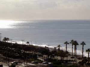
Doheny State Beach was established in 1931 when this area was still rural. For years coming to Doheny was a trip to a wilder place than it is today. Now urban growth crowds both Doheny and San Clemente state beaches, detracting from the sense of open space a park should have. Still, both parks offer camping and a fine beach experience. Between the two state beaches, the CCT mostly follows the beach with a few high-tide detours. This hike and Orange County's Coastal Trail end at San Clemente State Beach about a mile before the San Diego County line. Before questing forth on this great beach walk, be sure to check out the Visitor Center inland across the wide expanse of lawn near the entrance station. The harbor jetty calms the surf along the beach here, making it a good place for family swimming or novice board surfers. Much of the route is especially subject to erosion on the beach and bluffs, with subsequent damage to real estate because poor planning allowed building in hazardous areas.
From the parking lot, walk down to the tideline of the nearby beach of white sand. Our CCT route proceeds down the beach to San Juan Creek at ¼ mile. If it's too deep to cross, walk inland briefly to the main park road, cross the creek and return to the beach through the campground. San Juan Creek features a bike path running inland on the levee to the town of San Juan Capistrano.
CCT continues along the sandy beach. Beyond one mile you leave Doheny Beach for Capistrano Beach, essentially the same broad white strand with palisades rising 140 feet tall beyond the train tracks and El Camino Real, which run along the top of the beach. From 1⅜ miles a solid row of houses line the top of the beach. When you reach a gap in the houses around 2⅞ miles, you've reached Poche Beach. Walk its tideline south to the park's end around 3¼ miles.
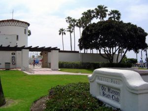
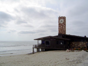
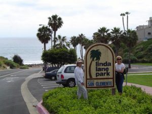
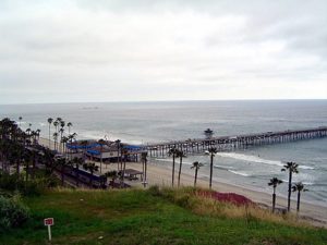
About ⅛ mile further a trailer park sits atop riprap and fill dumped right on the beach, making passage difficult at high tide. If the tide is low enough, walk the tideline of the beach along the base of the riprap. If you can't get past, then carefully cross the train tracks, walk south along El Camino Real, and return to the beach at the other end of the trailer park around 4 miles. Soon you come to a small park beside the Ole Hanson Beach Club, then pass the only Amtrak station (Capistrano Beach) where you can depart the train directly onto the beach. Continue along the tideline of what's now called San Clemente City Beach, an ample beach of mostly brown sand. After another good stretch of beach at the base of eroded bluffs, you reach Linda Lane Park at 4½ miles followed by popular San Clemente Pier at 5 miles. The pier offers a good place to take a rest and check out the local scene before continuing. San Clemente retains some sense of an older California.
Beyond the pier the beach stretches wide and white for another 1⅝ miles to San Clemente State Beach. Walk the tideline south. You can tell you have arrived at the state park around 6¼ miles because development on the bluff abruptly ends at the park's border. The soft, highly erodible sandstone cliffs and native vegetation are picturesque, suggesting what the region looked like before development. The railroad tracks shored up by riprap at the base of the cliffs blight the scene. Continue along the wild beach, watching for the lifeguard station on the bluff and a tunnel under the tracks that mark the path at section's end. You find the path up the bluffs at 6⅝ miles. The wide path ends in ⅜ mile at the day-use area on top of the cliffs, while the CCT continues along the beach, described in San Diego Section 1.
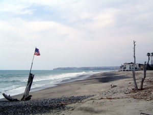
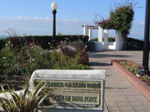
SUGGESTED ROUND TRIPS AND LOOPS: From San Clemente State Beach, walk down to the San Diego County line at San Mateo Point and return, 2¼ miles round trip. Before the point a small white building sits on the low bluff. This gazebo of Nixon's Western Whitehouse is purported to be Nixon's retreat from Pat's insistence that he not smoke cigars in the main house.
Distance: 6⅝ miles (10.7 kilometers).
Open to: Hikers.
Surface: Beach.
Access point: Doheny State Beach.
How to get there: From Interstate 5 take the Highway exit to Dana Point. Go north about 1.5 miles, turn left on Dana Point Harbor Drive, then immediately turn left into the Doheny State Beach entrance.
Other access: Capistrano Beach, Poche Beach, Linda Lane Park, San Clemente City Beach.
Difficulty: Easy
Elevation gain/loss: Negligible.
Cautions: The busy coastal railroad tracks parallel the beach so use caution when crossing. Riprapped beaches may be flooded at higher tides.
Further information: Doheny State Beach (949)496-6171, for Poche Beach and Capistrano Beach call the South Beaches Operations Office of Orange County Harbors, Beaches and Parks (949)661-7013, for San Clemente City Beach call the San Clemente Department of Marine Safety (949)361-8219, for San Clemente State Beach call Orange Coast District, California State Parks (949)492-0802.
Facilities: Picnic tables, water, restrooms, parking at Doheny State Beach, San Clemente Pier and San Clemente State Beach.
Campgrounds: Doheny State Beach has 120 sites and San Clemente State Beach has 157 sites, with both campgrounds having hot showers.
Lodging: Accommodations abound throughout the region. San Clemente Hostel (949)492-2848 is three blocks from the beach and the Amtrak station.
Points of Interest
In the News
Interested in contributing to this project?
Register to add new photos and information, update existing results and share your trip reports.