
~Ken McKowen
Distance: One can spend a few hours or a leisurely day exploring the slough by kayak and/or hiking the trails in the Elkhorn Estuarine National Research Reserve
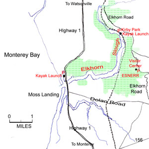
Location: Elkhorn Slough and surrounding coastal wetlands are in Monterey County, just east of the Pacific Coast Highway, roughly midway between Santa Cruz and Monterey; it is also easily accessible from Highway 101. There are two public kayak launch sites as indicated on the map. Kayaks can be rented in Moss Landing. The Reserves Visitor Center is located at 1700 Elkhorn Road, Watsonville, CA 95076. Phone (831) 728-2822. Directions to Reserve Visitor Center, trails & wheel-chair access: From Highway 1 at Moss Landing, turn onto Dolan Road and drive approximately 4.6 miles to Elkhorn Road. Turn left and drive another 2 miles to the visitor center entrance on the left.
Fees: Entry to the visitor center and picnic grounds is free. For the trails, none for anyone with a valid California hunting or fishing license; otherwise a small fee for those age 16 and over.
Hours:The Reserves grounds and Visitor Center are open Wednesday through Sunday, 9 am to 5 pm.
Hazards: Respect the wildlifegive them ample room. Do not leave the trails or trod the wetlandsthey are fragile. Description:For a different view of the waterways and their wildlife, kayaking the estuary is extremely popular. Most of the estuary’s channels are accessible, as are many of the small side channels, at least at high tide. It’s always important to be aware of the tides. Being caught on the wrong side of a shallow area that quickly becomes a mud flat as the tide races out is not only embarrassing, but a major pain when trying to tow a kayak out across deep mud that feels like it’s trying to suck your feet off your ankles. You might want to time your trip so that the afternoon winds will be at your back. It’s equally important to remember that tidal flows around the harbor can create problems when trying to negotiate under the Highway 1 bridge, in addition to difficulty maneuvering around the commercial and private boat traffic that moves in and out of the Moss Landing Marina.
There are only two places to launch kayaks in the estuary. Kirby Park has a small launch ramp and is located north of the Elkhorn Slough Visitor Center on Elkhorn Road. The second launching facility is the Moss Landing Harbor District launch ramp. While kayaking is a great way to experience the wildlife, it’s also important to stay back at least 200 feet from the harbor seals, California sea lions, and otters that are common in the slough. If the animals you see begin to appear nervous, then you’re getting too close.
California’s coastal estuaries and marshes are some of the most prolific producers and supporters of wildlife in the world. The 3,000 acres of marsh and tidal flats and the 7 miles of main water channel that comprise much of Eikhorn Slough National Estuarine Research Reserve and the adjacent Moss Landing Wildlife Area are home, either permanently or as a seasonal sanctuary, to more than 400 species of invertebrates and 80 species of fish. There are 267 species of birds on the estuary’s bird list. Yet, the unfortunate fact is that during the past century, nearly 90 percent of these same rich wetlands in California have been filled, drained, or in other ways destroyed. Even Elkhorn Slough has seen extensive commercial operations, such as the 200 acres of commercial salt ponds that were in production from the early 1900s until 1974. Today the ponds have been reclaimed and serve a much more valuable role as rich feeding grounds for dozens of bird species and a summer resting ground for the endangered brown pelican.
The salt flats aren’t the only areas of the slough that have been restored. Much of the marshland was diked and drained during the earlier part of the century and used as grazing land for the Elkhorn Dairy operation. Two of the old barns remain on the property, and are now home to bats, barn owls, and other wildlife. Most of the dikes are gone, at least those that were able to restrict the ebb and flow of seawater and fresh water. The land that has been reflooded today serves as a valuable research area where the success of such wetland restorations can be studied and new and better techniques developed.
Several trails wind through the estuary, most starting near the visitor center. And the visitor center is a great first stop. The exhibits are both enlightening and entertaining. The gigantic foot of a great blue heron, stepping down through the center’s ceiling onto an equally oversized model of an underwater mud flat, its beak grasping a fish, is quite fascinating. The model also provides a great look at the creatures that thrive in the water and under the mud flats of the estuary. For wildflower enthusiasts, another exhibit displays a sampling of the flowers and plants that are most likely to be seen near the trails. The plants and wildflowers found here during any season are as varied and rich as the bird life. Sticky monkey flower (Mimulus aurantiacus) and wild buckwheat (Eriogonum nudum) are found in the drier areas, along with fennel (Foeniculum vulgare) and Socrates’ last drink, poison hemlock (Conium maculatum). Closer to the edges of the marsh are mugwort (Artemisia douglasiana), pickleweed (Salicornia virginica), and salt marsh dodder (Cuscuta sauna var. major). About 90 percent of the vegetation covering the salt marsh is pickleweed, one of several plants that have adapted to the high concentrations of salt water. Leaves, which store the excess salt absorbed during the growing season, are dropped during winter. Along the upper trails, dark green swathes of oak woodland, with their coast live oak (Quercus agrifolia), contrast with patches of open grasslands. And to reinforce the need to remain on the trails some areas are bordered by thick hedges of poison oak (Toxicodendron diversilobum).
The visitor center also provides free bird lists that include the seasons when the different birds are most likely to be seen. Summer brings large numbers of brown pelicans (Pelecanus occidentalis) to the mud flats, along with numerous species of shorebirds searching the wet mud for food. The prominent white, great egrets (Casmerodius albus) are here year-round, as are the great blue herons (Ardea herodias). As an important winter stopover along the Pacific Flyway, Elkhorn Slough provides refuge for Canada geese (Branta canadensis), green-winged teal (Anas crecca), pintails (Anas acuta), gadwalls (Anas strepera), American widgeon (Anas americana), common goldeneyes (Bucephala clangula), and ruddy ducks (Oxyura jamaicensis). Jaegers (Stercorarius pomarinus), gulls (Larus sp.), terns (Sterna sp.), and a plethora of more terrestrial birds are commonly seen by bird watchers.
The Long Valley Loop Trail is a short (0.8 mile) loop that leaves from the visitor center, passes through an area of oak woodland, then drops down a short hill and follows along one of the fingers of a waterway known appropriately as Five Fingers.
Most of the Five Fingers Loop Trail stays on the hillside for great views looking toward Monterey Bay in the distance. The trail can be picked up from the Long Valley Loop or directly via the short, paved trail that connects with the visitor center. While anywhere within the estuary is great for bird-watching, there is a wonderful blind that has been constructed in the treeline at about the halfway point in the loop. It overlooks the old salt mining area and provides cover for photographers and their equipment. It’s also large enough to handle several people. The entire loop is about 1.2 miles.
The South Marsh Loop is a great trail (about 2.2 miles) that quickly drops down from the visitor center, passes the old Elkhorn Farm barns, and meanders around the south marsh area. Most of the walking is relatively level.
The Wheelchair Trail is a paved trail that heads west for maybe 100 yards from the visitor center (the same trail that connects with all the other dirt trails), and ends in a paved circular area with two spotting scopes that overlook the majority of the estuary waters.
Adapted from the Highroad Guide to the California Coast (1st edition, Wilderness Press) by Ken McKowen. All rights reserved. Map: Susana Nierlich. Photo: Courtesy of Greg Hofmann, Elkhorn Slough Foundation.
Ken McKowen was for 30 years a California State Parks Rangermost recently managing, state-wide, its trails program. This included serving as a member of the Working Group to make plans for completing the California Coastal Trail. Now retired, his third book, written with his wife, Dahlynn, has appeared. Check out: Best of Califorinia’s Misssions, Mansions, and Museums.
Links:
Elkhorn Sough Reserve visitor information
For paddlers and hikers information
For birders
Natural history, plants and animals