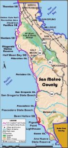
San Mateo Section 7
San Gregorio State Beach to Pescadero State Beach
At low to medium tides, this piece of coast offers some fine walking on isolated beaches at the base of steep cliffs. Although the highway is near, you can't see it for the 100-foot-high cliffs, and the crashing surf blocks most highway sounds. At high tide, you must walk the highway or wait for the tide to recede. State Parks owns the beach and bluffs west of the highway from San Gregorio Beach all the way to Pescadero Beach, but the bluffs have no official trail and the marine terrace is deeply cut by ravines.
From the San Gregorio State Beach parking lot, drop down to the beach south of San Gregorio Creek. The beach from here to Pomponio Beach is almost always open except at the highest tides. Since the beach backs against high cliffs, don't go unless you're sure of the tides. If you have doubts, don't do it. CCT follows the beach south. Since most people stay near the parking lots, you'll probably find solitude quickly. Walk an open beach for ¾ mile. Just before you reach Pomponio Beach, big rocks on the beach may block your way at very high tides. If it's blocked, find a safe way up the bluff to the highway and walk the shoulder. Otherwise, walk Pomponio Beach to Pomponio Creek around one mile.
South of Pomponio Creek, rocks, cliffs and surf block the beach, so you must turn east and walk the highway shoulder. It climbs a hill, then drops across Long Gulch. Part way up the next rise around ½ mile from the Pomponio Beach parking lot, look for a casual trail west across the bluffs before 3¼ miles. It's marked by three creosote posts with a barren patch of ground behind them. Unless it's high tide, take this trail down toward the beach. In about ⅛ mile the trail drops into a small gully, crossing the creek on a short, narrow board bridge, then heads for the beach. Descend the final fifteen feet to the beach by handholds and steps cut into the sandstone. It's fairly safe if you're careful, unless you have a fear of heights. You come to an isolated beach with few visitors. Unless the tide is high, walk the beach south all the way to Pescadero Beach.
You reach the first parking area for Pescadero Beach at 4½ miles. Continue down the beach to Pescadero Creek. Follow the creek up to the highway bridge. Walk the pedestrian path on the bridge to the parking lot on the west side of the highway and section's end at 4¾ miles. You can see Pescadero Marsh across the highway.
SUGGESTED ROUND TRIPS & LOOPS: From any of the four state park parking lots, you can take short strolls to explore the beaches. Pescadero Marsh, one of the most important freshwater/brackish coastal marshes in California, has three short trails into it. It's an important stop on the Pacific Flyway and home to many resident birds.
One trail starts across the highway from the north parking lot. Another follows Pescadero Creek's north bank under the highway bridge, and the third starts from Pescadero Road.
Distance: 4¾ miles (7.6 kilometers).
Open to: Hikers. Bicyclists on road.
Surface: Beach, highway shoulder.
Access point: San Gregorio State Beach.
How to get there: Turn west off Highway just south of Highway 84/La Honda Road into San Gregorio State Beach parking area.
Other access: Pomponio State Beach.
Difficulty: Easy
Elevation gain/loss: 160 feet+/300 feet-.
Cautions: Don't get trapped by rising tides. Use caution on the tricky, short descent to the beach.
Further information: San Mateo Coast State Beaches (650)879-2170.
Facilities: Chemical toilets at San Gregorio, Pomponio, and Pescadero State Beaches.
Campgrounds: San Mateo County Memorial Park 10 miles east of Pescadero Beach on Pescadero Road has many sites.
Lodging: Pigeon Point Lighthouse Hostel (650)879-0633 is at end of next section. Half Moon Bay to the north and Davenport to the south have lodging.
Interested in contributing to this project?
Register to add new photos and information, update existing results and share your trip reports.


