
Usage Notes

Legend: For details on the icons and trail colors, please click the legend icon on the map above.

Layers: Other layers are available. See the California Coastal Commission and Coastal Conservancy Completed Sections layer for the official completed trail segments. (About progress on the trail completion project.)
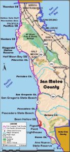
San Mateo Section 8
Pescadero State Beach to Pigeon Point Lighthouse
The California coastline is ever changing as one proceeds down the coast. The previous section was all rolling hills and steep cliffs. This one is on a gentle marine terrace with low bluffs overlooking an extensive area of tidal rocks. Much of this walk follows the highway through agricultural land, presenting many opportunities to explore the intertidal zone and some pocket beaches.
From the Pescadero Beach south parking lot, walk the highway shoulder south. For the 2 miles to Pebble Beach, the highway is on the low bluff, offering many places to drop down to the rocky tidal zone and explore. While the rugged tidal zone makes for slow going, if you're up to it, it can be negotiated at low to medium tide.
At Pebble Beach, a short side path from the parking area drops to the beach, SO named because of its colorful, pea-sized quartz rocks. You'll also find a curious rock formation called tafoni. The Coastal Trail south from the parking area follows the nature trail right along the edge of the bluff. Since State Parks is restoring this coastal bluff plant community, hikers should stay on the path. Watch for harbor seals resting on the offshore rocks.
At 2¾ miles the nature trail ends at another pocket beach, Arroyo de los Frijoles, or as it is marked, Bean Hollow. You can explore the tidal area south from Bean Hollow Beach for about 2 miles to Bolsa Point but may not be able to reach Lighthouse Road. Since a hiker may be trespassing when he steps onto the bluff from the tidal zone, the Coastal Trail returns to the highway.
For now the CCT follows the highway shoulder south from Bean Hollow Beach. As you walk south, the Pigeon Point Lighthouse, second tallest on the west coast at 115 feet, comes into view. The highway rolls past Bolsa Point around 4¾ miles, then dips across a creek. At 5¼ miles you want to turn right onto Lighthouse Road. You can reach the sandy beach across the bluff. Walk the narrow road along the bluff between the highway and the shore. You'll see some informal paths along the bluff edge. Artichoke fields are east of the road and the lighthouse looms large as you approach it. The section ends at the hostel entrance at 6 miles. A fence separates the grounds of the lighthouse and hostel. The hostel closes during the day, reopening at 4:30. The lighthouse merits a look, perched above the churning ocean on picturesque Pigeon Point.
SUGGESTED ROUND TRIPS & LOOPS: From either Pebble Beach or Bean Hollow, take the nature trail and return, 1½ miles round trip.
Distance: 6 miles (9.7 kilometers).
Open to: Hikers. Bicyclists on road.
Surface: Beach, trail, highway shoulder, road shoulder.
Access point: Pescadero Beach.
How to get there: Turn west off Highway 1 about 15 miles south of Half Moon Bay and .25 mile north of Pescadero Road into Pescadero State Beach south parking lot.
Other access: Bean Hollow Beach.
Difficulty: Easy
Elevation gain/loss: 60 feet+/40 feet-.
Cautions: The hostel closes during the day from 10 AM to 4:30 PM.
Further information: San Mateo Coast State Beaches (650)879-2170.
Facilities: Chemical toilets at Pescadero Beach. Water at Pigeon Point Lighthouse.
Campgrounds: Butano State Park in hills east of section has camping. San Mateo County Memorial Park 10 miles east of Pescadero Beach on Pescadero Road has many sites.
Lodging: Pigeon Point Lighthouse Hostel (650)879-0633. Half Moon Bay to the north and Davenport to the south have lodging.

Interested in contributing to this project?
Register to add new photos and information, update existing results and share your trip reports.