
Usage Notes

Legend: For details on the icons and trail colors, please click the legend icon on the map above.

Layers: Other layers are available. See the California Coastal Commission and Coastal Conservancy Completed Sections layer for the official completed trail segments. (About progress on the trail completion project.)
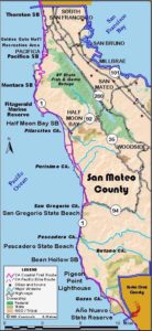
San Mateo Section 9
Pigeon Point Lighthouse to Año Nuevo State Reserve
Although half of this section follows the shoulder of Highway 1, the highway stints are interspersed with pleasant walks on beach, dunes, bluffs and sleepy secondary roads. The section's best part falls smack in the middle where from Gazos Creek to Cascade Creek you'll walk a splendid little-used beach past intricately etched pockets of sandstone at the base of low cliffs, climb through dunes over rocky Franklin Point, then wind through more dunes along natural bluffs to overlook the rocky tidal zone of Año Nuevo Reserve, where elephant seals have full access and hikers are restricted or prohibited depending on the time of year. If you stay overnight at Pigeon Point Lighthouse Hostel, the thundering surf will lull you into a deep sleep, especially if you've had a soak in the hot tub there.
From the lighthouse, walk the narrow road east to the highway around ⅛ mile. Heading south, you can walk the low, vehicle-damaged bluff to about ⅜ mile, or just walk the wide shoulder of the highway. The rutted bluff soon gives way to agricultural fields. Around 1¼ miles, a farm produce stand beckons you to buy some fresh food. Continue on the shoulder, passing a mushroom farm east of the highway.
At 2½ miles turn right into the Gazos Creek Coastal Access where parking and a privy are available. Take the short trail through a thick patch of poison oak down to the beach, leaving the highway behind. To the south Franklin Point juts out to sea. Walk the beach towards the point. In summer you can walk to the end of the beach on the sand. In winter, part of the sand washes away, so around 3 miles you must take a short trail up through the dunes. Where a small creek reaches a widening sandy area, look for the white plastic pipe marking the trail into the dunes. Alter about ¼ mile the trail returns to the beach. Follow it south past eroded pockets of sandstone at the base of the low cliffs.
Just before Franklin Point at 3¾ miles, watch for the unmarked but wide and distinct trail heading up into the dunes. Stay on the most-used track, following it as it winds through dunes, willows and poison oak. The trail comes to rocky Franklin Point overlooking the tidal rocks, then winds through more dunes.
Around 4¼ miles the trail forks at the ravine of Whitehouse Creek. The left fork turns inland, leading to a parking lot on the highway. Turn right and descend the trail into the ravine, across the creek and out to the beach.
During most tides the beach south is passable. If it's not, ascend the trail on the south side of the ravine and walk the blufftop south to Cascade Creek. Otherwise, walk the beach south to Cascade Creek at 5⅛ miles. Unless the creek is high, it doesn't cascade, but mostly disappears under the sand as it flows out of the marsh up from the beach.
As inviting as the rocks south beyond the beach look, they are off limits.
From here to Año Nuevo Point the shoreline and the land about ½ mile inland from it are restricted breeding grounds of the Northern Elephant Seal (See feature article in the next section). A few hundred feet north of Cascade Creek, find and take the path climbing up onto the marine terrace. This trail meets the blufftop trail and leads to Highway 1 and a parking area at 5¾ miles. Turn right and walk the highway shoulder for about 2 miles, passing the historic Año Nuevo Ranch. Beyond 7¾ miles, find the driveway into the parking lot for Año Nuevo State Reserve. Walk down this road to the visitor center and section's end at 8¼ miles where you will find water and privies.
SUGGESTED ROUND TRIPS & LOOPS: From the Gazos Creek Coastal Access walk south on the beach, across Franklin Point and down to the beach north of Año Nuevo Point. Turn around at Cascade Creek and return, a pleasant 6 miles round trip.
Distance: 8¼ miles (13.3 kilometers).
Open to: Hikers. Bicyclists on road.
Surface: Beach, trail, highway shoulder.
Access point: Pigeon Point Lighthouse.
How to get there: Turn west off Highway 1 about 20 miles south of Half Moon Bay onto Pigeon Point Lighthouse Road and go .75 mile to hostel.
Other access: Gazos Creek Coastal Access.
Difficulty: Moderate
Elevation gain/loss: 80 feet+/60 feet-.
Cautions: Beware of the poison oak at Franklin Point.
Further information: Año Nuevo State Reserve (650)879-2025.
Facilities: Water at Pigeon Point. Chemical toilet at Gazos Creek. Water, restrooms, picnic tables, visitor center at Año Nuevo State Reserve.
Campgrounds: Butano State Park, about 4 miles east off Gazos Creek Road, has campsites in a beautiful redwood forest.
Lodging: Pigeon Point Lighthouse Hostel (650)879-0633. Davenport and Santa Cruz to the south and Half Moon Bay to the north have lodging.

Interested in contributing to this project?
Register to add new photos and information, update existing results and share your trip reports.
From Bob, a walk leader on this section:
Regarding that stretch of the coast between Pigeon Point lighthouse and Gazos Creek State Beach: Bottom line, you’re going to have to walk much of the CCT along hwy 1. The satellite view on Google earth is good.
Going South from the lighthouse:
There’s a loop trail from the lighthouse that is blocked at the gulley before it becomes Pigeon Point Regional Park, (PPRP).
You have to get on Pigeon Point Rd walking toward hwy 1 to cross the gulley. You can then cross car barrier into PPRP. PPRP is divided into two sections by another gulley the would be challenging to cross but it’s OK to walk both sides.
The lands South of PPRP are well signed “No Trespassing”, and marked as “Conservation Land” belonging to Peninsula Open Space Trust which can be reached at (650) 854-7696, http://WWW.OPENSPACETRUST.ORG
All of the coastal access roads West from hwy 1 before Gazos Beach are also marked “No trespassing”.
From Gazos Beach, at low tide you can go about a half mile North on the beach but no way to access HWY 1 from there, even on what’s marked as “Gazos Creek State Beach” on Google is not accessible with “No Trespassing” signs along the North side of the parking lot.