
Usage Notes

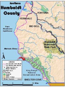
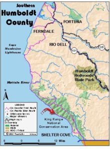
Legend: For details on the icons and trail colors, please click the legend icon on the map above.

Layers: Other layers are available. See the California Coastal Commission and Coastal Conservancy Completed Sections layer for the official completed trail segments. (About progress on the trail completion project.)
Humboldt Section 14
Smith-Etter Road to Shelter Cove, King Range National Conservation Area
CCT continues along the King Range Lost Coast. Only fit hikers should access this section from the locked gate on Smith-Etter Road. To do so, hikers must descend nearly 2500 feet in elevation in only 3¾ miles. Most strenuous of all is climbing out the same way. The easiest way to experience this section is to hike north from Shelter Cove, retracing your steps at the end of your visit.
If you're starting from the Smith-Etter Road rather than walking the Lost Coast from the Mattole River, follow the jeep track northwest, climbing [or ½ mile. After contouring atop Kinsey Ridge, descend steadily with grand coastal views. Descend the ridge's north face for ½ mile, then return to the ridge and descend steeply by long switchbacks. By 3 miles you reach the road's westernmost bend high above Oat Creek. Descend steeply as the wilderness coast stretches magnificently below. Switchback right at 3¼ miles and descend by five steep switchbacks to the coast to meet CCT. The mileage starts again from zero.
Where Smith-Etter Road meets CCT at the base of Kinsey Ridge, Lost Coast hikers follow a two-wheel track southeast. It crosses the broad, gravelly wash of Kinsey Creek in ¼ mile. Follow the track through grasslands below steep bluffs. At one mile your track passes west of the Etter cabin and a private inholding.
The road gradually fades to a sandy track as the headlands narrow at the base of steep grasslands rising to 3010-foot Hadley Peak, barely a mile from the Pacific. Come to Hadley Creek, also known as Big Creek, at 1⅝ miles. Dense forest in the deep, shady canyon shelters pleasant campsites within ⅝ mile of the beach.
CCT continues southeast in loose sand along a narrow beach. Around 1⅞ miles you pass high dunes backed against a steep a grassy hill. A trail climbing the steep headlands just south provides better walking than continued slogging in sand. At 2 miles a slide covers the faint double track, but a narrow trail continues. Back on grasslands as the trail turns vague, stay high on the headlands below steep bluffs. After crossing a watercress-choked stream at 2⅛ miles, your trail descends to a gently rolling grassland, soon returning to an obvious dirt road.
After crossing a small creek at 2¾ miles, you reach Big Flat which stretches more than a mile along the coast. A firm road provides easy walking past numerous Indian shell middens. As Big Flat broadens to its widest point, the road draws away from the shore. At 3¼ miles your track meets a landing strip used by residents of the house ahead. Approaching the canyon of Big Flat Creek, watch for timber rattlesnakes that live on the flat and in the rocky wash of the creek.
After paralleling the runway, your trail forks. The road continues along the landing strip, then heads into the canyon where the most protected campsites lie among the trees alongside the broad gravelly wash. The rugged Rattlesnake Ridge Trail continues up the canyon, climbing 3400 feet in 4⅝ miles to the Kings Crest Trail west of Kings Peak.
CCT forks to the right at the junction, crossing the runway and following the edge of the willow and alder thicket near the beach. It passes two camps at 3¾ miles, the second with a driftwood shelter. From here you can look up Big Flat Creek Canyon to 4087-foot Kings Peak, the highest point along the coast north of Big Sur. The trail becomes vague crossing the broad wash of Big Flat Creek. Aim to the right of the trees on the far side and watch for rattlers.
Climb slightly to Miller Flat, broader and more wooded than Big Flat. Several campsites lie near the trail with more sheltered camps in the forest to the northeast. Your trail turns east, climbing gradually on the broad flat until a short descent at 4⅝ miles drops to the beach, now heading almost east.
Follow the beach along the base of steep bluffs. On your right lie many offshore rocks and tidepools. Beyond a small unmapped creek, the beach becomes very rocky. Round a small point at 5⅜ miles as the beach narrows.
Ahead lies a stretch of coast where passage may be blocked at tides above +4.0 feet. The rugged cliffs on your left have many small creeks, seeps and springs, supporting hanging wildflower gardens in spring and summer. The narrowest point lies just before Shipman Creek at 5¾ miles. Beautiful Shipman Creek has camps in the driftwood above its mouth. At low tide you can visit tidepools to the west. You're 6¼ miles from Shelter Cove.
Continue down the broad beach. At 6½ miles you cross a small creek which plunges 1600 feet in its ¾-mile course. Offshore lies the deep submarine trench of Delgada Canyon, 450 feet deep only ½ mile from shore. Just around a point the beach turns rocky and narrow. Reach Buck Creek at miles, passing the Buck Ridge Trail just beyond (ascends 3300 feet in 2½ miles to Kings Crest Trail). Many more creeks tumble down the cliffs on your way to Gitchell Creek at 8½ miles. A pleasant campsite sits beside its mouth. The off-road vehicle users once allowed this far north on the beach from Shelter Cove have now been excluded.
After a mile of sandy beach, you can follow a dirt road along the bluffs. At 10½ miles the road returns to the beach at the wooded canyon of Horse Mountain Creek. Big rocks lie along the beach at 10⅞ miles before another steep creek. The beach broadens and turns south, heading for Shelter Cove atop Point Delgada. Walk the beach below towering Kaluna Cliff which reaches its steepest pitch around the creek at 11½ miles. Cross Telegraph Creek at 12 miles and come to the Black Sands Beach parking area. The old parking area was destroyed by storm surf. It has now been replaced by a new lot up a gully above the beach at the end of Beach Road, just southeast of the former lot.
ALTERNATE ROUTE: The King Range high route follows the western end of Telegraph Ridge Jeep Trail and Smith-Etter Road to the north end of Kings Crest Trail. Some maps show it as North Slide Peak Trailhead, 1½ miles from the gate on SmithEtter Road where it meets Telegraph Ridge Road, or 7½ miles from Smith-Etter Road's eastern end. From there the high route follows Kings Crest Trail south. You have two chances to return to the coast: the Rattlesnake Ridge Trail, 3 miles from the north trailhead, descends 4⅝ miles to Big Flat, or the Buck Ridge Trail at 10 miles descends 2½ miles to the mouth of Buck Creek. Otherwise, when Kings Crest Trail ends in 10⅞ miles at Saddle Mountain Road, follow the road 3⅝ miles, then go right on Horse Mountain Road (aka Kings Peak Road) for 6½ miles to paved Shelter Cove Road, part of Humboldt County Section 15.
SUGGESTED ROUND TRIPS & LOOPS: This steep, rugged country isn't particularly suitable for day hikes, but if you're ready for demanding overnight loops several possibilities exist. You can descend Smith-Etter Road, walk the coast north to ascend Spanish Ridge Trail, then return south by Telegraph Ridge Jeep Trail for the easiest 13mile loop. More challenging possibilities include loops on Rattlesnake Ridge or Buck Ridge Trail to the south or Cookie Creek Trail to the north. If you want to sample this part of CCT without a demanding trek, the best choice follows the beach north from Black Sands Beach. If you start early, you can make the all-day 12½-mile round trip hike to Shipman Creek.
Distance: 12 miles. Add 3¾ miles to reach CCT from access point.
Open to: Hikers, equestrians.
Surface: Beach, dirt road, trail.
Access point: Smith-Etter Road.
How to get there: Leave Highway 101 north of Weott at South Fork/Honeydew exit, Milepost 36. I from north, Milepost 35.5 from south. Follow Mattole Road west 23 miles to Honeydew (store and gas). Go left 1.5 miles, then turn right on Smith-Etter Road. Drive 9 steep, winding, rough and unpaved miles to locked gate. From there it's a 3¾-mile hike down Smith-Etter Road to CCT.
Other access:
Difficulty: Moderate
Elevation gain/loss: Minimal for CCT. Depends on route you take. From Smith-Etter Road gate to CCT: 140 feet+/2460 feet-.
Cautions: Smith-Etter Road may be closed from November to March, and anytime a landslide blocks it. Call BLM before you go. Watch for timber rattlesnakes, especially around canyons. Beach north of Shipman Creek may be impassable at high tide.
Further information: Bureau of Land Management (707)825-2300 or 468-4000.
Facilities: None.
Campgrounds: Primitive camping allowed along route. Honeydew Creek Tenting Area near start of Smith-Etter Road makes a good staging area. Private Shelter Cove Campground is near south end.
Lodging: Mattole River Resort is near Honeydew. Shelter Cove has several lodgings.
Points of Interest
No individual points found.
In the News
Interested in contributing to this project?
Register to add new photos and information, update existing results and share your trip reports.