
Usage Notes

Legend: For details on the icons and trail colors, please click the legend icon on the map above.

Layers: Other layers are available. See the California Coastal Commission and Coastal Conservancy Completed Sections layer for the official completed trail segments. (About progress on the trail completion project.)
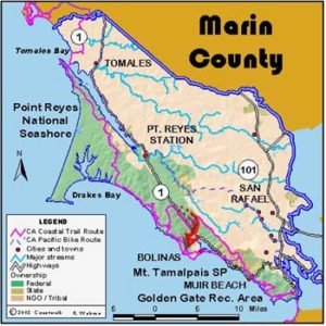
Marin Section 4
Hostel to Glen Camp, Point Reyes National Seashore
When you leave the hostel heading south on CCT, you are leaving civilization for two days. For the next 16 miles to Palomarin (Sections 4 and 5), the trail traverses the 25,370-acre Phillip Burton Wilderness Area. This wilderness leg of CCT is marked as "COAST TRAIL," a name chosen in the 1960s before the idea of a California Coastal Trail was born. Whatever you call it, the trail explores some of the most dramatic terrain on the entire California coast. Unless you intend to hike the 16 miles in one long day, you must reserve a site at Wildcat Camp or Glen Camp and bring a backpack.
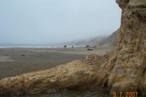
From the hostel walk west on the road for ⅛ mile to find the Coastal Trail. Head west to descend along a creek with thick marshy riparian forest. By 1⅜ miles the sound of breakers becomes evident as you swing south and parallel the beach behind the dunes. After passing a marshy lagoon on the right, your alternative to the trail here is to find a gap through the dunes and walk the beach. If you do, watch for the big eucalyptus tree marking where you must return to the trail at Coast Camp. Coast Camp has a pleasant beach with curious rock formations jutting into the surf farther south. The trail reaches Coast Camp 2⅞ miles from the hostel, about the same as the beach route. Coast Camp has water and chemical toilets.
After you pass the group camp, climb to the marine terrace. The trail follows the terrace, meandering through small ravines on the way to Arch Rock. A good side trip at 4⅛ miles descends to geologically unique Sculptured Beach, ⅜ mile round trip. Continue along the terrace above the spectacular coast, at 7¼ miles meeting the popular Bear Valley Trail which leads 4½ miles east to the Bear Valley Visitor Center. Another good short side trail on the right leads to Arch Rock which thrusts out into the surf, affording sweeping views north and south and a good place for lunch.
The Coastal Trail crosses Coast Creek and starts climbing, the beginning of a stiff and steep 800-foot ascent on an eroded trail for about 1⅜ miles. Great views reward you. Climb past a spur trail at 8⅜ miles, and around 9 miles, find the spur trail on the left that leads to Glen Camp. CCT continues straight on Coast Trail as described in the next section. If you have a reservation tonight at Glen Camp, go left on the spur. At 9⅜ miles it meets a dirt service road. Take this road to reach Glen Camp at 9⅞ miles. The alternative to Glen Camp would be to continue to Wildcat Camp in the next section.
SUGGESTED ROUND TRIPS & LOOPS: From the Point Reyes Hostel take the Coast Trail to Coast Camp and beyond to Sculptured Beach. Return to the hostel via the Laguna Trail. You can make several other excellent loops from the hostel.
Distance: 9 miles plus a ⅞/-mile side trip to Glen Camp (14.5 + 1.4 kilometers).
Open to: Hikers. Bicyclists to Coast Camp only.
Surface: Trail.
Access point: Point Reyes Hostel.
How to get there: From the junction of Highway and Sir Francis Drake Blvd. in Olema, take Bear Valley Road one mile, turn left onto Limantour Road and go 9 miles to the hostel.
Other access:
Difficulty: Moderate
Elevation gain/loss: 1060 feet+/640 feet-.
Cautions: Reservation and fees are required for backcountry camps. Some of the trail is in poor condition. No services along trail. Watch for ticks and poison oak.
Further information: Point Reyes National Seashore (415)464-5100.
Facilities: The hostel has bunk beds, showers, a kitchen and phone. Coast Camp and Glen Camp have tables, chemical toilets and water.
Campgrounds: Glen Camp is walk-in only and Coast Camp is hike and bike. A private campground is in Olema.
Lodging: Olema and Point Reyes Station have inns and B&Bs. Point Reyes Hostel (415)663-8811.

Interested in contributing to this project?
Register to add new photos and information, update existing results and share your trip reports.