
Usage Notes

Legend: For details on the icons and trail colors, please click the legend icon on the map above.

Layers: Other layers are available. See the California Coastal Commission and Coastal Conservancy Completed Sections layer for the official completed trail segments. (About progress on the trail completion project.)
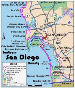
San Diego Section 9
Ocean Beach Pier to Downtown San Diego Waterfront
Trekking from Ocean Beach to the Point Loma area to San Diego's downtown waterfront offers both variety and abundant rewards in this intensely urban area. Features include one of the best sunset viewing areas on the west coast at Sunset Cliffs Natural Park, scrambles on beaches and eroded bluffs, the busy downtown waterfront with an impressive historic sailing vessel, the Star of India, and, on clear days, our first view of Mexico after 1150 miles of trail.
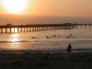
This walk starts at the Ocean Beach Pier, at 2100 feet currently the longest pier on the west coast. For a different perspective on the coast, walk out to the end of the pier and back, ¾ mile round trip. From the pier the CCT then winds its way through residential neighborhoods before returning to the coast along Sunset Cliffs Blvd. The low tide route from the pier bypasses the streets for almost a mile of rocky shoreline before climbing to Sunset Cliffs Blvd. via one of several stairways. After more residential streets, the route follows the urban shoreline of San Diego Bay to the skyscrapers at the bayside heart of downtown.
To do the inland route start at the pier and follow Niagara Avenue uphill for a block, then turn right on Bacon Street for two blocks. Go left on Coronado Avenue, right on Cable Street, then left on Orchard Avenue for one block each before turning right on Sunset Cliffs Blvd., all accomplished in six short blocks. Walk south along the sidewalk of Sunset Cliffs Blvd.
To do the low-tide beach walk, take the concrete path that starts under the pier south for 300 feet, then descend the stairs to the shore and turn left. Some of this route consists of concrete walkway set into seawalls, part is on tidal rock and some on flat tidal rocks embedded with fossil shells. Follow the shore out around a point and along the rocky coast, coming to the first stairway leading to Santa Cruz Street. Round a small cove at ⅜ mile before heading out to a narrow point, then passing Alligator Rock. Walk down the rocky shore below 40-foot cliffs to the Orchard Street stairs at ⅝ mile. If you continue down Pescadero Beach to the third stairway at Bermuda Street beyond ¾ mile, the cliffs shrink to about 20 feet. Exit the beach, walk up to Sunset Cliffs Blvd. and turn right at ⅞ mile.
The CCT follows Sunset Cliffs Boulevard south along the shoreline. Between Adair and Ladera Streets, the trail is within Sunset Cliffs Natural Park, a city of San Diego public park. Because of cliff retreat, sometimes the trail diverts to the boulevard.
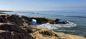
This is an area of awe-inspiring ocean views. As you proceed south from Adair Street, notice the sea stacks and characteristic geological formations, with shapes sculpted by wind and waves. With all your senses, you can experience this place where cliffs meet the sea. You notice the pounding waves, cascading sea spray, a brisk ocean breeze, and the colors of the cliffs, sea, and sky.
Walking south from Adair toward Osprey Street, you pass Osprey Point. At Pappy’s Point you see the The Arch. The Arch is a picturesque sea cave with an open ceiling, carved by waves, wind, and erosion. A little farther south, you see distinctive Cormorant Rock (or Bird Rock on some maps). Watch for pelicans and cormorants. You may see pelicans flying in formation and diving for fish.
Walking south, you pass above No Surf Beach, a pocket beach at the foot of steep cliffs. Because of precarious trails, there is limited access to this hidden gem. At broad Luscomb’s Point just beyond Hill Street, you can make the short loop around the Point. There are panoramic vistas to the north, west, and south at this premier sunset viewing area.
More cliff and ocean vistas appear as you continue south to Ladera Street. At Ladera, stairs descend to a cove with extensive wave-cut reefs. If you choose to explore the tidepools, please use caution and remember that rising tides can quickly cover previously dry areas.
At the corner of Sunset Cliffs Boulevard and Ladera Street, you have two options, A. and B. Both options take you through the Hillside Section of the Park and then through the Point Loma Nazarene University campus.
Option A:
The shorter of the two options is appropriate for both hikers and cyclists. For this option, proceed uphill, east on Ladera Street, past the first sign for Sunset Cliffs Natural Park. At Cornish Drive you see a second sign for Sunset Cliffs Natural Park and an information kiosk. Turn right (south) on the wide Shared Path. Signs permit cyclists as well as pedestrians here.
In about 1300 feet there is a Y-intersection. Take the left fork, a connecting section which includes stairs to Lomaland Drive. Turn left (north) on Lomaland Drive, continuing through campus and past the Welcome Center to the T-intersection at Catalina Boulevard.
To proceed on the CCT, cross the intersection of Lomaland Drive and Catalina Boulevard, turn left, and then make a right on Wilcox Street. After one block, turn right on Silvergate Avenue and then left on Dupont Street. (Instructions for next steps after Option B.)
Option B:
The second and longer option from the Sunset Cliffs Boulevard and Ladera Street intersection is for hikers only and adds about a mile to your walk. For this route, follow the trail that heads southeast from the first Sunset Cliffs Natural Park sign on Ladera. (Please note that this is not the trail closest to the cliff edge, where the ground can be unstable). Benches at some of the viewpoints and interpretive signs are along the way.
Follow this trail south, as it passes the parking lot to your left and east past the Native Habitat Garden,an area planted and maintained by volunteers. Along the trail you will see native maritime succulent scrub and coastal sage scrub vegetation. Watch and listen for birds, including sparrows, hawks, thrashers, towhees and the threatened California Gnatcatcher. To the south, notice the contours in the picturesque Badlands area. Where the trail connects to the wider Shared Path continue south a short distance. At the Y-intersection, there is a scenic side excursion to the southernmost section of the park.
Proceed slightly downhill, right, across a wooden pedestrian bridge and around a wide loop, the site of a former ball field. To the north, there is a panoramic view of the coastline. Notice the geological strata in the cliffs, with layers of the lighter sandstone above and the slanted darker shales and silts below.
After following the loop south and east, the side trail turns right (south), with steps that go uphill, continuing south. The trail then turns right (west), just north of a fence that is the boundary with Navy Base Point Loma. This section of trail ends at a scenic ocean overlook.
From here, you return to the Y-intersection by the same route, walking east and then north. Just after crossing the pedestrian bridge again, you are back to the Shared Path A hard right brings you back to the Y-intersection.
As in the other option, you take the left fork here, exiting the Park to Lomaland Drive. Turn left, as described above, continuing through campus to Catalina Boulevard, Wilcox Street, Silvergate Avenue and Dupont Street.
End of Options
From Dupont Street, turn left on Gage Street and right on Jennings Street. Go left on Bangor Place and then immediately turn right on Lucinda Street. where you have the first view of Mexico twenty miles south, with Downtown San Diego and the harbor not far to the east.
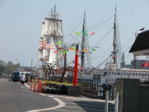
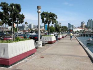
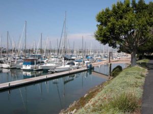
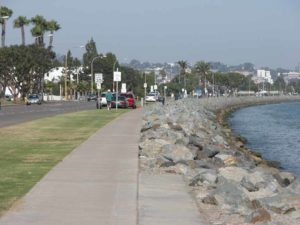
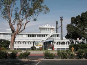
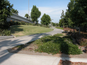
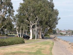
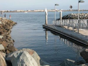
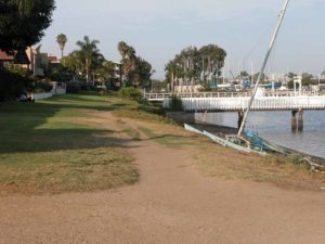
At the bottom of Lucinda Street, jog right on Harbor View Place briefly, then make a hard left down Armada Terrace to go right on Bessemer Street. At its end turn left along the shoreline path and come out on Anchorage Lane at 4⅞ miles. Walk Anchorage to its end, turn left on Shelter Island Drive for a block, then go right along Scott Street briefly. You then turn right on Dickens Street into the sports fishing marina. Walk along the dockside businesses, then make your way across a parking lot to Harbor Drive. Turn right and walk the sidewalk past the Navy's anti-sub warfare school and over a bridge. Beyond the bridge turn right into Spanish Landing Park at 6⅜ miles. Walk the shoreline pathway to the main entrance road to the San Diego International Airport across Harbor Drive. Pick up the bike path here and follow it east along the harbor. After the bike path and Harbor Drive turn south along the Embarcadero, you pass several historic ships including the impressive three-masted Star of India built in the 1870s. The section ends at 10⅛ miles at the Broadway Pier where you'll find the ferry to Coronado for the next section's adventure.
SUGGESTED ROUND TRIPS AND LOOPS: Drive or walk out to Cabrillo National Monument to visit an historic lighthouse, take in the visitor center and learn about the voyage of Juan Cabrillo in 1542 as he explored the California coast, or walk a trail through healthy stands of coastal sage scrub. The walk from the CCT route to the monument and back is about 6 miles round trip from the corner of Garden Lane and Catalina Blvd. Recent proposals call for a loop trail on Point Loma but for the present you must walk or drive the road out and back. The views are stunning from the high ridge of the point where much of the military reservation preserves the natural environment.
At the end of Bessemer Street, turn right (instead of left as on the route) on the shoreline path. It skirts the bay shore for 1½ miles before ending at a military fence. At one time the path connected to a street, now blocked by a private security fence.
Distance: 10⅛ miles (16.3 kilometers).
Open to: Hikers. Bicyclists on bike paths and streets.
Surface: Beach, trail, sidewalk.
Access point: Ocean Beach Pier.
How to get there: Exit Interstate 5 onto Interstate 8 heading west toward Ocean Beach. Take Sunset Cliffs Blvd. to Niagara Avenue, turn right and drive to the pier at the end of the street.
Other access: Anywhere along route especially Ocean Beach City Beach, Sunset Cliffs Natural Park, Spanish Landing Park, Embarcadero.
Difficulty: Moderate
Elevation gain/loss: 420 feet+/420 feet-.
Cautions: Watch for traffic on busy city streets. Use caution if you walk the tidal zone: watch for slippery rocks, sneaker waves and rising tides.
Further information: For Ocean Beach and Ocean Beach Park, call the San Diego Coastline Parks Division (619)221-8900, Maritime Museum (Star of India) (619)234-9153.
Facilities: Ocean Beach Pier has restrooms, water and parking. Urban amenities abound at both ends. Restrooms, water, picnic tables and parking at Spanish Landing Park.
Campgrounds:
Lodging: You'll find many choices of accommodations in the area. Two budget choices close to the access point are Ocean Villa Motel and Ocean Beach Motel. San Diego has two hostels, Point Loma (619)223-4778 and Downtown (619)525-1531.


Points of Interest

In the News
Interested in contributing to this project?
Register to add new photos and information, update existing results and share your trip reports.