
July 30: Monterey County
Marina State Beach to Asilomar. 16.5 miles
Ken Gray, Resource Planner with the State Department of Parks and Recreation, led the first half of our walk. Ken has been in charge of dune restoration at Marina State Beach and is currently on the City Council for the City of Marina. We began by walking a boardwalk through the restored dunes; Ken pointed out the Menzies’ Wallflower, a federally determined endangered species being planted by State Parks in the dunes.
The boardwalk soon ended and we hit the beach. This part of the Monterey Bay coast receives the full brunt of the sea’s wave action. As a result, the sand grains are very coarse, the finer ones having been washed away, making for very difficult walking. Like Sanderlings, the Coastwalkers range vertically up and down the beach, not in search of food, but in attempting to find that part which has the firmest sand. It was a futile effort; it is soft everywhere. For me the best strategy was to change my gait, walking stiff footed and raising and lowering my feet as vertically as possible. The least depression left behind meant that more energy was used in forward motion, not sand displacement. As we neared the end of the State Beach property and came upon Fort Ord, Christine Watson and Walt Allen from the Transportation Agency for Monterey joined us. Fort Ord, in the process of being turned over to civilian use, has many problems associated with the transition. It is a superfund area with 43 identified toxic sites. Ahead of us, perched on the bluff top is Stillwell Hall, formerly the enlisted men’s club for the fort. In order to delay its fall into the sea below the shore was armored; as a result it is impassable and we left the beach to detour inland around the hall.
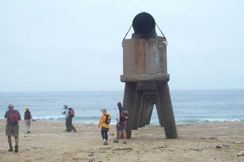
That accomplished and back on the beach, we passed three gigantic storm drain pipes on stilts; all ruined by time and the forces of the sea eroding the shoreline. It would make a great setting for the filming of a futuristic “end-of-the-world” movie.
A few miles later, we reached the outskirts of Monterey and were greeted by the media; with luck, the expedition and the cause for coastal access and the trail will be on the evening news and in tomorrows newspaper. During the interviews, we had lunch, then move out on a new multi-use trail south to the Monterey waterfront. Once there we split up, each wanting to see something different, with a promise to meet up at the Aquarium. Coffees drunk and ice creams eaten, we pressed on, following the trail along the shore to Pacific Grove and on to our hiking destination, the beautiful Asilomar Conference Grounds. Then it is a short van ride to Veteran’s Park in Monterey, our tenting spot for the night. Veteran’s Park is situated on the hill above Monterey and is a nice little park that has had a long association with Coastwalk. For the Expedition, our camping spot was comped for which we are very grateful. John Wilkes, ranger, stopped by for a chat and reminded us that since the park does not take reservations there are usually campsites available, especially in the middle of the week. For folks visiting the Monterey area it’s a wonderfully central spot to stay. At the end of today’s hike Mel and Diana left us briefly to return to Orange County and the wedding of their son. (Jon Breyfogle; photos by Linda Hanes)
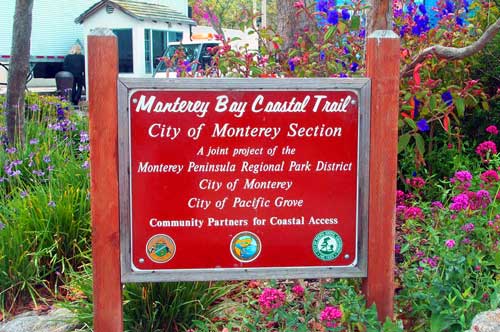
Left: naturally eroding shoreline at Fort Ord leaves derelict structure. Right: Coastal Trail sign.
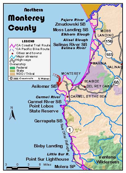
For trail section - Monterey Section 3, Monterey Section 4, Monterey Section 5