
Usage Notes

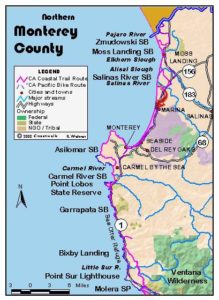
Legend: For details on the icons and trail colors, please click the legend icon on the map above.

Layers: Other layers are available. See the California Coastal Commission and Coastal Conservancy Completed Sections layer for the official completed trail segments. (About progress on the trail completion project.)
Monterey Section 3
Marina State Beach to Monterey Bay Aquarium
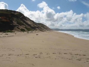
The shoreline of Monterey Bay sweeps magnificently along the sandy shore of Marina, Sand City, Seaside, and the great Monterey dunes system, then hooks westward to the rocky points of the Monterey Peninsula. This walk offers a great place to stretch out the legs on some very soft sand and observe the Monterey Peninsula as you approach it. The last 1½ miles follows the paved and popular Monterey Peninsula Recreation Trail along Monterey's waterfront full of California history and tourist attractions. We end the first volume of Hiking the California Coastal Trail at the splendid Monterey Bay Aquarium where you can experience all the different habitats hiding beneath the ocean's surface as well as some of the onshore habitats you've walked past.
To reach the Coastal Trail from the access point at the main Marina State Beach parking area, walk the boardwalk ⅜ mile to the beach. If the winds are favorable you might be entertained by hang gliders taking off from the deck built for their launching. The Coastal Trail heads north and south along the tideline. As you head south, the beach quickly becomes more quiet and remote as beach strollers turn back and high dunes isolate the area.
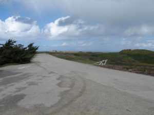
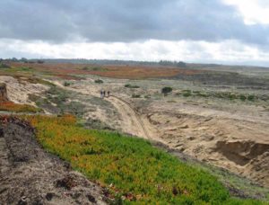
Beyond 1⅛ miles you pass the boundary of the former Fort Ord Military Reservation, now providing miles of open space plus places for a new state college and state park. Continue down the beach. At 2½ miles a large wall of riprap drops off the dunes into the surf. It protects the closed enlisted men's club, Stilwell Hall. Unless the tide is very low, you must carefully climb over the rocks, walk in front of the hall, then find and take the unmarked trail leading south and gently downhill through iceplant to a road. Walk the road to return to the beach around 2⅞ miles.
Continue along the beach through an area once used for war games. Ahead the Monterey Peninsula grows large as you draw near. You finally leave the former fort and reach the badly degraded dunes of Sand City around 5⅜ miles. This whole area has been mined for its fine beach sand.
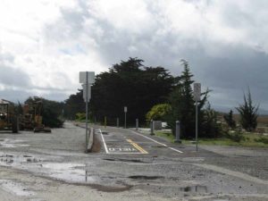
At 6¾ miles you'll see the tall Monterey Beach Hotel sitting on the dunes to your left. California State Parks has restored the adjacent dunes of Monterey State Beach to illustrate how beautiful the dunes will look after more extensive restoration plans are completed. You can walk on a boardwalk to observe the area. As you continue south, freshwater Roberts Lake sits about ¼ mile inland. A side trail leads from the beach to the lake. Adjacent to the lake at Roberts Avenue, the Monterey Peninsula Recreation Trail reaches its northern terminus. One could follow that paved path all the way to the Monterey Bay Aquarium at this section's end, but for now the Coastal Trail continues along the beach.
As CCT continues down the coast, the beach remains wild but the buildings and bustle of the Monterey area become more prominent. The beach angles southwest then west, aiming for the Monterey Peninsula. As you pass more access ways, you'll find more people enjoying the beach. Finally you walk the narrow strand along the Window on the Bay portion of Monterey State Beach. As the sand ends at 8¾ miles, you come to the Municipal Wharf #2. At the wharf you'll find a popular cafe if you need a lunch break.
After you leave the Municipal Wharf, Monterey State Historic Park nearby on your left features buildings surviving from Monterey's early days. You pass Fisherman's Wharf before 9¼ miles, the Coast Guard Pier around 9⅜ miles, then continue on the busy paved trail for nearly a mile, the last half of it through Cannery Row made famous by John Steinbeck. The sardine canneries closed long ago, but their remnant buildings today house restaurants, bars and abundant gift shops of every kind. The paved trail follows the old railroad right-of-way overlooking the waterfront, paralleling the street called Cannery Row downhill on the right.
When you reach David Avenue just before the Monterey-Pacific Grove city line at 10¼ miles, the northern half of the California Coastal Trail has nearly reached its end. Turn right and follow the sidewalk of David Avenue a half block downhill to end your hike at the wonderful Monterey Bay Aquarium at the northwest end of Cannery Row.
The aquarium, which so eloquently displays the California coast's natural abundance, marks the official midpoint of the nation's most fascinating and diverse trail, the California Coastal Trail. CCT has traversed 600 miles from the Oregon border, and it continues 597 miles more along the coast to the California-Mexico border.
The Monterey Peninsula Recreation Trail continues into the town of Pacific Grove, following the waterfront about another mile to Lovers Point.
From there a waterfront path continues most of the way around the peninsula.
SUGGESTED ROUND TRIPS & LOOPS: From Marina State Beach south to Stilwell Hall and back makes a pleasant 5¼-mile round trip on a seldom walked beach. From around the Municipal Wharf in Monterey, walk north for miles on the beach and return, or follow the Monterey Peninsula Recreation Trail to explore the many attractions of the Monterey waterfront. Another nice town walk, the Path of History, branches off the Recreation Trail at Monterey State Historic Park.
Distance: 10¼ miles (16.5 kilometers).
Open to: Hikers. Bicyclists on the Monterey Peninsula Recreation Trail.
Surface: Beach, paved trail.
Access point: Marina State Beach.
How to get there: Take Reservation Road exit from Highway at the north end of the city of Marina. Drive west to the parking area at the end of Reservation Road.
Other access: Monterey Beach Hotel has public parking and beach access adjacent to it. Anywhere along the Monterey Peninsula Recreation Trail. The waterfront district of Monterey has abundant parking.
Difficulty: Moderate
Elevation gain/loss: Negligible.
Cautions: Some of the beach may be impassable at high tide.
Further information: Monterey State Beaches, Monterey State Historic Park (831)649-2836, Monterey Bay Aquarium (831)648-4888.
Facilities: Marina State Beach has restrooms, water. Monterey has all services.
Campgrounds: Veterans Memorial County Park is in Monterey. Laguna Seca Recreation Area 7 miles east has 183 sites.
Lodging: Abundant in Monterey area.
Points of Interest

In the News

Interested in contributing to this project?
Register to add new photos and information, update existing results and share your trip reports.