
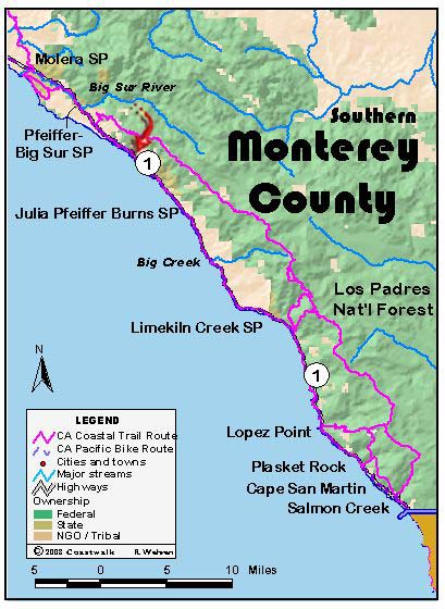
August 4, Monterey County Andrew Molera State Park to Partington Cove. 14.5 miles This was a special day for the walkers. During the course of the day’s hike, we passed the site of the marriages of two of our walkers: Ginny and “J”. Their love of the coast runs long and deep.
The day began cool and crisp; the 6 AM starting time for coffee and breakfast is now in the half-light of early dawn. The days are getting shorter. Several of us independently mused that fall is in the air.
Yesterday and today we hiked through areas that are hard hit by Sudden Oak Death. As we looked out at the hillsides around us, we saw large areas of gray branches, victims from last year or preceding years, and orange areas: this year’s fatalities. In some areas it is worse than any instances we have yet seen, even in Marin County, the epicenter of this disease. State Parks’ personnel have told us that a great amount of their work now is felling and cutting up diseased oaks within the campground areas.
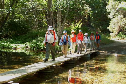
From Molera, the highway cuts inland following the Big Sur River. Our path was the highway, but we are able to take off on a parallel trail for a bit. This trail runs between the river and the highway. A surfer told us of another trail and at the private Fernwood Campground, we were able to cross the river on their bridge, find the trail, and continue along for ½ to ¾ mile. This trail begins with a small circular maze, which spirals into its middle and then out again. For luck, we all followed its windings in and out. We were able to cross back, over to the highway at a ford and little wooden footbridge, opposite the entrance to Pfeiffer Big Sur Park.
Highway Thoughts: Few drivers can conceive of how fast they drive, relative to a walker on the side of the road. People traveling in automobiles are terrible sources of distance information. Distances for them are defined by time, not distance. Distances for walkers are defined by distance. Drivers are oblivious to elevation change; walkers sense every little change in grade. Nothing is so comforting to a walker as hearing the car behind him go over the little “Bot’s Dots”, those little raised reflectors at the centerline. This means that they are pulling over to make plenty of room.
Our lunch spot was at the Nepenthe Restaurant: more particularly the Kevah Café. It was here on the patio overlooking the sea that Ginny tied the knot. Those of us who balked at the $3.00 charge for a small coffee, found a place nearby to eat our sandwiches.
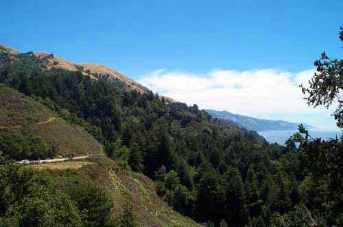
After lunch we continued along a much more vertical coastline. The highway is cut from almost sheer cliffs, affording us magnificent views up and down the coast. It was a beautiful day for vistas; we saw as far as the landforms and the curvature of the earth let us. Along the way we stopped at the Henry Miller Museum and Bookstore and soon after, at the Coast Gallery. We entered wearing our orange highway vests. At the small café, I inquired as to the cost of a coffee. “Free to CalTrans workers” was the reply. “But I’m not a CalTrans worker – what’s the cost for someone walking from Oregon to Mexico?” is my reply. “That works!” says the clerk, so its free coffee for the CTE 03.
Our last few miles to Partington Cove were lightened by groups of whales, perhaps ½-mile offshore. As we walked, we watched them spout and dive. They appeared to be moving in no particular direction, milling about in pairs. (Jon Breyfogle; photos by Linda Hanes) Left: Crossing the Big Sur River. Right: View from the Nepenthe restaurant