
August 26, Santa Barbara County Goleta Pier to East Beach. 10 miles
Note from yesterday: sometime in the late afternoon as we reached the University of California campus, we began our 900th mile of this journey.
Today was to be a lazy day with plenty of leisurely beach walking. However, it didnt start out that way. Within 100 yards of our start, we encountered our first obstacle for the day the Goleta Slough. It was one of those times that would make you proud to be one of this group of hikers or envious that you arent. Its 8 AM; the fog is thick and the first thing you do on a long hike is get wet up to your waist in chilly water, crotch high if youre tall. The bottom was sandy so the footing was good, but you had to thread your way along a narrow corridor, avoiding the deeper backwater on your left but trying to avoid the incoming waves on your right. Sometimes you didnt thread the ideal path correctly, and the water got a foot deeper quickly. Fortunately, we are all seasoned waders by this point, so we laughed as we continued down the beach in our wet clothes.
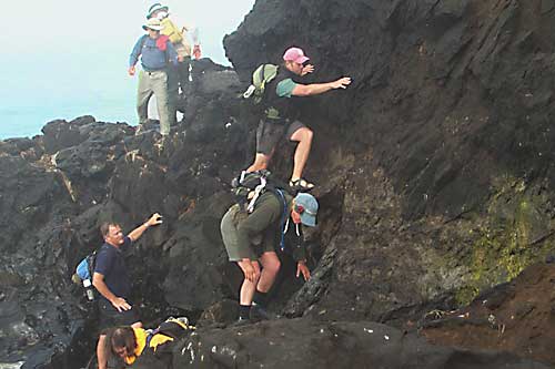
Gaining the beach on the other side, we continued along but soon ran into our next challenge: tar. Because we were only an hour or so from the high tide, we were forced to go up and over a point consisting of solidified tar, natural tar that had oozed out of the bluff. The trick was to not get too high where this outpouring of tar met the overlying soil. Here the lighter soil mixed with the dark petroleum product to form a brown staining soil. If youve ever seen any leaked motor oil that gathered dust, you can visualize why it was important we didnt touch, or sit on or fall on it. Later we came upon more benign tar outpourings: tar that took on wonderfully sensual shapes comparable to the exuberance of form in the curves of a 39 Ford pickups fenders. Then, after the tar, we came to a spot where the waves came up against a stepped concrete seawall. Some of us made it past on the wall itself, others made it through in the water. We found out here that our Coastwalk digital camera is indeed waterproof as its bearer, Linda, stumbled on a hidden rock and sat down in the water.
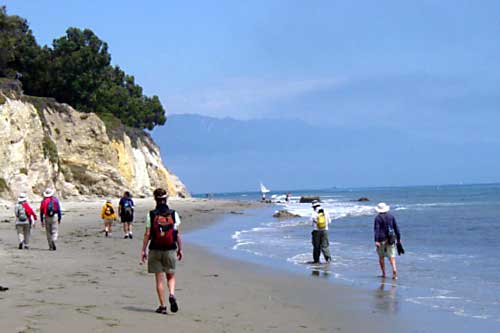
The first few hours were spent in these adventures; the rest of the day was a relaxed stroll along broad sandy beaches or along multiuse paths under a light fog, with the blue sky playfully staying just inland.
Soon we crossed More Beach where, judging from the attire of the only sunbather, more means less. Lunch time found us at Arroyo Burro where we spent some time touring the new South Coast Watershed Resource Center where SB school 4th graders and junior high school students get hands-on experiences in watershed issues. (Note from Linda–a retired librarian: I think this place has been very well set up, and is a good model for other places to follow.)
By this time we were near downtown Santa Barbara, yet the beaches were relatively deserted. High on the bluffs above were houses, some about ready to join us on the beach below. Our introduction to the city was from a bluff-top trail: we looked east across the waterfront to the downtown area with its backdrop, the surrounding hills, today topped with high cumulus clouds at their peaks and shrouded by fog on their lower slopes.
We joined the downtown scene by walking the multiuse path past the wharf and on to East Beach. Beyond the wharf, Rob Almy, our guide, pointed out where the sand is dredged from the broad beach and spit, east of the wharf, and taken by barge up to Gaviota beach where it is pumped onshore to make its way back. We also saw two blue oil-cleanup ships anchored out in the bay. (Jon Breyfogle; photos by Linda Hanes)
Left: Scrambling over tar seeps. Right: Beach and bluffs east of Goleta. Santa Ynez Mtns. in the distance.
For trail section - Santa Barbara Section 8, Santa Barbara Section 9