
Usage Notes

Legend: For details on the icons and trail colors, please click the legend icon on the map above.

Layers: Other layers are available. See the California Coastal Commission and Coastal Conservancy Completed Sections layer for the official completed trail segments. (About progress on the trail completion project.)
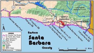
Santa Barbara Section 8
Goleta Beach County Park to Arroyo Burro Beach County Park
You wouldn't expect to find a wild, lightly used beach amidst such a large urban area as Santa Barbara, but most of this section is lightly visited except on the warmest days. The west end gets very light use beyond the ford of Goleta Slough. Although numerous houses lie up from the beach around the big tar seep, the beach offers more seclusion than crowding. In this section's middle you'll find More Mesa Beach, a popular clothing-optional strand, the use of which is lessened by the ½ mile walk required to reach it. East of there, the residents of the exclusive Hope Ranch subdivision on the bluffs above use the beach lightly for walking, sunning and horseback riding. Only on the section's east end will you find more beach users. They make the easy walk west from Arroyo Burro Park to enjoy the shore. Much of the charm and remote feeling you'll find here result from the high cliffs shielding the shoreline from the busy residential areas above it.
From the east end of the parking lot, walk the sand spit along its slough side until you near its end, about ⅛ mile. Find a safe place to ford the slough near the mouth of Atascadero Creek, planning your ford to reach the opposite shore to the right of the cliff and be able to walk east. The ford is about fifty feet across, knee to waist deep depending on the tide.
Once across, walk east on a gorgeous, usually empty beach. Pass eucalyptus trees atop the low bluff on your left by ⅜ mile. The light-colored cliffs get higher as you walk east, with their highest point near the radio towers around ½ mile. Before ⅞ mile you see houses atop the bluff as the beach narrows, ending at a house-sized tar seep. At very low tide you can walk the water line around the tar seep. At tides of +3.0 feet or less you can climb over the mostly hardened tar along the top of the seep, but watch for wet, oozing spots. If the tide is higher, you might want to take the inconspicuous stairway just before the elephantine seep that links to a rough path across the sloughing bluff above the seep.
Whichever way you pass it, you're beyond the tar seep by one mile. Walk the broad beach east, passing smaller tar seeps along the top of the blond beach. Pass a few more houses visible atop the 60-foot bluffs, but by the high gray-cliffed point beyond 1⅛ miles no more homes are visible. You can see the high cliffs down coast that give this city walk its remote feeling. Except at the highest tides it's usually easy to walk around the two more large tar seeps at the base of the cliffs around 1¼ miles.
Walk a broad beach east. It narrows at a high rocky point at 1½ miles that's passable at all tides, then broadens as you continue east. No boundary marks the start of More Mesa Beach, favorite clothing-optional sunning and bathing spot for the locals, but by 1¾ miles you're definitely on More Mesa Beach. Its access path descends from the high bluff around 2 miles. It offers an escape route that leads to Mockingbird Lane in west Santa Barbara if you walk the ½ mile path north.
CCT follows the beach east as the high bluffs on your left reach a marvelous 120 feet high. Continue along the shore beneath the Hope Ranch, a gated community with no other public access. Watch for equestrians on the beach. At 2½ miles you pass a canyon where Hope Ranch's Las Olas Drive descends to the beach. Beyond the canyon as the high bluffs rise again, you walk the shoreline of Hope Ranch Park, with lands above the high tideline open only to Hope Ranch residents and guests. Beyond the park, you'll probably once again have the beach almost all to yourself.
The beach narrows on the way to a small point. After you round the point at 3 miles, the beach broadens again. Soon the bluffs on your left have a slightly less vertical slope and support more vegetation, but they soon become even higher, towering 140 feet. CCT continues east on the beach, passing another small point at 3¾ miles. Pass an indentation or cove on the bluff around 4 miles and quickly enter Santa Barbara city limits where a few houses perch part way up the bluff. After the cove along the bluff ends, pass the highest bluff of all, towering 169 feet overhead. Walk a narrow beach beyond it where you might not get through and stay dry at high tide.
Assuming you can pass the narrow spot, walk the beach as it angles due east below descending bluffs. By 4¾ miles the bluffs end at the mouth of Arroyo Burro. Walk 200 feet to section's end where the parking lot for Arroyo Burro County Park lies just north of the beach. The next section continues along the bluff-sheltered beach beyond the mouth of Arroyo Burro's creek.
ALTERNATE ROUTE: At high tide the first two miles of beach may be impassable or difficult to pass at several points. If so you can follow the Atascadero Creek Bike Path east from the park entrance, then descend to the beach via More Mesa Trail.
SUGGESTED ROUND TRIPS & LOOPS: Walk the beach from either end for as long as you like. like. Make a loop at the west end by looping back on More Mesa Trail and Atascadero Bike Path.
Distance: 4¾ miles (7.6 kilometers).
Open to: Hikers, dogs.
Surface: Beach.
Access point: Goleta Beach County Park.
How to get there: Exit Highway 101 west of Santa Barbara onto Highway 217, Ward Memorial Blvd. Go 2 miles, take the Airport/Sandspit Rd. exit. Go left for Sandspit Rd., follow it to the park, go right to enter, then left to parking lot at end of road.
Other access: More Mesa Beach, a clothing optional portion of the larger beach. Exit Highway 101 at Turnpike Road, go south to Hollister Avenue and turn left. Take the second right onto Puente Drive which leads to Vieja Drive from which you turn left on Mockingbird Lane and park at its end. Walk the ½-mile trail to the beach.
Difficulty: Easy
Elevation gain/loss: 30 feet+/30 feet-.
Cautions: Day use open 8 a.m. to sunset. No overnight parking in day-use lot.
Further information: Goleta Beach County Park (805)967-1300, Arroyo Burro Beach County Park (805)687-3714.
Facilities: Restrooms, water, phone, picnic areas, snack stand and cafe at both ends.
Campgrounds: El Capitan State Park 12 miles west has 142 units on the state park reservation system plus several hike/bike sites. Another choice is El Capitan Canyon, a private campground north of the highway at the same exit.
Lodging: Many choices in Santa Barbara and Goleta. Banana Bungalow, Santa Barbara (805)963-0154.
Points of Interest

In the News
Interested in contributing to this project?
Register to add new photos and information, update existing results and share your trip reports.