
August 7: Monetery County Gorda to Salmon Creek via the Cruikshank and Buckeye Trails. 12 miles
This is being written on the afternoon of August 8, which is good because it has given time for reflection.
The last three days have all been more than 14 miles, and we are tired. On paper August 7 is just 12 miles, but there are some caveats to this distance.
We began the day by meeting Ranger Gary Nelson in Gorda. For the first 4 miles we were on the highway. Then at the start of the Cruikshank Trail, we met up with Gary’s helpers, Mac Wilson – young and exuberant, helpful and excited about his October 4 marriage back in Memphis – and Forrest–older, courteous, knowledgeable and enigmatic. Big Sur is a region rife with pseudonyms. Besides Forrest we’ve bumped up against Tiger Windwalker and Twister; others have crossed our path but their names weren’t recorded.
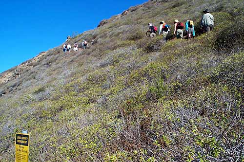
The trail began precipitously with several hundred feet of switchbacks, and continued precipitously. The day was hot and getting hotter. The country side was steep. I cannot give a percent of slope but most of the country seems as close to a cliff as you can get and still have vegetation growing on it. And it seemed that the predominant shrub along the way was poison oak. For most of the way to our first major break at Upper Cruikshank Camp, the trail was on a north facing slope so there were trees, sometimes redwoods, and shade. Also to this point, the trail was well defined if not a little brushy. We started out near sea level. Upper Cruikshank Camp is at 1,350 feet elevation. Then the fun began. Between Upper Cruikshank and Buckeye Camp, there basically was no trail. To be charitable, one could call it a track. At least it appeared that at some prior time someone walked it.
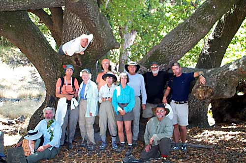
We crested the ridge at 2,260 feet and had tremendous views of the coast. To the north we gazed back over the last few days of walking; to the south we could see weeks of our future. On the far southerly horizon, we could see to Montana De Oro. Led by Gary we contoured downward into a drainage where small puddles of clear water afforded us a place to dip our hats and use them as buckets to pour the coolness over our heads. Then it was a short climb up to Buckeye Camp and, of all things, a picnic table in the wilderness situated under a large bay tree. Beside the tree was a built-up spring with water pouring out of a pipe.Throwing caution to the wind several of us tank up on this unproven water source.
From Buckeye Camp it was more steep-and-slippery up-and-downs as we went over several ridges and through several drainages until we entered the Salmon Creek watershed and our destination where Salmon Creek hits Highway One. Here most of us took our poison-oak-oil saturated bodies, striped to what seemed appropriate and swam in the cool waters of the beautiful pool under Salmon Creek Falls.
Back at camp we made our dinner of various leftovers, including fresh produce and other goodies left by Bill Albright and Michelle Pattee, folks you might remember from our stay at The Sea Ranch so long ago.
We have gotten into the habit of reading out loud a chapter from J. Smeaton Chase’s “California Coastal Trails”. This night the reading occurred right after dinner, and then we all crawled wearily into our beds.
An afterthought: As we walk along the crowded and dangerous Highway 1, we constantly are hoping for a means to get off it. But what is needed is some parallel path, not the huge loops that are now available with their built in strenuous elevation changes. These loops utilize trails whose original purpose was to get away from the coast and into the hinterlands. They were tracks leading to settler’s cabins or stock areas. A world-class California Coastal Trail will not be achieved by the stringing together of such loops. (Jon Breyfogle; photos by Linda Hanes) Left: Cruikshank Trail switchback and survey project marker; Right: Hikers under huge buckeye tree.
For trail section - Monterey Section 14, Monterey Section 15