
Usage Notes

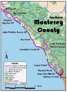
Legend: For details on the icons and trail colors, please click the legend icon on the map above.

Layers: Other layers are available. See the California Coastal Commission and Coastal Conservancy Completed Sections layer for the official completed trail segments. (About progress on the trail completion project.)
Monterey Section 14
Pacific Valley to Cruikshank Trailhead
West of Highway 1 between Pacific Valley and Jade Cove, a broad coastal marine terrace slopes gently to the shore, providing room for unique leg of the CCT through Big Sur. The only other place in Big Sur with such gentle terrain along the shore is north of the mouth of the Big Sur River where the terrace is private property. Happily the Pacific Valley terrace is U. S. Forest Service land, and the CCT leaves the highway here to ramble along the ocean bluffs, leaving the roar of highway traffic for the rumble of surf. The convoluted shoreline, dotted with the ancient shell middens of long-gone native seafood harvesters, faces a jumble a of offshore rocks that punctuate the coast's beauty. On clear days you'll find long views up and down the rugged coast. When winds are right, you may see hang gliders landing on the terrace. Between two jutting promontories north of Plaskett Creek, the terrace narrows above the graceful sweep of Sand Dollar Beach, a sandy crescent perhaps worth a side trip. Beyond the crossing of Plaskett Creek, the terrace broadens again until CCT crosses the access trail to Jade Cove, which descends to rocky coves popular with rock hunters, worth a detour at a low tide. Soon after that, CCT must return to the highway for another substantial road walk relieved only by the colorful southern Big Sur commercial center called Gorda, the only place with gas, food and lodging for miles.
Climb over the hiker's ladder and walk west 75 feet to where the trail splits into three, with the CCT on the left. The middle path dead-ends on the bluff in 250 feet. The track on the right heads north, then west to drop to a gravel beach north of the rocky point in ¼ mile.
Take the left fork on a gentle descent south paralleling the highway. Before ⅛ mile you contour above the head of two gullies, pass the "PACIFIC VALLEY" sign on the highway, then dip through a third gully. Continue past another hiker ladder to a fork.
Take the right fork to descend southwest to a fork near the bluff's edge at ¼ mile. Veer left on a path that fades as it nears the point in 250 feet, then follow the bluff edge south. Pick up a vague track that contours above the rocky tideline. Follow it past the head of a gully above a small beach at ⅜ mile, then on to merge with a more distinct path from a third hiker ladder in 300 feet.
Contour south with offshore and onshore rocks ahead, passing east of a rock outcrop before ½ mile. Dip through a gully and return to the marine terrace to pass east of another sandstone outcrop. An easy scramble to the top provides a good view of the trail and the broken rocky coast to the south.
Contour south-southeast across the headlands, returning to the bluff edge at ⅝ mile. Continue along the convoluted bluff edge, sometimes trackless. Before ¾ mile you meet a vague track descending from another hiker ladder on the highway. Pass east of a broad rock outcrop (watch for poison oak!) and head south across the headlands.
You soon want to veer right on the path out to a grassy point, coming to a yellow section marker at ⅞ mile. Follow the trail as it continues along the bluff edge, dipping through several tiny gullies. You reach another bench marker at one mile. Then CCT angles southwest to a rocky point at 1⅛ miles where you overlook a small sandy crescent beach.
Follow the bluff edge above the strand, meandering east around a gully, then back west, coming to a fence at 1¼ miles. Cross it on a hiker ladder 50 feet toward the highway, then head southwest to the lip of Prewitt Creek's canyon. Find the path winding down to the creek at 1⅜ miles. It's usually an easy ford -if you can't ford it you must head east to the highway. Across the creek a path winds up the canyon's south wall to the bluff. However, you might first want to walk 100 feet downstream to the creek mouth and a spectacular, rocky low-tide beach. (When the tide is low you might walk the beach south.)
After climbing back to the blufftop, cross another hiker ladder and follow the bluff edge south, passing above arched rocks on the beach below. Cross the head of a gulch at 1⅝ miles, then follow the trail west-southwest heading for the point. As you near the point, the trail turns south to climb over the rocky point near the bluff edge. By 13 miles the broad arc of Sand Dollar Beach comes into view to the southeast. You can also see Pfeiffer Point 28 miles up the coast.
Your trail turns east following the low ridgetop. This soon leads across a seemingly misplaced dune. Continue generally southeast following the coastline toward Highway 1, passing a spur on the left that heads east to the Pacific Valley Ranger Station beyond the highway. The route turns brushy before the rock outcrop at 1⅞ miles, but pick your way to grasslands for easy walking. Pass to the left of more rock outcrops around 2¼ miles, ignoring the fork on the right. Climb gradually southeast toward another hiker ladder beside the highway at 2 5/16 miles. Just 125 feet before the ladder, veer right on the track that heads south through a gate to dip and rise through a deep gully and pass a big rock outcrop between you and the coast, its east face shrouded in bay laurel. Dip through another arroyo on this cow path-CCT, then contour across a narrow headland at 2½ miles, heading south toward tall trees.
At 2⅝ miles a hiker ladder just ahead on the left leads to the Sand Dollar Picnic Area and Beach parking lot beneath the trees. A well-graded spur trail on your right descends west to Sand Dollar Beach, the largest strand in Big Sur, ¼ mile round trip.
CCT continues south or southwest across open headlands. Choose either of the two paths that will soon rejoin. The left and shortest trail crosses a broad path (heads west to point) from the south hiker ladder by the parking lot and descends toward Plaskett Creek at 2¾ miles. When the track forks again, take the right fork to a generally easy ford of the rocky stream beneath alders 100 feet below the highway.
Return to the marine terrace at 2⅞ miles and contour south with views west to the chaparral-draped point and Plaskett Rock, the big sea stack offshore. Look north for a grand view up the coast and up the deep canyons of Prewitt and Plaskett creeks. Your trail dips through a gully, then forks. Take the middle of three paths southwest.
At 3 miles you cross a distinct trail from the hiker ladder beside the highway 200 feet east. Continue southwest across several more spurs heading for the shore. Gain vistas south to rugged Cape San Martin and the immense sea stack off that point by 3⅛ miles. Contouring south, you pass west of a rock outcrop and return to the bluff's edge. Merging with another bluff edge path, your trail suddenly turns distinct, with the surf churning 150 feet below.
Cross the Jade Cove Trail at 3¼ miles where it drops to a tideline access stairway. The rocky beach below is best at low tide. Continue along the bluff edge track to a fork before 3⅜ miles. Veer right to follow the bluff's edge, rounding a point with views across the ocean to Cape San Martin. Then your trail turns eastsoutheast on a gradual ascent toward the highway. You may need to veer due east when brush chokes the path, but by 3½ miles head southeast toward a house with a palm tree east of the highway.
CCT returns to Highway 1 at 3⅝ miles at Milepost 13.06. Walk the road's shoulder south up a gentle hill, crossing a brushy gulch and passing a large a eucalyptus grove on the right. The climb ends at a vista point. Descend around the nearby point, passing a spur on the right beyond 4¼ miles. Its overgrown tread descends west and south before dead-ending on the bluff. Continue down the highway to cross the bridge over deep, wide and rugged Willow Creek Canyon at 4⅞ miles. For a closer look at the stark landscape from sea level, turn right on a spur road beyond the bridge to descend to Willow Creek Picnic Area and a rocky beach with a view of Gorda Rock offshore.
CT continues along Highway 1, ascending over Cape San Martin and up to a junction with Willow Creek Road at 5½ miles. That steep and winding dirt road, also known as Los Burros Road, climbs east along a ridge for 6.3 miles to end at South Coast Ridge Road, elevation 3470 feet. Along the way lt meets the Willow Creek Trail on the left at 2.4 miles and the Alder Camp Road on the right at 4.7 miles, which descends 1.4 miles to the camp and the northern Buckeye Trailhead.
Climb south along the highway to a summit around 6⅜ miles, then coast down to the mini-metropolis of Gorda at 6½ miles, where a small store and a good restaurant offer the only provisions along 25 miles of southern Big Sur. Follow the highway shoulder southeast, ascending almost to 6⅞ miles, then gently down to 7⅛ miles before another brief climb to 7⅜ miles.
Descend steadily along the highway to 8¾ miles, where you're only 30 feet above the breakers with sheer slide-torn cliffs east of the road. Ascend gradually beneath more cliffs to the Villa Creek bridge at 9⅝ miles, then steeply to section's end at Milepost 6.5 at 10¼ miles, where the Cruikshank Trailhead east of the highway marks the start of Section 15.
ALTERNATE ROUTE: You could stay on the highway from Pacific Valley to Jade Cove, but you'd miss a wonderful gentle headland route. One could ascend Willow Creek Road, then drop to Alder Camp to follow the Buckeye Trail south to Upper Cruikshank Camp on Section 15, but that would add several miles, wilderness route finding, and much elevation gain and loss. Also see the Alternate Route for Section 12 for the southern Big Sur high route.
SUGGESTED ROUND TRIPS & LOOPS: Follow the described route to Sand Dollar Beach or Jade Cove, then return the way you came or across the upper marine terrace or along the highway.
Distance: 10¼ miles, with 3⅝ miles of blufftop trail (16.5 & 5.8 kilometers).
Open to: Hikers, dogs. Bicyclists on road portion.
Surface: Trail, highway shoulder.
Access point: Pacific Valley.
How to get there: Park in turnout on west side of Highway at north end of Pacific Valley at Milepost 16.0, 6 miles north of Gorda.
Other access: Several hikers ladders south along highway, Sand Dollar Beach (fee charged), Jade Cove Access and anywhere south along highway portion.
Difficulty: Easy
Elevation gain/loss: 980 feet+/790 feet-. 290 feet+/210 feet- for trail portion.
Cautions: Watch for poison oak. Watch for rogue waves near tideline. Use extreme caution when walking highway shoulder.
Further information: Los Padres National Forest, Monterey Ranger District (831)385-5434.
Facilities: Sand Dollar Picnic Area has phone, tables, fire pits and wheelchair accessible chemical toilets. Gorda has phone, cafe, store, gas and lending library.
Campgrounds: Car camping at Plaskett Creek Campground east of Highway along this section and at Kirk Creek and Limekiln Campgrounds to north.
Lodging: Extremely limited in southern Big Sur, Gorda has three cabins with views but they're not inexpensive. Lucia Lodge to the north and Ragged Point Inn to south are the only other choices.

Interested in contributing to this project?
Register to add new photos and information, update existing results and share your trip reports.