
Usage Notes

Legend: For details on the icons and trail colors, please click the legend icon on the map above.

Layers: Other layers are available. See the California Coastal Commission and Coastal Conservancy Completed Sections layer for the official completed trail segments. (About progress on the trail completion project.)
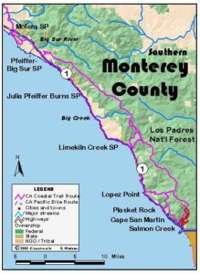
Monterey Section 15
Cruikshank & Buckeye Trails, Silver Creek Wilderness, to Salmon Creek to Ragged Point
You'll find several features that approach both heaven and hell if you walk most or all of this section. Happily the 14,500-acre Silver Peak Wilderness was established in 1992, and the section's first 7⅞ miles follow the Cruikshank and Buckeye trails to explore many highlights of this steep and rugged wilderness. Despite an elevation gain exceeding 2000 feet, most of the trail is well graded, leading to grand vistas of southern Big Sur and the coast south to Santa Barbara County. The immediate scenery is also lovely and dramatic. The real drawback of this wilderness hike consists of a one-mile segment from 3 to 4 miles where the trail is brushy and difficult to follow. We explicitly describe that part of the hike, offering a a cross-country route bypassing the worst bushwhacking between 3½ and miles. We urge you to travel with friend, carry map and compass and pay close attention there. Cruikshank and Buckeye trails are still recommended over walking the winding highway. Several of the CCT Whole Hikers of 1996 considered Buckeye Trail a highlight of their trek despite the difficulties. All camps along the trail offer pleasant sites and water, especially the big meadow at Buckeye Camp. After CCT leaves the wilderness at the abandoned Salmon Creek Ranger Station, it's once again forced onto the narrow, twisting shoulders of Highway 1. If you walk the road leg, we wish you clear weather for the astounding views as you descend into San Luis Obispo County and out of the Big Sur.
Ascend northeast on the Cruikshank Trail on excellent tread across brushy slopes. After a notice board, climb moderately by switchbacks. Beyond the eighth switchback around ½ mile, a short spur on the left leads to a rocky outcrop with a vista of the rugged coast. You soon cross a ridge and turn north on a steady ascent. After gaining a second ridgetop at ¾ mile, contour through high brush on the ridge's north face with views up Villa Creek Canyon. After passing the first small redwoods around 1⅛ miles, the high chaparral yields to a stately live oak woodland with an open understory. Descend briefly to 1¼ miles, traversing a steep gulch with four-foot-diameter redwoods, then climb gradually through mixed forest. After a gulch, a short steep climb leads to an ocean view.
The tread gets rougher as you ascend fitfully up canyon, the vegetation a jumble of hardwoods, brush and conifers including ponderosa pines. Beyond 1¾ miles, contour across a dry rocky slope with a Pacific view, then through shady mixed forest. Cross a seasonal stream on a redwood plank, then another stream to reach pleasant Lower Cruickshank Camp with a table and grill beneath redwoods before 2 miles. Ascend gradually to a junction before 2¼ miles. The north end of the Buckeye Trail forks left to descend ⅝ mile to Villa Creek, where Villa Creek Camp lies just downstream, then contours and climbs to end at Alder Creek Camp, 2¾ miles from the junction.
CCT turns right on the combined Buckeye and Cruikshank Trails, passing rustic Upper Cruikshank Camp and climbing southeast into rolling grasslands. After passing a fenced stock enclosure, you reach the upper junction.
Cruikshank Trail forks left, climbing past its namesake homestead site and on up to Lions Den Camp and South Coast Ridge Road in 4¼ miles.
The Coastal Trail forks right to climb southeast, then south on the Buckeye Trail. It contours from 2⅜ to 2½ miles, then resumes a moderate ascent on vague tread sorely in need of maintenance. (It gets much worse beyond the ridgetop!) Orange plastic flagging helps to mark the route. Ascend a ridge to 23 miles, then veer to the right up a dark gully. After leaving the gully at 2⅞ miles, ascend steeply west with grand canyon and ocean vistas.
Contour briefly from 3 miles, then ascend rough tread across steep slopes to a ridgetop. Take a minute here to absorb the fine view and orient yourself, especially if you'll return this way, since Buckeye Trail's vague tread tangles with a mix of volunteer and animal paths around the ridgetop. To the north beyond Villa Creek you can see Alder Creek Canyon and San Martin Top (3098*) beyond. Buckeye Trail turns east, dropping left of the ridgetop briefly only to switch back up to and along it on nearly invisible tread. Pass an encouraging sign facing the other direction at 3¼ miles that proclaims "TRAIL AHEAD OPEN." Although the vague track may appear to drop to the right of the ridgetop, it truly ascends along it, passing yuccas and gaining views south to Redwood Gulch. As you ascend for 1000 feet beyond the sign, watch for the spot where Buckeye Trail leaves the ridgetop, a nearly level saddle just east of a ridgetop knob (2318'). Just south of a charred oak snag there, Buckeye Trail and CCT head southeast on a gradual descent. The route is heavily choked with fragrant sage, so we recommend long pants for the next ¾ mile.
Be aware that where Buckeye Trail leaves the ridgetop, a volunteer trail conlinues up the ridge. On my first hike here I found myself 300 feet above and ¼ mile beyond the actual ridge-leaving spot before I knew I'd left Buckeye Trail. I believe the ridgetop trail actually continues east to Silver Peak (3590'). This trail in fact offers a steeper but less brush-choked and only ⅛ mile longer route. To take it, continue up the ridge to 2580-foot saddle at 3¾ miles, then descend the spur ridge south that ends at the confluence of two forks of Redwood Gulch. After only a little brush and by angling slightly west of the ridgetop, I dropped right onto the Buckeye Trail a few feet before it traverses wooded Redwood Gulch. The brushy main trail descends southeast from the ridgetop, winding through two steep gullies, then crossing a southwest-descending ridgetop. Continue descending gradually southeast to pass above a large live oak. The descent increases across a brush-choked gully and steep slopes. Around 3⅝ miles, cross another gully beneath live oaks, then contours east briefly on the roughest, brushiest gully crossing of all. The vague tread contours southeast, then south.
Look south-southeast from here to see large Buckeye Meadow at your elevation, but it's a rough ½-mile hike, especially the next ¼ mile. The view includes Redwood Gulch and much ocean. Continue south past a large live oak and Coulter pines, then east across a steep slope past more pines to cross the top of a gully. Descend southeast through heavy sage with at least two parallel tracks around 3¾ miles. Descend steeply, then contour across a large gully. Make a wind-ing descent through two more gullies, crossing the last beneath a live oak a at 3⅞ miles. Continue south-southeast across a west-facing slope past two young Coulter pines. Buckeye Trail improves as it bends left around the base of a ridge (the spur ridge where cross-country route rejoins trail), then descends east across a gulch beneath oak woodlands. Follow rough but distinct tread that climbs south briefly, then drops into the main channel of Redwood Gulch, fording its stream where tall lilies grow beneath sycamores at 4 miles. Ascend south, then west, then south again, entering the meadow at 4⅛ miles. Stay right at a fork, watching on your right for the pleasant but inconspicuous lower camp beneath oaks at the meadow's west edge. Continue up the sloping meadow between two large black oaks, the east one with a blaze, then through broken fence to a fork at 4¼ miles. The main trail angles right to cross a small stream. The left fork quickly leads to the main Buckeye Camp with a table beneath an immense bay tree. While this camp was much in need of repair and cleanup on my April 1999 visit, it sits in a fine grassy clearing rimmed by trees and with a filtered ocean view and a stock enclosure nearby.
Buckeye Trail/CCT head southwest from the fork, winding up to top a hill at 4⅜ miles. Dip through a gully, then contour to a ridgetop at 4½ miles. On the clearest days you can glimpse the coast far to the south, but you must wait until the ridge at 5 miles to see the northern San Luis Obispo coast. The trail descends gradually south from the ridge, then mostly contours for a mile as it dips through several small stream courses. You lose about 200 feet in elevation in the next ¾ mile. While a spring supposedly lies left of the trail at 5¼ miles, I couldn't find it. Descend steeply, then contour across the top of the Southern Redwood Botanical Area which spans from here to Highway l. Cross many more small to medium seasonal creeks, then descend to cross two adjacent canyons around 6⅛ miles. You'll likely find water in the second canyon unless it's the heart of the dry season. Buckeye Trail/CCT mostly contours to 6½ miles with Pacific views, winding through more canyons on a steep slope. Beyond a ridge, descend steadily a across dry slopes to ford Soda Springs Creek beyond 6¾ miles, where a refreshing 30-foot waterfall splashes above you. Descend to the Soda Springs Trail junction around 7 miles, then pass through a stock fence, closing the gate behind you. Contour through chaparral and grasslands with unlimited coastal views south to 7¼ miles. Then dip past rock outcrops and ascend briefly to 7½ miles.
Descend Buckeye Trail down a brushy drainage. At 7⅝ miles pause to enjoy your only view of Salmon Creek Falls. Then descend steeply on eroded, brush- and poison oak-crowded tread, dropping by switchbacks to leave Silver Peak Wilderness at Salmon Creek Ranger Station (abandoned) on Highway 1 at 7⅞ miles.
The CCT is forced to follow scenic but busy Coast Highway 1 south. From the ranger station, turn left and descend along the shoulder to cross Salmon Creek at 8 miles. South of the creek Salmon Creek Trail returns to the wilderness, climbing to Salmon Creek Falls. Follow the highway as it climbs steeply, leaving the national forest at 8¾ miles. The ascent leads to a big south-facing bend around 9⅛ miles with a grand view down coast to Point Buchon beyond Morro Bay and on clear days to Point Arguello 90 miles away in Santa Barbara County.
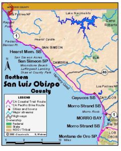
A winding gradual descent takes you to the San Luis Obispo County line at 10¼ miles where another fine view encompasses the nearer landmarks of Ragged Point, this section's destination, and wooded San Simeon Point beyond. Ascend the shoulder to 10½ miles, then descend moderately to 11⅛ miles. Contour to 11½ miles, then descend to the commercial oasis of the Ragged Point Inn at 11¾ miles. With the most services since Gorda, it also has a public path down past a waterfall to a small sandy beach and rocky shore, but no access up or down coast. Follow the highway south with the rugged Big Sur terrain falling behind you. After a nearly level mile, descend steadily to San Carpoforo Creek at 13¼ miles. Where the highway crosses the broad deep valley only 20 feet above sea level, you can see the breakers ⅜ mile west. It's signed "NO TRESPASSING" however, and even if you walk to the beach, it takes serious scrambling on steep slopes to get over Ragged Point ⅜ mile south. Ascend the highway west to a wide turnout at 13¾ miles, marked Milepost 70.8. It has an obvious path heading west, with no sign limiting access, but all forks end in thick chaparral. Walk the highway 250 feet south to a smaller turnout on the west shoulder, this section's end.
ALTERNATE ROUTE: One can walk the twisting Highway l shoulder of the wilderness.
SUGGESTED ROUND TRIPS & LOOPS: Hike the first 2 to 4 miles, returning the same way. Hike north from Salmon Creek Station or Soda Springs Trailhead to Buckeye Camp and return, 6¾ miles round trip.
Distance: 13¾ miles, with 7⅞ miles on Cruikshank and Buckeye Trails (22.1 & 12.7 kms).
Open to: Hikers. Dogs, horses allowed in Silver Peak Wilderness. Bicyclists on highway.
Surface: Trail, highway shoulder.
Access point: Cruikshank Trailhead.
How to get there: Park on east side of Highway south of Gorda at Milepost 6.5.
Other access: Soda Springs Trailhead, Alder Creek Camp off Willow Creek Road, Salmon Creek Ranger Station or anywhere south from there on highway.
Difficulty: Moderate
Elevation gain/loss: 3150 feet+/3300 feet- total. 2450 feet+/2|60 feet- for trail portion, 2190 feet+/350 feet- to Buckeye Camp.
Cautions: Watch for poison oak and ticks on trail, carry long pants for brush. Always purify water in the wilderness. First mile can be hot on a summer afternoon. Trail from 3 to 4 miles is brushy and hard to follow. We urge you travel with a friend, carry map and compass, pay close attention there and leave time for route finding.
Further information: Los Padres National Forest, Monterey District (831)385-5434.
Facilities: None at access point or anywhere along trail (except water at camps, which needs to be purified) or highway until Ragged Point Inn, which has phones and gas, food and lodging.
Campgrounds: Trail camps at Lower and Upper Cruikshank Camps, Buckeye Camp. Car camping to north at Plaskett Creek on Section 14, south at San Simeon State Park at end of San Luis Obispo Section 3.
Lodging: Ragged Point Inn en route in northern San Luis Obispo County has 19 moderately priced rooms. Other lodging available at Gorda on previous section.
Points of Interest

In the News
Interested in contributing to this project?
Register to add new photos and information, update existing results and share your trip reports.