
~Richard Nichols
Distance:
5 miles one-way; shuttle required or R/T; fee to park at Gerstle Cove.
Location:
Salt Point State Park is on Sonoma County’s north coast.
Hazards:
Poison oak, ticks, steep cliffs, “sleeper waves”, unmarked routes and trails.
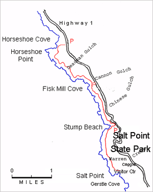
How to get there:
Salt Point State Park is located about 23 miles north of Jenner on Highway One. Go past the campground entrance for 4.2 miles and park on the west side shoulder. An unmarked trail drops off the road shoulder downhill towards the shore.
Hike description:
I’ve walked numerous coastal trails in California with favorites in all parts of the state. One of the very best walks is in my home county of Sonoma at Salt Point. Some of this route is just that, a cross-country route ripe for a signed footpath. The trail follows the bluff edge for most of the way, offering great views, a rugged shoreline washed by powerful Pacific combers, a bishop-pine forest and even a small, sandy pocket beach. Small details such as flowers, and big details such as whale sightings, abound on this walk. Evidence of human history, from why it’s called “Salt Point”, to “doghole” ports, also abound.
From the highway, the trail drops about 1/4 mile to the bluff overlooking beautiful Horseshoe Cove framed by Horseshoe Point to the southwest. From the overlook, go east cross-country next to the shallow ravine for a few hundred feet until you can cross it, and then head up through the grassland towards the low saddle between the point and the hills. Youll reach a faint old farm road running at the base of the low hills in front of you; the road leads up through the pass. As you descend though the pass, swing right steeply on the south side of the point and head for the bluff where you’ll find a wildly rugged shoreline at about 1/2 mile. Before heading south on the bluff, explore the fantastically shaped sea washed rocks.
The rest of the hike takes you along the bluff, which soon reaches historic Fisk Mill Cove. Stay near the bluff and cross several ravines. After the 3rd ravine look for a small pioneer cemetery in the trees. Cross another deep tree lined ravine at about 2 miles and climb steeply through bishop pine forest. Follow the sometimes-faint path then emerge onto coastal grasslands before descending to the deeply indented Stump Beach. The cliff here is high and vertical, so beware. Enter trees and look carefully at 3 1/4 mile for the steep trail descending to the beach and take care not to start down until you are sure you have the path. After a few hundred feet of sand cross the shallow creek and follow the rough path angling west up the bluff. You can also shorten this hike by taking the path 1/4 mile from the beach to a parking lot.
The rest of the hike stays on the bluff overlooking a rugged rocky shoreline. Just before reaching the parking lot, look for squared off stones lying in the grass, the result of a quarrying operation at the sea stack nearby. The stones were hauled to the nearby Gestle Cove where they were loaded on coastal schooners and taken to San Francisco. The hike ends at the Gerstle Cove parking lot at about 5 miles. An a-frame visitor center sites on the bluff above the cove.
Several other great hikes in this same area: a loop at Kruse Rhododendron Reserve, and several loops of different lengths from the CCT up the ridge to an interesting pygmy forest. Get a map of Salt Point State Park at the campground entrance for these trails.