
Usage Notes

Legend: For details on the icons and trail colors, please click the legend icon on the map above.

Layers: Other layers are available. See the California Coastal Commission and Coastal Conservancy Completed Sections layer for the official completed trail segments. (About progress on the trail completion project.)
Sonoma Section 4
Salt Point State Park to Fort Ross
This hike leads from one of the most scenic state parks on the coast to one of the most dramatic historic parks in the state, Fort Ross. Here the CCT offers a mixed bag of unmarked trails and highway shoulder with intriguing stops along the way.
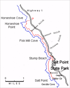
From the trailhead at the south end of the lot, walk south onto the point and head northeast toward Gerstle Cove. You soon cross the paved access road to the cove. Climb north on a dirt road, then turn right on a path paralleling a paved road and reach the A-framed visitor center at ¼ mile.
The Gerstle Cove Visitor Center overlooks the placid cove often busy with skin and scuba divers. Since the cove is a marine reserve, divers can look but not take. The trail leads from the front of the visitor center southeast into the trees, then crosses a bridge over a gully and follows the bluff above the cove. A wildfire burned this entire area in 1995. It's a good place to watch this forest and terrace recover. The CCI meanders along the marine terrace, coming to a parking area at the end of the road at ⅝ mile. From here a dead-end side trail explores the shore to the south. It passes a gate, dips through a gully and crosses the terrace. Around ⅝ mile, the path ends at steep cliffs overlooking a rugged coast. You can turn inland here and hike cross-country to the highway about ⅜ mile uphill. It's easy to get lost in the thick undergrowth and drift onto adjacent private property, so we don't recommend this route.
From the parking area at the end of the road, walk a few yards up the road and take the trail climbing northeast through more burned-over forest. At an unmarked junction at one mile, turn right and follow the path through the woods, coming to the highway at 1⅜ miles. Cross the highway and take the path uphill toward Woodside Campground. At 1⅝ miles you reach another unmarked junction just before the campsites. Turn right and follow the trail below the power lines through thick Bishop pine forest. That trail ends at a fire road at 2 miles. Turn right on the fire road, quickly descending to the highway where you turn left to follow its shoulder. Use extreme caution walking this narrow section of highway. At 2⅝ miles reach the Ocean Cove Store, a good place for a break. You can pay an entrance fee here and walk through the private campground to the Stillwater Cove Park boundary at 3 miles. Otherwise, walk the road ⅛ mile, then turn right after passing the private land, descending toward the shoreline at 3 miles. An informal trail follows the bluff overlooking a rugged series of points and coves and returns to the highway at 3½ miles.
CCT follows the narrow highway shoulder down to the Stillwater Cove shortterm parking area. A short side trail on the right heads down past a grove of fantastically gnarled redwoods to the restroom and picnic tables beside the cove. From the short-term parking, cross the highway, then ascend the stairs up the canyon wall to the parking lot, then take the entrance drive out to the highway. If the stairs are closed you must cautiously walk the narrow highway shoulder. From the park south the land is part of the Timber Cove subdivision and posted "NO TRESPASSING." At 5 miles Timber Cove Lodge perches on a point. Behind the lodge on the tip of the point sits California's smallest state park. It's ¼ acre holds a 100-foot-tall Benny Bufano statue. You can reach the statue by taking the access road that rounds the lodge's north end and turns south behind it, leading to the statue. Return the same way.
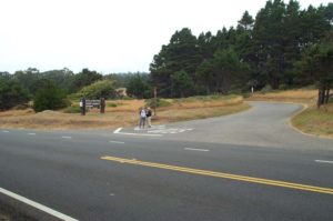
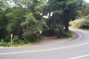
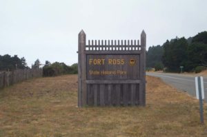
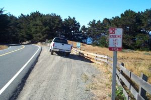
CCT continues south on Highway l's shoulder past a private campground. After passing the Fort Ross Store at 5⅞ miles, take the gravel road on the right that heads out to Windermere Point, once the site of a lumber mill but now vacant and publicly owned with a great view north. Swing around the point and return to the highway at 6⅜ miles. Cautiously follow the narrow shoulder down to Kolmer Gulch. As you climb out of the gulch, the highway reaches a graded notch in low hills. Step over the old fence here around 6⅝ miles and descend the faint trail angling south to the bluffs. Then follow the bluff's edge toward Fort Ross. The trail winds over the grassy terrace past scenic points and coves and wind- and wave-carved tidal rocks. It heads south to Northwest Cape at 7¾ miles, then turns east and traces the edge of the cliffs overlooking Fort Ross Cove. The trail rises through low, rounded hillocks to a gate at 8 miles, crosses the fort's access road, then runs along the edge of the large parking lot, arriving at the Fort Ross Visitor Center at 84 miles.
SUGGESTED ROUND TRIPS & LOOPS: For an easy round trip of about 1¼ miles, walk south from South Gerstle Cove to the southern park boundary and back. Stillwater Cove Park has a nice short trail up Stockhoff Creek, a fine coastal creek lush with redwoods and ferns. From Fort Ross you can walk the Coastal Trail northwest to the highway and back, 3¼ miles round trip.
Distance: 8 ¼ miles (13.7 kilometers)
Open to: Hikers, Bicyclists
Surface: Trail, highway shoulder
Access point: Salt Point Parking Lot
How to get there: Salt Point Parking Lot
Other access: Either of Salt Point Campgrounds, Stillwater Cove Regional Park, or anywhere along the highway.
Difficulty: Moderate
Elevation gain/loss: 720 feet +/600 feet-
Cautions: The trail from Salt Point to the highway is mostly unmarked.
Further information: None.
Facilities: Water, restrooms, and picnic tables at access point, Gerstle Cove and Fort Ross. Latter two also have visitor centers.
Campgrounds: Salt Point State Park campgrounds, Stillwater Cove Regional Park campground, two private campgrounds south along the highway.
Lodging: Several lodges are on the route along Highway 1.

Interested in contributing to this project?
Register to add new photos and information, update existing results and share your trip reports.