
Usage Notes

Legend: For details on the icons and trail colors, please click the legend icon on the map above.

Layers: Other layers are available. See the California Coastal Commission and Coastal Conservancy Completed Sections layer for the official completed trail segments. (About progress on the trail completion project.)
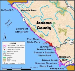
Sonoma Section 5
Fort Ross State Historic Park to Russian Gulch
This hike begins with an easy walk through the historic Russian fort to scenic Fort Ross Cove, gets rougher climbing over bluffs to Reef Campground, then explores one of the roughest and most remote areas on the California shore, Sonoma's Lost Coast. This dramatic terrain results from the proximity of the San Andreas Fault, which comes ashore amidst these high bluffs, causing this land to rise steeply from the sea. Most of the hike follows the base of cliffs far below the highway where you must scramble over rocks, walk on slippery, uneven cobbles, and make several steep climbs and descents. It's a stimulating trek for fit hikers, passable only in calm weather when the tide is ebbing. Sonoma's Lost Coast has a wilderness feeling. An Alternate Route follows the highway.
Start at the Fort Ross Visitor Center where excellent displays discuss the Kashaya Pomo, Russians and Americans who lived on and worked this land. Walk through the museum if it's open, or around to its right if it's closed and descend the paved path through a cypress grove past historic Call Ranch buildings to the fort at ¼ mile. Fort Ross testifies to the hardships and ingenuity, but ultimate failure, of the Russians who tried to settle here.
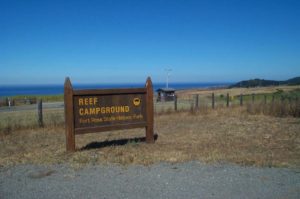
From the fort's southwest corner, the trail winds down the bluff to Fort Ross Cove beyond ½ mile. Walk the cove's beach, passing a side trail on the left to the old Russian cemetery. CCT climbs the narrow path up the bluff, reaching the top at ¾¾ mile. Follow the trail along the bluff's edge, descending to the end of the Reef Campground road before 1⅛ miles where you'll find water and an outhouse, the last of civilization for the next 5¾ miles. Cross the small dirt parking area, hop over the stile and descend the trail to the rocky beach.
At 1¼ miles you reach a rocky point impassable at high tide. If this is the case, climb the crumbly bluff 80 feet to a broken down fence along a hogback. Walk up the fenceline to the top of the bluff at 1½ miles and find the rough trail angling back down to the beach. Use caution on this detour. Head south along a beach of large rocks. Beyond piles of driftwood around 1⅞ miles, walk a beach of smaller rocks. Round a sandstone shelf and pass the mouth of Mill Gulch. The beach narrows at 2⅛ miles.
The beach turns east to meet the heart of the San Andreas fault at 2½ miles, marked by the huge slide of gray mud on the cliff. The rock is fractured so severely here it's reduced to pulverized clay called mylonite. You leave the Pacific Plate for the North American Plate in the next ¼ mile as the sand becomes dark. Pass Timber Gulch at 2¾ miles.
Reach a narrow spot beyond 3 miles passable only at tides less than 4.5 feet. The dark sandy beach offers welcome relief from rock hopping. The sand ends around 3⅝ miles, and at 3⅞ miles a steep side trail climbs to the highway far above. Scramble over a jumble of rocks at 4 miles, then descend to a rocky beach. The beach provides easy walking to 4⅔ miles, where you need a medium tide to proceed. Then walk a broad sandy beach past seeps and a steep gulch.
At 4¾ miles you must scramble over a rocky point. Pick your way to the top, then scramble down large rocks to the beach. More easy beach walking ends at a narrow spot where cliffs crowd the beach at 5¼ miles. Climb over a rock shell and walk a gravelly beach. Where you pass two gigantic sea stacks at tideline around 5⅜ miles, pick your way over uneven terrain, scrambling between massive rocks and hopping over tidepools.
Walk the beach to a huge, domed rock outcrop jutting seaward at 5¾ miles. To continue you must carefully scramble up the steep chute between the outcrop and the precipitous headlands. Reach the top 75 feet above the beach on a narrow hogback. then use extreme caution scrambling steeply down the other side. Though not a technical climb, we don't recommend it for anyone afraid of heights.
Walk a small rocky beach briefly followed by a long sandy one, interspersed with short rock scrambles. After a big sea stack at 6¼ miles, pass a beautiful sandy-bottomed tidepool. You can explore it at low tide or take a cooling dip on a warm day.
The beach ends at 6⅜ miles at the south end of the cove. The trail climbs a steep crumbly 200-foot bluff on an informal but well-used trail. To get to it, walk 100 feet on tidal rocks from the end of the cove to where the cliff is sloughing, less steep than the surrounding slope. Stay on the path others have created. At the top the views of the coast you just walked and south to Bodega Head are stunning. The well-worn trail follows bluff's edge overlooking a pocket beach, then turns inland at 6 miles, angling downhill toward the gravel Russian Gulch parking area. The trail passes a grassy area above the beach then goes through coastal scrub thick with poison oak, ending at the parking lot at 6⅞ miles.
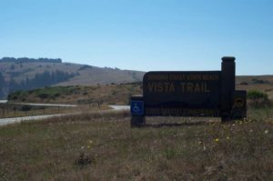
ALTERNATE ROUTE: From the end of the Reef Campground road walk up the canyon one mile to Highway 1, then turn right and walk the highway shoulder. It climbs to 600 feet above the water for stunning views, passing the ¾-mile wheelchair accessible Vista loop Trail at 5¾ miles, then drops to Russian Gulch at 7½ miles.
SUGGESTED ROUNDS TRIPS & LOOPS: From the visitor center explore the fort and Fort Ross Cove, then walk south to Reef Campground and return for an easy 1½ miles round trip. A short side trail leads from Fort Ross Cove uphill to the historic Russian cemetery.
Distance: 6 ⅞ miles (11.1 kilometers)
Open to: Hikers
Surface: Trail, beach, rocky tideline
Access point: Fort Ross Visitor Center
How to get there: Turn west off Highway 1 12 miles north of Jenner at Milepost 33.00 into Fort Ross entrance and park at the visitor center lot.
Other access: Fort Ross Reef Campground.
Difficulty: Hard
Elevation gain/loss: 470 feet +/560 feet-
Cautions: Hike requires boulder hopping, walking uneven beaches, and steep climbs and descents. It is only passable at a 3.0 foot or lower tide in calm weather. Wear sturdy boots and don’t go solo.
Further information: https://www.youtube.com/watch?v=WYwJn_96v0k
Facilities: Fort Ross has water, phone, restrooms, and picnic tables. Chemical toilets at Fort Ross Cove, Reef Campground (water too), and Russian Gulch.
Campgrounds: Reef Campground is 1.6 miles south of the For Ross entrance.
Lodging: Several motels are north of Fort Ross.


Interested in contributing to this project?
Register to add new photos and information, update existing results and share your trip reports.