~John Krist

Distance: 3.4 miles, out and return; easy
Child rating, 5 and up
Location: On the coast to the west of San Luis Obispo and south of Morro Bay, the park is located southwest of the town of Los Osos. Follow Pecho Valley Road from Los Osos to the park entrance.
Hazards: Poison oak, ticks and though seldom seen, rattlesnakes.
The Diablo Canyon nuclear power plant is less than 4 miles to the south. The plant’s presence is responsible for the warning signs located at various places throughout the park telling visitors what to do if they hear a loud and steady siren blast for 3 to 5 minutes (tune radios to 920 or 1400 AM, or 98.1 FM, for information).
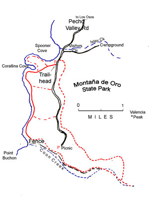
How to get there: The trailhead is a dirt pullout on the west side of Pecho Valley Road about 100 yards south of the entrance to the campground and visitor center. Park there or in the visitor center lot.
Hike description: The trails of Montaña de Oro offer a range of experiences, guaranteeing something for just about everyone. Those who want expansive views will find routes leading to the tops of rocky peaks; wildflower fans will find what they seek in the hilly inland meadows; those in search of bird and marine life will find it along the bluffs that look out over the surf and the rock coves. This easy route along a broad terrace overlooking the sea offers a chance to enjoy Montaña de Oro’s lovely scenery and remarkable array of wildlife without much exertion, and provides a perfect outing for those with young children, limited time, or both.
Follow the well-defined trail as it crosses a wooden bridge and leads toward the ocean. Stay left at the first fork just beyond the bridge. The trail is broad and easy to follow, receiving a great deal of use from hikers and bicyclists. It crosses a broad meadow carpeted with hardy grasses, wild radish and New Zealand spinach, passes a pair of outhouses at 0.3 mile and reaches a junction with a trail that crosses a bridge to the right and heads back to Spooner Cove. Stay to the left, reaching the edge of the bluffs above Corallina Cove at 0.6 mile. The cove contains rocky reefs with many tidepools, and often boasts a population of harbor seals. Watch also for the occasional sea otter floating on its back between the surf and the kelp line, balancing a rock on its chest and using it to crack the shells of its favorite foods: crabs, mussels, abalone, lobsters.
The trail turns south here and parallels the edge of the bluffs, crossing paths every quarter-mile that lead back to the park road. At 1.7 miles the trail reaches a steel fence marking the park boundary. Grotto Rock, a castle-shaped prominence with sea caves eroded into its face, is to the right; beyond the fence lies the mouth of Coon Creek, Point Buchon and the property of Pacific Gas & Electric Co., which operates the Diablo Canyon nuclear power plant.
Options: The trail offers a variety of side routes and alternatives, including the option to follow the trail as it swings east, and continue far inland before returning to the Visitors Center. These as well as 5 other hikes in Montaña de Oro Park are described in Krist?s book, 50 BEST Short Hikes in California?s Central Coast.
Adapted from 50 BEST Short Hikes in California?s Central Coast by John Krist. Used with permission of the author and WILDERNESS PRESS. All rights reserved. Photo of Spooner Cove by Nancy Graves. Other hiking books by John Krist: 50 Best Short Hikes in Yosemite and Sequoia/Kings Canyon and 50 Best Short Hikes in California Deserts.
Beyond his outdoors books, John Krist is an environmental writer whose work regularly appears in the Ventura County Star and is distributed nationally. He is also a contributing editor for California Planning & Development Report and his work is frequently seen in the High Country News. For his book Voyage of Rediscovery: Exploring the New West in the Footsteps of Lewis & Clark, he traveled for 3-months and 15,000 miles. A related work, presented on the web, won a first place award in the 2003 EPpy competition.
