
Usage Notes

Legend: For details on the icons and trail colors, please click the legend icon on the map above.

Layers: Other layers are available. See the California Coastal Commission and Coastal Conservancy Completed Sections layer for the official completed trail segments. (About progress on the trail completion project.)
Del Norte Section 7
Damnation Creek Trail to Lagoon Creek, Redwood National Park
In this section CCT runs east of Highway 101 for its longest stretch in northern California, something the trail will not repeat until well into southern California. Even with this eastward jog, you're never more than a mile from the Pacific. The first half of this section provides CCT's most intimate exploration of a virgin redwood forest. While other sections visit virgin redwood groves, here you traverse virgin forest for 4 miles on a scenic new track that takes you through one giant tree and winds under and around many others in diverse terrain, allowing you a hand in glove experience of an ancient redwood forest. Consider a stay a at DeMartin Camp, a walkers-only stopover where you can absorb the mysteries of the ancient forest round the clock. Or opt for beds, hot water and fellowship at Redwood Hostel in a 19th-century homestead farther along the route.
Day hikers follow the Damnation Creek Trail from Highway 101. It climbs over a ridge and drops through virgin forest to meet CCT in ⅝ mile. Turn left to follow CCT south. The mileage for this section starts counting from that junction. CCT follows the pavement that was once Highway 101, winding south through a virgin a forest ol massive redwoods. After descending to a big bend at ⅜ mile, the road contours with glimpses of the rugged coast below.
Watch carefully on the left at 1⅛ miles for a narrow footpath. If you miss it, the old pavement merges with Highway 101 in 200 feet. CCT follows the footpath over a small ridge and down to the highway at 1¼ miles. Since there is no crosswalk across the busy road, use extreme caution crossing to the other side to find a "CCT" sign marking the start of the DeMartin Section.
The trail descends by steps and switchbacks to a bridge at 1⅜ miles, then zigzags up through the forest to 2 miles. CCT reaches this section's summit and turns south to follow the lush coastal ridge where rhododendrons abound. Follow the winding ridge around: gulch at 2¼ miles.
After passing through a walk-through redwood, CCT leaves the ridge around 2⅜ miles, descending south by switchbacks on new tread completed in February 1998. Cross the head of a gulch, then contour southeast through more virgin forest, winding through two more gulches. Beyond 2¾ miles your trail climbs east to 3 miles. Contour south, winding through the heads of four more gorgeous gulches to 3½ miles. Then CCT climbs moderately east to a summit at 3¾ miles, a hill 1020 feet above sea level.
Descend steeply south, dip through a gully, then climb briefly through a a pleasant grove to the coastal ridge at 4⅛ miles. As you descend south along the ridge, the forest thins to reveal the spectacular coast beyond giant Douglas firs with False Klamath Cove and False Klamath Rock in the foreground, Patrick's Point and Cape Mendocino stretching westward beyond. Continue a winding descent to a junction at 4⅝ miles.
The Coastal Trail turns left for a short climb to DeMartin Camp at 4¾ miles. The pleasant camp perches on the edge of deep forest overlooking DeMartin Prairie. Its ten sites offer tables, fire rings, and a composting toilet, but no drinking water. If you stay here, you need to stOW your food in the metal bear boxes provided to keep Yogi and BooBoo Bear out of trouble!
CCT ascends briefly through the spruce and alder forest before descending through the heart of DeMartin Prairie. From 5 miles your descending track drops alternately through forest and prairie. At 5¼ miles you dramatically approach the edge of deep Wilson Creek Canyon, the private lands of which have been logged. Your descent continues, winding and switchbacking through charming forest. Beyond 5¾ miles the path levels briefly then ascends along a narrow ridgetop with views of the ocean through the forest, culminating in a grand vista of towering Footsteps Rocks along the rugged shore. Return once more to the edge of Wilson Creek Canyon, then climb to contour around a big rock outcrop beyond 6¼ miles.
Resume a winding descent to 6½ miles before CCT straightens out, then bends sharply right to follow an old road briefly. Fork right along a footpath through coastal scrub, soon bending left to descend along a power line. Open country provides views of False Klamath and Wilson Rocks offshore. After a series of long switchbacks, CCT drops into forest at 7 miles, making a winding a descent that crosses eight small boardwalks.
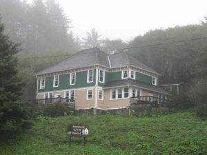
Your trail levels at 7⅜ miles, coming to an overgrown stretch of old highway and a trail junction. In summer you'll want to take the footpath on the far side of the old road, descending to ford Wilson Creek below the highway bridge in ⅛ mile. At times of high water, however, turn right and follow the old pavement uphill 500 feet to Highway 101, then turn left to cautiously cross the highway bridge. At the south side of Wilson Creek, Redwood Hostel occupies the pioneer DeMartin House east of the highway. Wilson Creek Beach is west of the highway. The main route of CCT heads south along Wilson Creek Beach for ⅝ mile to the mouth of Lagoon Creek and Del Norte Section 8. At high tide however, especially in winter, the center portion of the beach may not be passable. In that case you have two choices. 1) Walk the highway shoulder for about ½ mile to the mouth of Lagoon Creek where you can return to the beach. 2) Take the Alternate Route to meet Del Norte Section 8 one mile from the starting point, a route one mile longer.
ALTERNATE ROUTE: From the hostel south, you can also walk the Hostel/Trees of Mystery Trail east of Highway 101. Walk east 150 feet from the base of the hostel's front steps to find the trail's signed north end. The trail follows a gravel road, ascending then contouring through forest with occasional coastal views. The road becomes less traveled as you cross three forks of Lagoon Creek before 1⅛ miles. Then contour a along a grassy track through lush undergrowth. At 1¾ miles it descends to the Trees of Mystery parking lot. Unless you crave pavement, veer left on the footpath above the lot which ends in ⅛ mile at the Trees Gift Shop. Here you'll find a great museum of Native American artifacts plus restrooms and a pay phone. Take the crosswalk to cross Highway 101, then turn right and walk in front of the motel to a clearly signed gravel path. Follow it west ½ mile to meet Del Norte Section 8 just south of Hidden Beach. Total distance is 2½ miles.
SUGGESTED ROUND TRIPS & LOOPS: It is a rewarding, spectacular hike to DeMartin Camp from either the north or south end with views more rewarding on the south part and the virgin forest the dominant feature on the north part.
Distance: 8⅛ miles (CCT) or 8¾ miles from Damnation Creek Trailhead (13.1 or 14.1 kilometers).
Open to: Hikers.
Surface: Trail, beach.
Access point: Damnation Creek Trailhead.
How to get there: On west side of Highway 101, 10 miles south of Crescent City (Milepost 16.0).
Other access: Wilson Creek Beach west of DeMartin Redwood Hostel.
Difficulty: Hard
Elevation gain/loss: 670 feet+/1530 feet-. If starting from Damnation Trailhead add 40 feet+/140 feet-.
Cautions: Use caution crossing Highway 101.
Further information: Redwood National and State Parks (707) 464-6101, ext. 5064.
Facilities: None at access point. Chemical toilets but no water at DeMartin Camp. Phone at Redwood Hostel. Picnic area, water, restrooms at Lagoon Creek.
Campgrounds: DeMartin Camp (walk-in) is near middle of section. Car camping at Del Norte Coast Redwoods State Park north of access point.
Lodging: Motel Trees is just south of south end of section. Other lodgings are in Crescent City to the north and Klamath to the south. DeMartin Redwood Hostel (707)482-8265 is near south end of section.

Interested in contributing to this project?
Register to add new photos and information, update existing results and share your trip reports.