
Usage Notes

Legend: For details on the icons and trail colors, please click the legend icon on the map above.

Layers: Other layers are available. See the California Coastal Commission and Coastal Conservancy Completed Sections layer for the official completed trail segments. (About progress on the trail completion project.)
Humboldt Section 7
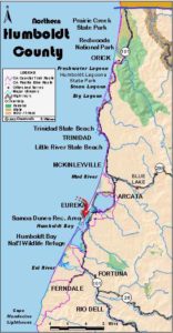
Mad River County Park to Manila
While Mad River County Park consists of only 150 acres of dunes south of the Mad River mouth, it provides access to the 11 miles of continuous beach stretching south to the mouth of Humboldt Bay. If you have time, visit the Nature Conservancy's Lanphere-Christensen Dunes Preserve two miles south of Mad River County Park for a look at undisturbed dunes habitat.
From the parking area, follow jeep track west-northwest through low dunes, coming to the tideline in about ⅛ mile. Head south along the firm sand just beyond the reach of the waves. By ½ mile the beach turns broader than at the start with high dunes to the east. Beyond one mile much large driftwood lies along the beach. At 1½ miles a pole stands atop the dune nearest the beach. A double track heads east into the dunes at 1⅝ miles where two large driftwood stumps lie at tideline. Continue along the unbroken beach.
Around 2 miles the dunes to the east stand about 70 feet tall. From 2¼ miles the protected habitat of the Lanphere-Christensen Dunes Preserve lies to your east. The preserve encloses the tallest dune, an 81-foot sandhill ⅜ mile east. Mad River Slough, an ancient outlet for the river when it flowed into Humboldt Bay, lies east of the preserve. The beach walk parallels the preserve until 3⅜ miles. The long beach walk continues with little notable change, low dunes rising on your left, breakers rolling in on your right.
By 5 miles you may notice a gap in the dunes to your east. You are now on the Samoa Peninsula, a half-mile wide sand spit between the Pacific Ocean and Humboldt Bay. Continue along the beach for another mile. You've left most of the agricultural lands behind. Now the small town of Manila lies to the east.
At 6 miles the CCT continues along the ocean beach. Although this section of the Coastal Trail ends, you have the option of turning east into the dunes to reach the section's south end access. To do so, look for broad, sandy path east through a low point in the dunes. It's hard to spot on the long, straight beach. Follow it east ⅜ mile to the Manila Community Center in the old Manila School.
ALTERNATE ROUTE: For through-hikers, the pressing problem of Humboldt Section 8 to the south lies in the deep water crossing at the mouth of Humboldt Bay. To make the crossing you must arrange a boat before you arrive. If you are unable to arrange a boat, you'll need to leave the CCT at Mad River County Park or the Hammond Bridge. From the Hammond Bridge follow the Hammond Trail to Arcata, then walk east on 7th Street to head south on Bayside Road, Old Arcata Road and Myrtle Avenue to circle Humboldt Bay to Eureka. As you enter town, turn left on Hall Avenue, then follow Harris Street west to F Street. Walk south on F, which eventually becomes Fairway Drive. Follow it to its end, then walk Herrick Avenue west to Highway 101. Follow Highway 101, South Broadway and Humboldt Hill Road south to the Hookton Road exit which leaves Highway 101 6¾ miles south of Herrick. Then walk Hookton Road and Table Bluff Road 5½ miles to return to CCT at the base of Table Bluff in Humboldt Section 9. It's a long 30- to 35-mile detour, bypassing 18¼ miles of CCT. The town portion is not very pleasant compared to the CCT route and a boat crossing of the mouth of Humboldt Bay, but if you must walk through town you can compensate with a meal out and maybe an espresso drink or some other decadent town treat.
SUGGESTED ROUND TRIPS & LOOPS: Walk south along the beach from Mad River County Park for as long as you like, or walk north along the beach from the Manila Community Center at the south end.
Distance: 6 miles of CCT, 6⅜ miles to south end access (9.7 or 10.3 kilometers). OPEN TO: Hikers, equestrians.
Open to: Hikers, equestrians.
Surface: Beach.
Access point: Mad River County Park.
How to get there: Exit Highway 101 north of Arcata onto Janes Road at Milepost 89.05 from north, Milepost 88.5 from south. Go west on Janes Road, then right on Heindon Road for 4 mile. Go left on Miller Lane for .7 mile. Then go right on Mad River Road, coming to Hammond Bridge in 1.7 miles. The road turns west following the CCT route (Section 6) to the parking area and access point in I. I miles (4 miles from Highway 101).
Other access: Lanphere-Christensen Dunes Preserve, call for permission (707) 822-6378.
Difficulty: Easy
Elevation gain/loss: 10 feet- for CCT, 60 feet+/50 feet- to Community Center.
Cautions: Watch for off-road vehicles on the beach.
Further information: Humboldt County Parks (707) 445-7652. For boat shuttle call Humb Boats (707) 443-5157.
Facilities: Chemical toilets, picnic area.
Campgrounds: Clam Beach County Park allows overnight stays. Several private campgrounds in Arcata area.
Lodging: Arcata has numerous motels.
Points of Interest

In the News
Interested in contributing to this project?
Register to add new photos and information, update existing results and share your trip reports.