
Usage Notes

Legend: For details on the icons and trail colors, please click the legend icon on the map above.

Layers: Other layers are available. See the California Coastal Commission and Coastal Conservancy Completed Sections layer for the official completed trail segments. (About progress on the trail completion project.)
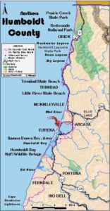
Humboldt Section 6
Trinidad to Mad River County Park
The longest section yet on CCT offers both great variety and a major transition in geography. While Trinidad is one of the smallest incorporated cities in California, as well as one of the oldest, it offers a supermarket and three good cafes. Trinidad must also have one of the highest concentrations of trails among America's small towns. You might take a side trip or two to further explore this dramatic meeting of land and sea.
Less than 4 miles south of town the rugged rock-studded shore suddenly yields to a 19-mile beach sprawling south-southwest to the mouth of Humboldt Bay. The inland terrain changes dramatically as well, with the mountainous landscape to the north yielding to low marine terraces and bayside bottomlands. Most of this section consists of easy walking along the beach and the firm treaded Hammond Trail, which follows an old railway along the Mad River. Here you'll see locals enjoying their shoreline access.
Before section's end, through-hikers need to make a decision. To follow Humboldt County Sections 7, 8 and 9 in sequence, you'll need to arrange a boat shuttle across the mouth of Humboldt Bay. Otherwise you must make a major 35mile detour into and through Arcata and Eureka with no chance to rejoin CCT until 18¼ miles down the trail.
The Coastal Trail follows city streets out of tiny Trinidad. Walk Edwards Street east one block to its end, then walk north two blocks on Ocean Street to Main Street. Turn right and follow Main east two blocks to the Highway 101 interchange where CCT turns right to follow Scenic Drive south.
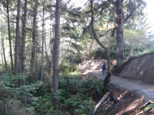
Walk the road shoulder through a wooded gully and over a bluff. After a glimpse of the ocean around ¾ mile, follow the road winding east and south, dipping across McConnahas Mill Creek at one mile, then winding through the Trinidad Indian Reservation. At 1⅜ miles you get your first sweeping vista of rock-studded Trinidad Bay.
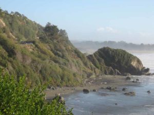
The next part of Scenic Drive is prone to slip-outs. After a one-lane stretch of road, pass the Baker Beach side trail at 1⅞ miles. It descends 350 feet to secluded Baker Beach. Continue along Scenic Drive over Sotsin Point and to a turnout at 2 miles with a sweeping view from Trinidad Head to Samoa Peninsula . Descend to Luffenholtz Creek, then climb to Luffenholtz County Park around Tepona Point at 2½ miles. A side trail from the north end of the parking lot drops to a beach.
Another spur leads to the tip of the point. Follow Scenic Drive south over another slip-out at 2⅝ miles.
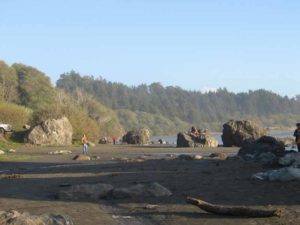
Scenic Drive tops cypress-shrouded Houda Point at 2⅞ miles where another spur descends stone steps to a beach beside towering Little River Rock. The beach is expansive at low tide, narrow or submerged when the tide is in. Continue south on Scenic Drive as it climbs steeply to a final vista at 3 miles. Then follow Scenic Drive as it winds east and descends to Moonstone Road at 3⅝ miles. Turn right and descend Moonstone Road to Moonstone County Park at 3¾ miles. At Moonstone the coast changes dramatically. Instead of the rocky, convoluted coast that has made CCT spectacular but difficult to follow for the past dozen miles, one virtually continuous beach stretches south for 19 miles. The Coastal Trail drops to the beach at Moonstone County Park with only two watery obstacles to your progress in those 19 sandy miles. The first obstacle is immediate. In only 300 leet you reach the mouth of Little River, highly subject to change. Sometimes you can easily ford the river near its mouth at low tide except at flood. If the tide is high or the ford too deep, you may need to wait for low tide, or you might be able to ford at the top of the beach as far from the mouth as possible. The second obstacle lies 3½ miles down the beach. The mouth of the Mad River is virtually always too deep to ford, but CCT follows the pleasant Hammond Trail east of the river.
From the parking lot at Moonstone County Park, walk the beach south or southeast to ford Little River, then continue south along the tideline. You walk through Little River State Beach until 5¼ miles where you enter Clam Beach County Park. You probably won't notice the change in jurisdiction until you reach the ford of Patrick Creek and Strawberry Creek around 6 miles (their confluence is on the broad beach). Overnight camping is allowed near the highway frontage road not far to the east.
Follow the tideline to 6½ miles where the shoreline makes a significant indentation for ⅛ mile. Continue along the shoreline to 7⅛ miles where the trail turns inland. You may see a rock jetty that protects Highway 101 from the fickle currents of the Mad River in the shifting dunes near its mouth, or the jetty may be buried in sand. Follow the beach southeast, then walk south on the level shelf east of the Mad River. The Hammond Trail has not yet been completed this far north, but it's mostly easy walking on a two-lane track. Plans for the Hammond Trail include bridging Widow White Creek upstream from the current ford and extending the developed trail north to the jetty.
At 8⅜ miles you must ford Widow White Creek. The ford is passable except after major storms. Follow the river bank about 700 feet, then jog east up to the Hammond Trail. Follow the trail south along the east bank of the river, passing the Murray Road access at 8¾ miles, where a short spur descends to the river. Then follow the Hammond Trail as it veers away from the river, passing residences. Cross Knox Cove Drive, then follow paved trail to Hiller Park at 9⅝ mile where you'll find restrooms, water and picnic tables. CCT crosses Hiller Road as the trail becomes more suburban. You soon follow a town street to School Street. Then follow a paved country lane down to the river's flood plain, coming to the Hammond Bridge across Mad River at 10⅞ miles.
Where the Hammond Trail meets Mad River Road south of the bridge at 11 miles, CCT turns west lo follow Mad River Road to its end at 12 miles at Mad River County Park, where CCT returns to the beach. For another way into Arcata along the Hammond Trail, see Alternate Route.
ALTERNATE ROUTE: At the Hammond Bridge, instead of walking west to Mad River County Park, you can follow the Hammond Trail, now bike lane, south on country roads into the town of Arcata, home of Humboldt State University. Il you're through-hiking and can't arrange a boat shuttle between Sections 8 and 9, you must go via Arcata.
SUGGESTED ROUND TRIPS & LOOPS: Day hikers might consider following the Hammond Trail north from the south end of this section or from the Hammond Bridge, also an excellent bike ride. Or ford Little River at Moonstone County Park and walk the beach to the mouth of Mad River, 6¾ miles round trip.
Distance: 12 miles (19.3 kilometers).
Open to: Hikers. Bicyclists on Scenic Drive and Hammond Trail. Equestrians on latter.
Surface: Road shoulder, beach, trail.
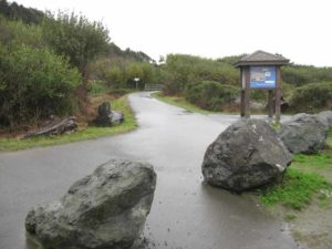
Access point: Downtown Trinidad.
How to get there: Exit Highway 101 north of Arcata at Trinidad, Milepost 100.9 from north, Milepost 100.6 from south. Go west on Main Street, then left on Trinity Street to its end at Edwards Street and park.
Other access: Scenic Drive, Moonstone County Park, Little River State Beach, Clam Beach County Park, Hammond Trail from Murray Road or School Road.
Difficulty: Easy
Elevation gain/loss: 325 feet+/490 feet-.To Clam Beach: 215 feet+/ 390 feet-.
Cautions: Little River is fordable only at low tide. Mad River is nearly always too deep to ford.
Further information: Trinidad Chamber of Commerce (707) 677-1610, City of Trinidad (707) 677-0223, Hammond Trail, Humboldt County Parks (707) 445-7652.
Facilities: Restrooms, water, phone, picnic area.
Campgrounds: Several private campgrounds are around Trinidad. Public campgrounds are at Patrick's Point State Park to the north, or overnight camping at Clam Beach County Park along this section.
Lodging: Several inns and motels are around Trinidad.

Interested in contributing to this project?
Register to add new photos and information, update existing results and share your trip reports.