
Usage Notes

Legend: For details on the icons and trail colors, please click the legend icon on the map above.

Layers: Other layers are available. See the California Coastal Commission and Coastal Conservancy Completed Sections layer for the official completed trail segments. (About progress on the trail completion project.)
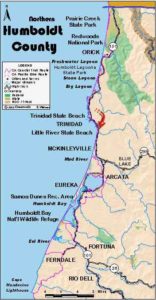
Humboldt Section 5
Sue-meg (formerly Patrick's Point) State Park to Trinidad
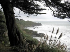
This section of CCT has three distinct parts. First, CCT follows the Rim Trail along the oceanside perimeter of beautiful, compact Sue-meg (formerly Patrick's Point) State Park, passing six spur trails that explore the convoluted shoreline more closely. One spur leads to Wedding Rock where on a clear day you can see Cape Mendocino 50 miles south. Two other park attractions merit a visit. From 287-foot Ceremonial Rock, you might see the mouth of the Klamath River 30 miles north. At the reconstructed Yurok village of Sue-meg on the park's east side, visit traditional dwellings like the ones local natives inhabited for millennia. The section's second and longest part is a pleasant road walk along not-too-busy Patrick's Point Drive and lightly traveled Stagecoach Road where you're almost always within hearing of the roaring surf with the Pacific often in view. It's great bike ride if you prefer a to follow the pavement on wheels. The section's third part traverses the length of 159-acre Trinidad State Beach, a little known but lovely stretch of coast.
Take the Rim Trail west, soon following a chain link fence that keeps foolish explorers off the dangerous steep bluffs to the north. You pass through berry thickets with views north over Agate Beach and northwest to Mussel Rocks. Enter dense forest around ¼ mile. Soon tiny Beaver Creek burbles on your left. Veer right to an overlook at bluff's edge, then wind left, crossing a bridge above a waterfall at ⅜ mile. After a tunnel of foliage, descend steps to Mussel Rocks spur trail (¼ mile round trip) on the right before ½ mile.
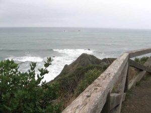
Rim Trail climbs steps, then turns south between two big rocks and descends to a picnic area. Head west past another coastal view to another picnic area at ⅝ mile. As you approach the Wedding Rock parking area, take the first right fork to avoid the congestion and descend to Wedding Rock spur trail. The spur drops then climbs to the top of Wedding Rock, a ¼-mile round trip.
CCT continues south on the Rim Trail, soon climbing steps to join a paved, a wheelchair-accessible path and to meet the Patrick's Point spur at ¾ mile. The paved spur forks right, descending to postcard vistas, a ¼-mile round trip. Follow the Rim Trail as it wraps around the base of Lookout Rock on your left, quickly passing the Lookout Rock spur, a ⅛-mile round trip.
The Rim Trail descends through spruce forest to cross tiny Ickie Ughie Creek, then climbs to the Rocky Point side trail (a ⅛-mile round trip). Rim Trail climbs to a spur to the hike/bike camps, then turns south through alder forest with views seaward. Pass a large cypress at one mile and continue along the western edge of Abalone Campground. A spur forks right at 1⅛ miles, dropping to Abalone Point, ⅛-mile round trip.
Follow the Rim Trail southeast along the wooded bluff and across a small bridge. As the dirt track ends at a paved trail, turn right and cross a bridge over Penn Creek, coming to a junction of three trails. CCT leaves the Rim Trail here, turning left on the dirt path that heads east and north to the park entrance.
You can take one more side trip of a mile or more to Palmer's Point, the park's westernmost promontory. To do so, turn right and follow Rim Trail ⅜ mile until it joins the paved road to Palmer's Point, then walk the road shoulder ⅛ mile to its end, where the left fork leads to the tip of the point and the right fork descends to Cannonball Beach.
From the junction south of Penn Creek, CCT heads east along the creek, crossing a paved road. Cross Penn Creek by 1½ miles and fork left, climbing gradually through spruce forest and crossing several small bridges. Where you meet the park entrance road, the kiosk is about 300 feet west. CCT turns right to leave the park. You can easily loop back to your starting point by crossing the road to follow the trail north toward Ceremonial Rock - a great side trip - then follow signs to Agate Beach Campground.
CCT reaches the end of the park road at 1¾ miles. Turn right and walk the shoulder of Patrick's Point Drive south. The road dips across Penn Creek then Beach Creek at 2⅛ miles. Climb slightly as you pass through the community of Patrick's Point, coming back within view of the ocean. Continue along the road shoulder through forest with occasional glimpses of the shore. Top a rise before 3¼ miles. Descend across Burris Creek at 3⅞ miles, then Savage Creek. Climb over a rise above Scotty Point around 4¼ miles, then contour through forest into a clearing beyond Westgate Avenue at 4¾ miles.
Follow Patrick's Point Drive through the clearing until 5 miles where Stagecoach Road forks right. Turn right and walk the shoulder of Stagecoach Road as it dips across McNeil Creek before 5¼ miles. Ascend over a wooded headland, contour then dip across two unnamed creeks at 5⅝ and 6⅛ miles. After the latter creek, follow the sleepy lane as it winds into a clearing and straightens out past numerous residences.
From 6⅝ miles, the parklands of Trinidad State Beach are on your right. At 6⅞ miles you pass the access road to Elk Head where a short, level and pleasant loop trail explores the head, also providing access to scenic College Cove Beach. CCT continues almost ¼ mile along Stagecoach Road, then turns right to follow the trail behind a silver gate that winds south over wooded bluffs. It dips through one gully, then another at 7 miles. Crossing the wooded headland you might glimpse impressive Pewetole Island just offshore. Descend lush slopes to cross bridge over Mill Creek at 7⅝ a miles, then follow the path downstream to meet the Mill Creek Trail before 7¾ miles. Turn right, following the trail downstream to the beach at the creek's mouth. Turn left and walk the beach south to 7⅞ miles, then turn southeast and ascend the beach to a parking lot at the end of Edwards Street. An excellent side trail on your right makes a 1½-mile loop around rugged Trinidad Head.
CCT heads east along the base of the bluff through the boat trailer parking lot for almost ⅛ mile, then ascends the Galindo Street Trail. In 300 feet you come to the corner of Galindo and Van Wycke. Continue up Galindo Street to Edwards Street, then turn right and follow Edwards along the top of the bluff overlooking spectacular Trinidad Bay. You reach this section's end at the Memorial Lighthouse at 8⅛ miles. Look left for Trinidad's tiny downtown.
SUGGESTED ROUND TRIPS & LOOPS: By staying within Sue-meg State Park, make a wonderful, varied loop of 3½ to 5 miles depending on how many side trails you take. At Elk Head in Trinidad State Beach, you can choose loops of ⅝ or 1½ miles. At Trinidad Head, the Tsurai Loop is 1½ miles long.
Distance: 8⅛ miles (13.1 kilometers).
Open to: Hikers. Bicyclists on road, horse trail open to equestrians.
Surface: Trail, road shoulder, beach.
Access point: Agate Beach Trailhead.
How to get there: Exit Highway 101 north of Trinidad onto Patrick's Point Drive, Milepost 106.2 from north, Milepost 105.75 from south. Go .5 mile to park entrance and turn right to entrance kiosk. Follow signs one mile to Agate Beach parking lot.
Other access: Many places in Sue-meg State Park. Anywhere on road segment. Trinidad State Beach, north and south lots. Beach parking lot at end of Edwards Street.
Difficulty: Easy
Elevation gain/loss: 750 feet+/790 feet-.
Cautions: Use caution when walking or biking road.
Further information: Sue-meg State Park (707) 677-3570, Trinidad Chamber of Commerce (707) 677-1610, City of Trinidad (707) 677-0223.
Facilities: Restrooms, water, phone, picnic area.
Campgrounds: Sue-meg State Park has 123 campsites in several campgrounds. Several private campgrounds are between the park and the town of Trinidad.
Lodging: Several motels and B&Bs are in and around Trinidad.

Interested in contributing to this project?
Register to add new photos and information, update existing results and share your trip reports.