
Usage Notes

Legend: For details on the icons and trail colors, please click the legend icon on the map above.

Layers: Other layers are available. See the California Coastal Commission and Coastal Conservancy Completed Sections layer for the official completed trail segments. (About progress on the trail completion project.)
Humboldt Section 4
Dry Lagoon, Humboldt Lagoons State Park, to Sue-meg State Park
This section starts just south of the freshwater marsh known as Dry Lagoon. CCT follows the beach around a rocky, slide-prone point where you'll need a tide lowe than 2.0 feet to get through. Then at ¾ mile CCT crosses the surge channel of Big Lagoon. When the channel flows in winter or spring, the long barrier beach of Bi Lagoon cannot be reached from the north. See Alternate Route for the detour along Highway 101. When the surge channel is empty, you can follow CCT south along the lagoon's barrier beach. Beyond Big Lagoon County Park the long beach continues south along the base of bluffs into Patrick's Point State Park where the nature of the coast changes dramatically once again.
From the parking area, walk west to the high tideline, then turn left and walk south-southwest along the beach. Beyond ⅛ mile the strand narrows at the first 0 several large rocks along the tideline. Continue along the beach to ⅜ mile where landslide from the bluff makes the beach very narrow. If the tide is higher than +2.0 feet, you may not be able to pass this point. (If you return this way later, you'll need a similar tide to get by.) If you can continue, pass more big rocks along the tideline. If the surf is large when you pass through, watch for waves surging through gaps between the shoreline rocks. At ½ mile the beach broadens. Beyond another slide at ⅝ mile, you'll see Big Lagoon ahead.
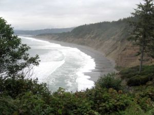
You reach the north end of Big Lagoon at ¾ mile. At the surge channel here, Big Lagoon drains into the Pacific after heavy winter rains. At extreme high tides, waves may dump salt water into the lagoon here as well. If you cannot pass the channel, you must return to the access point and follow the Alternate Route. When you can reach the barrier beach beyond the channel, you can follow the sandy shore all the way to Patrick's Point without interruption. (Be sure tides and weather are okay if you return this way!) The firmest footing is usually along the lagoon shore, but you may want to vary the long beach stroll by following the tideline or the crest of the barrier beach.
Around ⅞ mile you pass a large driftwood log atop the barrier beach, a good spot for a rest. As you continue south, the barrier beach broadens at 1⅛ miles, staying very broad until 1⅝ miles. Then the beach gradually narrows as Big Lagoon increases in width.
At 2⅛ miles you reach the first of several low spots in the beach where the breakers carry over the sand spit at extremely high tides. These low spots shouldn't be a problem since we warned you not to come out here at such tides. Continue past beach vegetation including dune tansy, sand verbena and beach strawberry. At 2⅞ miles a log atop the beach crest is posted "STATE PARK PROPERTY." Around 3 miles, Big Lagoon is more than a mile across. Several large driftwood logs provide seating and some shelter for a picnic and/or bird watching. This spot offers a good turnaround point for day hikers.
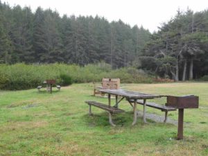
If you are continuing south on CCT, follow the sand spit another 1¼ miles. At 4¼ miles, you reach Big Lagoon County Park and the southern tip of Big Lagoon where restrooms, picnic tables, and a campground are a short walk east.
CCT continues along the sandy shore, with the previously watery views to the east replaced by golden cliffs that give the beach a sheltered feel. Cross the first of several seasonal creeks by 4½ miles where the cliffs rise as a low bluff. After a second seasonal stream, the cliffs rise 120 feet overhead.
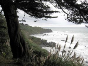
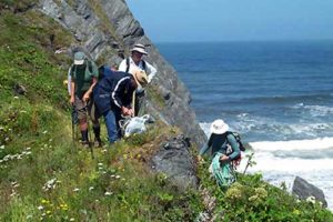
Follow the beach as it curves southwest toward Patrick's Point, the dramatic wooded promontory ahead. Small agates are often found along this Agate Beach. After two more small creeks around 5⅛ miles, the dun cliffs rise dramatically, reaching their highest point around 5⅝ miles where they soar almost vertically 400 feet above you in tilted sandstone strata. Continue past a steep gully. Around 5⅞ miles abundant lupine covers the cliff face, providing a spectacular color display from April through June. Pass the cliff's steepest face beyond 6 miles. Before 6⅛ miles you ford creek flowing out of a deep gully. In another 75 feet you want to leave the beach (impassable in 300 feet) and take the Agate Beach Trail that ascends steps beside a gully through dense coastal scrub. By 6½ miles it gains a narrow ridge and climbs through forest with views back along the sweeping beach you just traversed. Reach the trailhead at Agate Beach parking area at 6⅜ miles where restrooms and water are available. Pleasant Agate Beach Campground is nearby.
ALTERNATE ROUTE: When the point south of Dry Lagoon is impassable at medium to high tide, or when Big Lagoon breaches the barrier beach at its north end, you can walk east on the park access road to Highway 101, then walk the highway shoulder south to Big Lagoon County Park and return to the beach there.
SUGGESTED ROUND TRIPS & LOOPS: There are no loops here, but you can turn back anywhere along this beach walk. When Big Lagoon breaches the barrier beach at its north end, you can get to the long sandbar from Big Lagoon County Park at the lagoon's southwest corner.
Distance: 6⅜ miles (10.3 kilometers).
Open to: Hikers.
Surface: Beach, trail.
Access point: Dry Lagoon parking lot.
How to get there: Turn west off Highway 101 south of Orick at Milepost | 14.4 onto Dry Lagoon access road. Go one mile to end of road.
Other access: Big Lagoon County Park.
Difficulty: Easy
Elevation gain/loss: None for first 6⅛ miles, then 180 feet+ to southern end.
Cautions: Beach may be impassable at rocky point south of Dry Lagoon when tide is +2.0 feet or more. At north end of Big Lagoon when the lagoon breaches its barrier beach in winter and spring, beach route may not be passable. In these cases, see Alternate Route.
Further information: Humboldt Lagoons State Park (707) 488-2041, Big Lagoon County Park (707) 445-7652, Sue-meg State Park (707) 677-3570.
Facilities: Chemical toilets, picnic areas at Dry Lagoon State Park and Big Lagoon County Park. Full facilities at Patrick's Point.
Campgrounds: Dry Lagoon Environmental Camps are near access point. Big Lagoon County Park and Sue-meg State Park are en route.
Lodging: Motels are in Orick to the north or Trinidad to the south.

Interested in contributing to this project?
Register to add new photos and information, update existing results and share your trip reports.