
Usage Notes

Legend: For details on the icons and trail colors, please click the legend icon on the map above.

Layers: Other layers are available. See the California Coastal Commission and Coastal Conservancy Completed Sections layer for the official completed trail segments. (About progress on the trail completion project.)
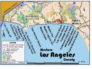
Los Angeles Section 2
Zuma Beach County Park to Dan Blocker State Beach
This hike features a spacious beach, expansive views from the top of Point Dume, sensitive natural habitat, and a walk along scenic sandy coves and tidal rocks at the base of cliffs removed from the development on the bluffs above. This hike is best done on an outgoing tide since the rocky areas, particularly between the south end of Dume Cove and Paradise Cove, flood at high tide.
From the south end of Zuma Beach County Park near the entrance station, head down the beach towards Point Dume rising in the distance. Before ⅜ mile you pass the mouth of Zuma Creek, then continue on Point Dume County Beach. It's also called Westward Beach and has Westward Beach Road running along the base of 100-foot bluffs. Westward Beach ends at the base of Point Dume, the point towering 203 feet above the shore.
At the base of the cliff north of the point at 1⅝ miles, a well-used trail goes through an opening in the fence and zigzags up the side of Point Dume. Where you intersect two trails on the ascent, take a right turn on each of them to reach an overlook at 2 miles. From this north overlook, you peer almost straight down into the ocean 200 feet below. It's a great vantage point for watching whales and some rock outcrops frequented by climbers as well. From the overlook the trail becomes sandy and informal, skirting the edge of the drop-off as it curves left around the point. Take one of several paths contouring to the point's south side. Around 2¼ miles you reach an overlook deck at the end of a boardwalk. This place is favored for seeing porpoises, gray whales and other marine mammals.
From here you look out on scenic Dume Cove and the Malibu coast to the south. Continue to the end of the boardwalk, passing cacti and various chaparral plants. Where a side trail forks left, you can take a short walk to the top of the hill for a striking 360° view. To reach Dume Cove, stay to the right at the end of the boardwalk. At 2½ miles take the trail and stairs, lined by a low chain link fence, that descends sharply to the beach.
Walk the quiet beach of Dume Cove at the base of steep cliffs to a secondary rocky point at 3 miles. The cove offers a pleasant place to wait if the point is flooded. When the point is passable, make your way along tidal rocks and picturesque sandy coves where you will find finely layered sedimentary rocks and good tidepooling.
At 4⅛ miles you reach Paradise Cove, a privately run beach with a small pier, restaurant, snack bar, picnic tables and restrooms. Beyond the pier, continue on narrow Escondido Beach, a favorite for divers that's lined with houses at the base of low bluffs and passable at all but the highest tides. Public access is via stairways, the first around 4⅞ miles (27200 Pacific Coast Highway). These stairways and others in following sections can best be identified by the fact that they are not marked with "NO TRESPASS" or "PRIVATE" signs. The first staircase is clearly visible as an imposing upright gray steel structure clinging to the cliffs. You'll find the second access around 5⅛ miles, just before where Escondido Creek empties into the ocean.
The CCT continues around rocky Latigo Point at 6¼ miles. About a mile beyond the point, two houses built on large boulders at the tideline block the beach. CCT exits the beach well before you reach the houses, at the public stairway at the south end of a row of white condominiums at 6⅝ miles. At the top of the stairs, turn right on Seagull Drive and walk to its end, then turn right again to follow the shoulder of Highway 1 along a chain link fence to pass the beach-hogging houses. Continue to the north end of Dan Blocker State Beach and the end of the section at 7½ miles. You'll find chemical toilets there. Across the highway a service station and an upscale restaurant sit adjacent to Corral Canyon Road.
SUGGESTED ROUND TRIPS AND LOOPS: From Zuma Beach explore Point Dume, Dume Cove and Paradise Cove and return for a fine 8¼ miles round trip. Or walk up to the highway from Paradise Cove where local bus #434, connecting Santa Monica and Trancas hourly, can carry you back to Zuma Beach.
On the inland side of Highway 1 near this section's end, Solstice Canyon offers a pleasant three-mile circuit along stream and through the hills. The park is the home of the Santa Monica Mountains Land Conservancy. The entrance to the park is .4 mile up Corral Canyon Road.
Distance: 7½ miles (12.1 kilometers).
Open to: Hikers.
Surface: Beach, trail, road shoulder.
Access point: Zuma Beach County Park.
How to get there: Zuma Beach is on Highway 1 about one mile west of Kanan-Dume Road and 8.7 miles west of Malibu town center.
Other access: Point Dume County Beach at the end of Westward Beach Road, Paradise Cove private parking lot ($15 fee), path to Escondido Beach in the 27200 block of Highway 1, steps to beach at Seacliff condos on Seagull Street.
Difficulty: Moderate
Elevation gain/loss: 200 feet+/200 feet-.
Cautions: Beaches close at sunset. Points and coves here are often flooded at high tide so it's best to time your hike with an outgoing tide.
Further information: Los Angeles County Lifeguard Service, Northern Section (310)457-9891, Paradise Cove (310)457-2511.
Facilities: Restrooms, water and picnic tables at Zuma Beach and Point Dume County Beach. Food, water and restrooms at Paradise Cove. Chemical toilets at Dan Blocker State Beach.
Campgrounds: Leo Carrillo State Beach has 127 sites and hot showers. Malibu Creek State Park campground, 5.5 miles inland on Malibu Creek Road, has 63 sites and hot showers. Malibu Beach RV Park south of Corral Canyon Road has 50 tent sites.
Lodging: You'll find motels and fancier digs along the Pacific Coast Highway.
Points of Interest

In the News
Interested in contributing to this project?
Register to add new photos and information, update existing results and share your trip reports.