
Usage Notes

Legend: For details on the icons and trail colors, please click the legend icon on the map above.

Layers: Other layers are available. See the California Coastal Commission and Coastal Conservancy Completed Sections layer for the official completed trail segments. (About progress on the trail completion project.)
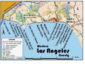
Los Angeles Section 1
Leo Carrillo State Beach to Zuma Beach County Park
Leo Carrillo was a popular movie, TV and Broadway actor, most notably as the sidekick of the Cisco Kid in that 1950s TV series. ("Oh Pancho!, Oh Cisco!" exclaimed the characters to each other to close every story.) Governor Earl Warren appointed Carrillo to the State Beaches and Parks Commission, and he played an instrumental role in public acquisition of much of the land between Malibu Lagoon and Point Mugu. Leo Carrillo State Beach includes almost two miles of coast plus rugged canyons and ridges inland.
The route, passing along some of the most beautiful beaches in southern California, can be negotiated in its entirety only at lower tides. If the tide is in, you must walk along the highway with a chance to visit beaches using several of the accesses mentioned in Other Access above. Beach hikers should keep in mind those same accesses to escape rising tides.
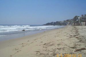
To begin this walk, park in the Leo Carrillo day-use parking lot across the highway from the beach. From the parking lot, find the concrete walkway that crosses under the highway alongside Arroyo Sequit Creek. During a rare winter storm, the walkway may be flooded which would mean carefully crossing the highway. The beach lies in the lee of scenic Sequit Point, a popular surfing and tidepooling spot. After turning south on the beach, you soon walk on cobblestones and sand. As the highway rises onto the bluff, the beach becomes secluded and highway sounds dwindle. At 1¼/4 miles a lifeguard station sits atop the bluff at what surfers call Point Zero, part of Nicholas Canyon County Beach. Continue around the point on the beach.
Two houses down the beach block access in the next mile at anything but low tide. You can exit the beach at Nicholas Canyon County Beach if necessary. If the tide is low enough to get by on the beach, you reach the El Pescador State Beach stairs at 2¾ miles, stairs at La Piedra State Beach at 3¼ miles, and El Matador State Beach stairs around 3⅝ miles. The three beaches together comprise R.H. Meyer Memorial State Beach. The rocky shoreline is passable at moderate to low tide.
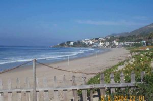
Continue on the beach to rocky Lechuza Point at 5⅛ miles. The rough tidal rocks require some scrambling and climbing to pass, safe only at lower tides. Beyond the point lies house-lined Trancas Beach. The high tide route exits the beach at the first rocky ledges before Lechuza Point. Take the short stairs up to the private road (open to public foot traffic) and turn right. Follow it up to Broad Beach Road and turn right before 5¼ miles. The closed but unlocked gate on the right side of the drive is for public access, although it is not clearly marked from inside. Descend to the beach beyond the point via a nearby informal path, or take the beach access stairs at 31300 Broad Beach Road.
Now on Trancas Beach, you head down coast (east) along the tideline at the base of low bluffs. After you pass the mouth of Trancas Canyon around 6⅜ miles, continue down the coast (southeast now) on Zuma Beach, one of the county's classic beaches. Watch for rip currents here. Walk the long sloping beach to its end at the far end of the Zuma County Beach parking lot adjacent to the entrance station and section's end at 8 miles.
ALTERNATE ROUTE: If the tide is blocking your way, the only alternatives are waiting it out or walking the shoulder of Pacific Coast Highway and Broad Beach Road. The series of public access ways means that you can explore each beach somewhat regardless of the tides. If you are inclined to drive between points, keep in mind that paying the parking fee at one state park allows you to park at any others on the same day.
SUGGESTED ROUND TRIPS AND LOOPS: From any of the access points you can explore varying lengths of coastline out and back. The Nicholas Flat Trail starts near the Leo Carrillo State Park entrance station. This superb trail climbs 4 miles into the beautiful and fragrant chaparral-covered hills, providing stunning views of the coast, ending in oak studded flats around a lovely pond.
Distance: 8 miles (12.9 kilometers).
Open to: Hikers.
Surface: Beach, streets, highway shoulder.
Access point: Leo Carrillo State Beach.
How to get there: Turn off Highway 14.3 miles north of the Malibu town center (about 25 miles north of Santa Monica) or 20 miles south of Oxnard. Turn into the clearly marked Leo Carrillo State Beach entrance road on the inland side of the highway just down the coast from the Mulholland Highway intersection and drive past the entrance kiosk to the day-use parking lot.
Other access: Nicholas Canyon County Beach, stairs to the beach at the 31100 & 31300 blocks of Broad Beach Road, parking for El Pescador, El Matador and La Piedra State Beaches, all signed on the highway.
Difficulty: Easy
Elevation gain/loss: Negligible.
Cautions: Rocky points and coves are flooded at high tide.
Further information: Leo Carrillo State Park (818)880-0350, Malibu Division, California State Parks (310)457-8140, Los Angeles County Lifeguard Service, Northern Section(310)457-9891.
Facilities: Toilets, water, picnic tables and parking at Leo Carrillo, El Pescador, La Piedra, El Matador State Beaches and Zuma Beach County Park.
Campgrounds: Leo Carrillo State Beach has 127 sites and hot showers.
Lodging: The Malibu coast has ample accommodations.

Interested in contributing to this project?
Register to add new photos and information, update existing results and share your trip reports.