
Usage Notes

Legend: For details on the icons and trail colors, please click the legend icon on the map above.

Layers: Other layers are available. See the California Coastal Commission and Coastal Conservancy Completed Sections layer for the official completed trail segments. (About progress on the trail completion project.)
Ventura Section 7
Sycamore Cove Beach, Point Mugu State Park to Leo Carrillo State Beach
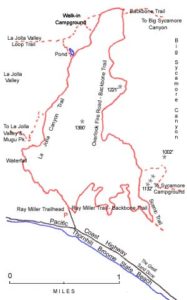
This last Ventura County section offers, like most of the Ventura walks, sharp contrasts in the condition of the coastline and the trail. The first part follows the road because of extensive riprap, while the second half follows relatively undisturbed scenic beaches.
From the Sycamore Cove Beach picnic area, walk up to the bike lane on Pacific Coast Highway and head south. The highway and the riprap protecting it obliterate most of the beach and tidal rocks. At medium to low tides you can scramble down the rocks to several pocket beaches marked by coastal access signs along the road, but for the most part, the bike lane or road shoulder offers the easiest alternative. Along the shoulder you round a point at ½ mile where the mountains tower on your left, then dip to the mouth of a small canyon. The highway dips close to sea level to cross another canyon at ⅞ mile, then passes Bass Rock at 1¼ miles. Contour east to the highway's intersection with Deer Creek Road around 1⅞ miles, where a stairway descends to a beach.
Contour east along the shoulder before dipping almost tO sea level around 2¼ miles. Climbing back to a narrow shelf at the base of the steep mountains, the highway crosses the mouth of another small canyon at 2½ miles, then contours above the surf. By 3⅛ miles you reach a row of houses on the low bluff. At low tide you can climb down the rocks to the exposed beach and walk in front of the houses and around a little point at the mouth of Little Sycamore Creek. Otherwise, stay on the road to cross Little Sycamore Creek bridge at 3⅝ miles.
Once across the bridge, turn right and follow the path out to the point and an informal parking area overlooking County Line Beach, also called Yerba Buena Beach. Descend to the beach, where surfers are usually catching rides on the point break, and walk the tideline east. As the beach narrows around 3¾ miles, you have to negotiate around riprap if the tide is low enough, otherwise return to the road until Staircase Beach.
If you can make it around the riprap, continue along the beach to a massive seawall protecting a condo project. If the beach in front of the seawall is flooded, take the stairs marked "NO TRESPASSING" up the seawall. The sign refers to the sandy flat in front of the building, not the stairs. You can walk on the seawall for 600 feet to the other end and another set of stairs leading down to the beach where you will find scenic natural bluffs. Note the remarkable contrast of these bluffs to the seawall you have just negotiated.
Around a rocky tidal point you reach public steps coming down to Staircase Beach beyond 4 miles. A small parking lot and a chemical toilet sit on the marine terrace above. Continue down the beach and watch for concrete steps coming down the bluff around 4¼ miles. These decorative steps, built by the owners of a house now gone, are worth a short detour to explore.
Beyond the steps you cross the Ventura/Los Angeles County line. At 4¾ miles you reach North Leo Carrillo State Beach and the beachside campground and parking lot. Walk to the far end of the beach beyond 5 miles.
At low tide you can stay on the beach and walk through an ocean cave under Sequit Point to reach the other side. Otherwise, walk up to the campground access road and follow it up to the flat top of Sequit Point. A wooden stairway from Sequit Point drops to a pocket beach and access to the cave. To continue over the point, take the path leading out to the point overlooking dramatic tidal rocks, then follow the trail around the point where fencing along the trail protects habitat restoration work. Near the second lifeguard station, take the paved path leading down to Sequit Creek and the beach at 5½ miles. Both the access road and a walkway under the highway next to the creek lead to the day-use parking and canyon campground at Leo Carrillo State Park. The usually dry creek is rarely impassable during storms, but if it is, carefully walk across the highway to the parking lot.
SUGGESTED ROUND TRIPS AND LOOPS: Walk the beach from either County Line Beach or Sequit Point out and back for a 4-mile round trip. The eroding cliffs above the attractive beach bloom profusely with giant coreopsis and other coastal plants in spring.
The Nicholas Flat Trail starts near the Leo Carrillo Campground entrance slation. The 8-mile round trip climbs through fragrant chaparral slopes to oak studded Nicholas Flats and a remarkably scenic pond.
Distance: 5½ miles (8.9 kilometers).
Open to: Hikers. Bicyclists on road.
Surface: Beach, road shoulder.
Access point: Sycamore Cove Beach.
How to get there: On Highway 1 about 4.5 miles north of the Los Angeles/Ventura County line, turn west into the Sycamore Cove Beach parking lot entrance opposite the campground on the inland side of the highway.
Other access: Anywhere along Highway 1.
Difficulty: Easy
Elevation gain/loss: 80 feet+/80 feet-.
Cautions:
Further information: Angeles District, California State Parks (818) 880-0350.
Facilities: Sycamore Cove Beach and Leo Carrillo State Beach have water, picnic tables and restrooms.
Campgrounds: Sycamore Canyon Campground east of the highway at Point Mug State Park has 54 sites. Leo Carrillo State Beach has 127 sites and hot showers.
Lodging: Oxnard, Port Hueneme and the Malibu coast to the south all have accommodations.


Interested in contributing to this project?
Register to add new photos and information, update existing results and share your trip reports.