
Usage Notes

Legend: For details on the icons and trail colors, please click the legend icon on the map above.

Layers: Other layers are available. See the California Coastal Commission and Coastal Conservancy Completed Sections layer for the official completed trail segments. (About progress on the trail completion project.)
Ventura Section 6A
Backbone Trail, Santa Monica Mountains National Recreation Area Ray Miller Trailhead to Will Rogers State Park
The 30-year-old dream of a Santa Monica Mountains Backbone Trail from the Griffith Observatory in Hollywood to the coast at Point Mugu failed to materialize in the early years. It seemed doomed to failure because of daunting private property holdings and development. Now after years of work by hundreds of dedicated people and several organizations, the Backbone Trail From Point Mugu to Will Rogers State Park nears completion. Much work remains including land acquisition for the last segment, installing signs, and providing water supplies for backcountry camps.
The completion of the Backbone Trail calls attention to a remarkable feat. It traverses some of the most rugged topography on the California coast as well as some of the most threatened by development. The area found new life by the creation of the Santa Monica Mountains National Recreation Area in 1978 and by the large State Parks pre-dating the Recreation Area. For more on the history and features of this remarkable area, read the feature article Santa Monica Mountains National Recreation Area.
At 66⅛ miles this alternate CCT High Route takes 29 miles longer than the coastal route and a whopping 8600 feet more elevation gain and loss, but it definitely has plenty to recommend it if you are game and hit.
A brief description of the Backbone Trail follows which we hope will whet your appetite to explore this wonderful region, walk the Backbone Trail, and become an advocate for the protection of the area and the completion and upkeep of the trail. The trail, rough and vague in parts, remains unsigned in some areas. In some cases the final route remains undetermined out of several possible existing or potential trails. Furthermore, long distances between trail camps with water discourage backpacking. Plans call for more camps. I you are through-hiking the CCT and choose this route over the much more populated coastal route, then a car pick up at day's end and a return ride back to the trailhead the next day permits comfortable day hiking. The sixteen road crossings along the route support this method.
To find out more about the status of the trail, check in at the Santa Monica Mountains National Recreation Area Visitor Center [or maps and updates. Maps showing the Backbone Trail and other trails in the region can be ordered from Tom Harrison Cartography, (415)456-7940, or Trails Illustrated, (800)962-1643. The Backbone Trail gets covered briefly in a book by Milt McAuley, the dean of Santa Monica Mountains trails and one of the major forces in creating the Backbone Trail. Order Hiking Trails of the Santa Monica Mountains, 6th edition, from Canyon Publishing Company, 8561 Eatough Avenue, Canoga Park CA 91305.
PART 1: Ray Miller Trailhead to Mishe Mokwa Trailhead.
DISTANCE: 16⅞ miles (27.2 kilometers).
The Backbone Trail starts in La Jolla Canyon at the Ray Miller Trailhead across Highway 1 [rom Thornhill Broome State Beach. This section through the wild and scenic Point Mugu State Park requires two-day backpack trip or a one day marathon hike because you meet no intersecting roads until 16⅞ miles at the East Gate Trailhead on Yerba Buena Road. Danielson Camp at 7½ miles has water and a restroom.
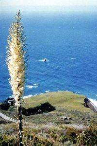
The equestrian route takes the Ray Miller Trail and intersects with the Sycamore Canyon Trail at 5⅞ 1 miles. The longer hiking route follows La Jolla Canyon into the lovely grassy flats of the upper canyon, the site of a significant Chumash village and the La Jolla Valley Walk-in Camp at 4 miles. The trail descends to the Sycamore Canyon Trail at 5⅞ miles (That popular tree-lined multi-use trail transects the mountains between Rancho Sierra Vista in Potrero Valley and Sycamore Canyon Campground at the ocean). You take Sycamore Canyon Trail to reach Danielson Camp with water, toilets and tables at 7½ miles. The trail then ascends the flank of scenic Boney Mountain. This waterless route climbs steadily for 7 miles from 400 feet to almost 3000 feet just below the highest point in the Santa Monica Mountains, Sandstone Peak (so called despite its volcanic origin) at 3111 feet. A short, steep spur trail climbs to the summit. The Backbone Trail route flanks the peak and descends to the Mishe Mokwa Trailhead at 16⅞ miles.
PART 2: East Gate Trailhead to Kanan Dume Road.
DISTANCE: 12⅛ miles (19.6 kilometers).
The first 5¼ miles of this route stays on the road. At press time, the National Park Service nears acquisition of the land needed to complete this last link in the Backbone Trail. Cautiously walk the shoulder of Little Sycamore Canyon Road, crossing the Ventura/Los Angeles County line at 2½ miles, then take Mulholland Highway to the Clarke Ranch Motorway Trailhead at 4¾ miles. Walk ½ mile on this trail to reach Encinal Canyon Road at 5¼ miles. Follow Encinal Canyon Road for 1¾ miles to Zuma Ridge Motorway at 7 miles. A new section of the Backbone Trail completed in early 1999 intersects the Zuma Ridge Motorway at 7¾ miles and reaches Kanan Dume Road at 12⅛ miles (29 miles from start).
PART 3: Kanan Dume Road to Tapia Park.
DISTANCE: 10¾ miles (17.3 kilometers).
You have a choice of two routes for the last half of this section. The official route continues more or less directly to Tapia Park while the more interesting and longer alternate route goes through Malibu Creek State Park, taking you through a bit of old Hollywood movie making history.
Take the Backbone Trail from the Kanan Dume parking lot. At ⅜ mile you cross the ridge over the road tunnel. At 2⅛ miles you reach Latigo Canyon Road and the Bulldog Motorway junction at 4⅜ miles. The Bulldog Motorway takes you on the Malibu Creek State Park alternate route. You'll pass the site of the movie and TV series M.A.S.H. and Century Ranch, the location for many westerns. You'll also see some great scenery as you pass lovely little Century Lake, walk among oak woodlands, then along Malibu Creek at the base of the striking Goat Buttes. You'll find a campground in Malibu Creek State Park. A connector trail from the campground joins the official route at Tapia Park.
The main route follows the Castro Crest, reaching a parking lot at Corral Canyon Road at 5¼ miles. You reach Peak 2049 at 7¾ miles, then descend 1500 feet into Malibu Canyon and Tapia Park at 10¾ miles (39¾ miles from start).
PART 4: Tapia Park to Dead Horse Trail parking lot on Topanga Canyon Blvd.
DISTANCE: 13⅜ miles ( 21.6 kilometers).
Dominated by Saddle Peak, this section climbs 2700 leet in 6⅜ miles before making the long descent down Hondo Canyon.
From the Tapia Park parking lot, the trail crosses Malibu Canyon Road at Piuma Road, parallels Cold Creek for ¼ mile, and then starts the long, steady climb up the flanks of Saddle Peak. It crosses Piuma Road at 1½ miles and continues winding up the mountain. You reach Saddle Peak at 6⅝ miles before starting down the other side. You come to the Stunt/Saddle Peak/Schueren Road junction at 7⅝ miles. Parallel the road for a short distance, then start down into Hondo Canyon. Cross Old Topanga Canyon Blvd. at 12¼ miles before crossing Topanga Canyon Road to the Dead Horse Trail parking lot off of Entrada Road at 13⅜ miles (53⅛ miles from start).
PART 5: Dead Horse Trail parking lot to Will Rogers State Historic Park.
DISTANCE: 11 miles (13 miles to Will Rogers State Beach) (17.7, 20.9 kilometers). Take the Dead Horse Trail from the parking lot off Entrada
Road above Topanga Canyon Blvd. and reach Trippit Ranch at 1⅛ miles. You'll find a Topanga State Park ranger station here with water, restrooms, picnic tables and a phone. Take the Musch Ranch Trail to reach Musch Camp at 2⅛ miles. This first-come first-served walk-in camp can be used by groups or as eight individual camps. You reach Eagle Junction at 3⅛ miles. Take either the North Loop via Eagle Rock or the South Loop via Eagle Springs. They come together at the Hub junction at 4½ miles. From the Hub, take the Rogers Trail to reach Will Rogers State Historic Park at 11 miles (64⅛ miles from start).
To complete the coast-to-coast connection, continue down the park entry road, turn right and follow Sunset Blvd., go left on Chatauqua Blvd. to its end, and carefully cross Highway 1 to Will Rogers State Beach. On the beach you meet the CCT's main route on L.A. Section 5, a sharp contrast to the chaparral-covered slopes of the last 66⅛ miles, to continue your journey to the Mexican border.
Distance: 64⅛ miles plus 2 miles to Will Rogers State Beach (103.2 + 3.2=106.4 kilometers).
Open to: Hikers and equestrians. Bicyclists on part.
Surface: Trail, road shoulder.
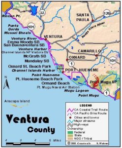
Access point: Ray Miller Trailhead.
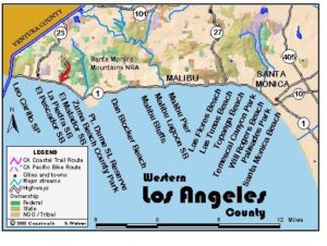
How to get there: Ray Miller Trailhead is on the inland side of Highway 1 across from Thornhill Broome State Beach, about 7 miles west of the Ventura/Los Angeles County line.
Other access: Circle X Ranch, Mishe Mokwa Trailhead, Kanan Dume Road/Newton Canyon Trailhead, Latigo Canyon Road Trailhead, Corral Canyon Road Trailhead, Malibu Creek State Park, Tapia Park, Piuma Trailhead, Dark Canyon Trailhead, Saddle Creek Road, Stunt Road/Saddle Peak Road/Schueren Road junction, Topanga State Park: Dead Horse Trailhead, Trippet Ranch.
Difficulty: Hard
Elevation gain/loss: 8800 feet+/8300 feet- for Backbone Trail. 8800 feet+/8800 feet including final two miles to beach.
Cautions: Carry ample water. Beware of rattlesnakes, ticks, poison oak, deer flies, harvester ants and possibly Africanized bees. In summer, the days are hot, black flies can be a nuisance, and most of the route is very dry. Extreme fire hazard in summer and fall. No smoking or fires along the Backbone Trail.
Further information: Santa Monica Mountains National Recreation Area Visitor Center, National Park Service, 40l West Hillcrest Drive, Thousand Oaks CA 91360 or call (805)370-2301. California State Parks, 1925 Las Virgines Road, Calabasas CA 91302 or call (818)880-0350.
Facilities: Water, tables, restrooms or chemical toilets at Ray Miller Trailhead, Danielson Camp, Malibu Creek State Park, Tapia Park, Trippet Ranch, Musch Camp, Will Rogers State Historic Park.
Campgrounds: Point Mugu State Park: Thornhill Broome State Beach Campground, La Jolla Group Camp, La Jolla Canyon Wilderness Camp, Danielson Multiuse Camp. National Recreation Area: Circle X Ranch Group Camp. Malibu Creek State Park Campground. Topanga State Park: Musch Camp. CAMPGROUNDS IN AREA: Point Mugu State Park: Sycamore Canyon Campground. Leo Carrillo State Beach Campground.
Lodging: You have a wide choice of hotels and inns located in various communities surrounding Santa Monica Mountains National Recreation Area. Santa Monica Hostel, downtown Santa Monica (310)393-9913.
Points of Interest

In the News
Interested in contributing to this project?
Register to add new photos and information, update existing results and share your trip reports.