
Usage Notes

Legend: For details on the icons and trail colors, please click the legend icon on the map above.

Layers: Other layers are available. See the California Coastal Commission and Coastal Conservancy Completed Sections layer for the official completed trail segments. (About progress on the trail completion project.)
Ventura Section 6
Point Mug Naval Air Station Entrance at Las Posas Road to Sycamore Cove Beach, Point Mugu State Park
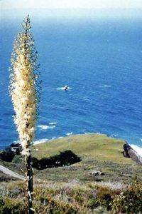
Less than a mile from Las Posas Road, the northern end of the scenic, rugged Santa Monica Mountains rises dramatically from the Oxnard Plain. Congress designated the state, federal, and county parks and beaches within the region as the Santa Monica Mountains National Recreation Area (SMMNRA), which reaches 70 miles down coast into Los Angeles County. The SMMNRA abounds in opportunities for hiking, biking, swimming, surfing, camping, sightseeing and even backpacking. The NRA brims with archeological sites, historic locations, and an ecosystem rich in plant and animal life. Read more about this great area in the adjacent feature article.
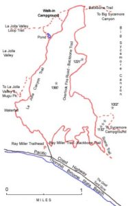
From Las Posas Road, walk down onto the wide bare strip of land between the highway onramp and the Navy base fence. Follow it ¼ mile to the Calleguas Creek bridge. Since the freeway ends at the north end of the bridge, cautiously cross the bridge and follow the wide shoulder of the Pacific Coast Highway. Beyond the fence inside the base and off limits to the public, extensive pickle weed marshes of Mugu Lagoon reach to the dunes. At 1½ miles you reach a wildlife viewing deck overlooking the marsh. A boardwalk is planned from the proposed Visitor Center at Las Posas Road to this deck. Continue along the wide shoulder. After passing a fence marking the southern limit of the closed area of the base, you overlook Mugu Beach at 2¾ miles with monolithic Mugu Rock looming at the other end. On the inland side of the highway, the Chumash Trail climbs over a pass to secluded La Jolla Valley. For the main CCT route, either continue on the road shoulder or drop down to the beach for the short stroll to Mugu Rock at 3 miles. The newer Pacific Coast Highway runs straight to pass through a huge man-made slash in Mugu Rock, cutting it off from its mother mountains.
For a short side trip, take the old roadbed angling around the seaward side of the rock to see why the highway was moved. In a few hundred yards the pavement of the old roadbed abruptly ends at a jagged edge, cut by an eroding ravine. On the big tidal rocks below, just before the broken off highway, you will find an impressive bed of fossil shells imbedded in the rock. Do not attempt to make your way around the upper end of the ravine on a narrow and dangerous volunteer trail. Return to the highway shoulder to continue south.
After passing through the man-made slash in the rock, the highway hugs the riprapped coast, so the only practical route stays on the highway shoulder to the beginning of Thornhill Broome Beach at 4⅞ miles. Across the highway you can see the mouth of La Jolla Canyon where the Backbone Trailhead marks the western end of the 64-mile Santa Monica Mountains Backbone Trail, a CCT High Route Alternate. For a description of that route, see Ventura Section 6A.
For the main CCT route, make your way down to the cobble and sand of Thornhill Broome Beach. Walk along the tideline past the campground. At the other end of the beach, climb up to the highway atop a low rise at 5⅞ miles. Walk the highway shoulder for only a short way, with the Great Sand Dune rising on the other side of the road, then descend from the highway to Sycamore Cove Beach with a State Park Ranger Station and picnic area. The section ends at the picnic area at 6¼ miles. Sycamore Canyon Campground, also the start of the Sycamore Canyon Trail, sits across the highway.
ALTERNATE ROUTE: The 64-mile-long Backbone Trail begins at La Jolla Canyon. When completed in a few years, it will provide a fine inland backpack trip along the rugged scenic ridges of the Santa Monica Mountains. See Ventura Section 6A for more on the Backbone Trail.
An alternate walk from Mugu Rock to Sycamore Canyon takes the Chumash Trail, which starts across the highway from the gunnery range, the La Jolla Loop Trial, and the Backbone Trail down to Sycamore Canyon Trail and back to the coast for a beautiful hike of about 8 miles.
SUGGESTED ROUND TRIPS AND LOOPS: The best thing any hiker dedicated to hiking and exploring can do is get a trail map of Santa Monica Mountains National Recreation Area which includes 15,000-acre Point Mugu State Park and many other public lands. We offer three trails here to explore the wild and scenic backcountry of Point Mugu State Park. All three trails intersect inland offering various loop possibilities. The Chumash Trail, across the highway from Mugu Beach, climbs steeply up a hillside on a trail used by the Chumash to get from their La Jolla Valley village down to the coast. The Ray Miller Trailhead at the La Jolla Canyon parking lot starts the Backbone Trail. See more about the Backbone Trail in Ventura Section 6A. The Big Sycamore Canyon Trail from the end of the Sycamore Canyon Campground explores a lovely canyon full of huge sycamore trees and lush vegetation.
Distance: 6¼ miles (10.1 kilometers).
Open to: Hikers. Bicyclists on road.
Surface: Beach, road shoulder.
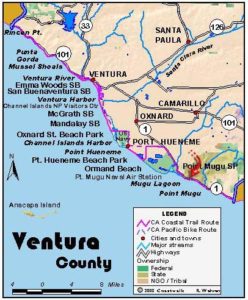
Access point: Las Posas Road at Highway (Pacific Coast Highway).
How to get there: Take Las Posas Road exit off Highway 1 and go south just a few hundred feet to the intersection of Las Posas Road and Naval Air Road.
Other access: Mugu Beach, Thornhill Broome Beach and along Highway 1.
Difficulty: Easy
Elevation gain/loss: 70 feet+/80 feet-.
Cautions: Watch for steep drop-offs at Mugu Rock. Use caution when walking highway shoulder.
Further information: Angeles District, California State Parks (818)880-0350.
Facilities: Thornhill Broome Beach and Sycamore Cove Beach have water, picnic tables and restrooms. While no facilities currently exist at Las Posas Road, a Santa Monica Mountains National Recreation Area Visitor Center is planned near this location in the future.
Campgrounds: Thornhill Broome State Beach with 88 primitive sites, Sycamore Canyon Campground with 54 sites and flush toilets, and La Jolla Group Camp are all at Point Mugu State Park.
Lodging: Port Hueneme and Oxnard have the nearest lodgings.
Points of Interest

In the News
Interested in contributing to this project?
Register to add new photos and information, update existing results and share your trip reports.