
Usage Notes

Legend: For details on the icons and trail colors, please click the legend icon on the map above.

Layers: Other layers are available. See the California Coastal Commission and Coastal Conservancy Completed Sections layer for the official completed trail segments. (About progress on the trail completion project.)
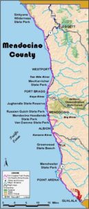
Mendocino Section 18
Moat Creek to Anchor Bay
Happily the Coastal Trail returns to the shoreline for the next two miles, first along remnants of another subdivision shut down by California voters supporting coastal access, then along a tidal beach with intriguing geologic anomalies. Plan your hike for a tide less than 2.0 feet, especially in winter when storm surf erodes Bowling Ball Beach sand. Lack of public access again forces the second portion of this CCT section along the highway.
Moat Creek Access, one of the hundreds of "Offer to Dedicate" (OTD) coastal access ways generated by 1972's successful voter initiative for the Coastal Protection Act, was the first OTD sponsored by a private group. Whiskey Shoals was a pre-Coastal Initiative subdivision north and south of Moat Creek. When California voters passed the initiative, the unfinished subdivision was shut down for not complying with the new laws, then acquired by the state when the developer defaulted on commitments to upgrade it. The Coastal Conservancy held the land for several years, then sold most of it to individuals, retaining a blufftop trail from Moat Creek to Ross Creek. The name Whiskey Shoals harks back to the days of Prohibition when rum runners used these fog-shrouded cliffs to land their illegal cargoes.
From the Moat Creek parking lot, the CCT now follows a new trail that heads east briefly from the top of the lot, then turns right (south) at a junction to climb to the blufftop. There the Coastal Trail veers right to circle the bluff's edge counterclockwise. At ⅛ mile you meet the top of the rough former trail, now abandoned, that climbed steeply from the mouth of Moat Creek. Stay on the path that follows the bluff edge down the coast, overlooking the magnificent golden striated cliffs that are a striking feature of the shoreline south of Point Arena. Heed the bright red and yellow signs that warn, " DANGER, BLUFFS CRUMBLE," and stay back from the edge. Around ½ mile the CCT veers left around a horseshoe cove.
By ⅝ mile you reach the south end of the Whiskey Shoals bluff. The CCT makes a dramatic, now well graded descent south toward Bowling Ball Beach, assisted by 33 steps on the steepest portion. At the bottom of the hill, the Coastal Trail veers left along the base of the grassy bluff to meet the Ross Creek Trail. Turn right and descend to the mouth of Ross Creek and tideline at ¾ mile. A small sea stack stands in the tidal zone beside the creek.
If you hike through here at a tide higher than 2.0 feet, especially in winter, you may not be able to get around the point ¼ mile south. In that case you must detour via the Alternate Route. Otherwise continue southeast along the beach from Ross Creek. The beach narrows and turns rocky around ⅞ mile, then broadens and becomes sandy as you approach the point at one mile. Around the point you can see the strata of the cliff face as they cross the tidal zone and run out to sea. These are the bowling lanes of Bowling Ball Beach, which runs southeast from the point.
Walk down Bowling Ball Beach, passing fissures in the striated cliffs beyond 1⅛ miles. You soon pass large circular disks of yellow sandstone protruding from the cliffs of gray sandstone. These weathered concretions, which look like giant chariot wheels, formed deep below the ocean and were deposited under great pressure in concentric layers.
Continue along the beach past another narrow point around 1¼ miles, then past spherical concretions lying loose in the tidal zone. These "bowling balls," which gave the beach its name, are best viewed at low tide.
CCT continues along the beach to the mouth of Galloway Creek at 1½ miles. The beach angles south to an impassable rocky point. Just beyond the creek the Coastal Trail veers left to climb a narrow path to the blufftop and a junction at 1⅝ miles. The left fork contours east to Highway 1. CCT takes the right fork along the bluff edge. Near the southern tip of the bluffs around 1¾ miles, your trail turns east to drop past an outhouse to a junction overlooking the sheltered sandy cove of Schooner Gulch Beach.
At the junction you can turn left to climb east along the verdant gulch to Highway 1 at 1⅞ miles, a route ¼ mile longer. You can instead turn right on a rougher route to reach the highway south of the narrow bridge over the gulch. To do that, descend 175 feet to the logjam at the mouth of the creek, then go south for 125 feet, cautiously crossing the logjam. At the first head-high rock, turn left on the path climbing the bluff. It's easy at first, then climbs steeply where trees lie across the trail. When you reach the highway at 1⅞ miles, turn right and walk the shoulder.
Before 2⅝ miles the Coastal Trail leaves the highway, heading out to the point north of Saunders Landing. You can walk the bluff edge or follow a paved road that ends on the point at 2¾ miles. Either way leads to headlands with sweeping vistas up the coast to Point Arena. Take a break to savor the view because CCT heads east around the south rim of the headland to return to the highway above a cove, the site of Saunders Landing.
Private property now forces the Coastal Trail to follow the highway shoulder south along a splendid coast of sparkling blue coves and wooded points. You have limited chances to see the beauty as you carefully walk the often narrow road shoulder through gulches and around numerous curves. The road walking isn't too bad until 3⅝ miles where you dip, twist and rise through Walker Gulch. Then contour along the highway across wooded headlands, crossing Morrison Gulch, then Slick Rock Creek at 4⅜ miles where white Sail Rock stands ¾ mile offshore.
Highway 1 straightens out past Steens Landing and across Signal Port Creek around 5¼ miles. Look south for views of the prominent peninsula called Havens Neck. From 5⅞ miles to 7¼ miles the highway winds and stays near the shore as it crosses Roseman Creek, Triplett Gulch and other small streams. Then a broad terrace occupied by private residences forces the road inland past Havens Neck around 7½ miles.
Continue along the winding highway shoulder with Fish Rocks towering 120 feet high offshore. Wind past several ocean -view lodgings and across Ferguson Gulch before 8¼ miles where the highway narrows and winds east into Fish Rock Gulch and past Anchor Bay Campground (lee for access to Fish Rock Beach) at 8½ miles. Follow the highway out ot the gulch and into the small town of Anchor Bay at 8⅝ miles where a store, restaurant and laundromat offer services. The final Mendocino County section of CCT starts here.
ALTERNATE ROUTE: When the tide is too high to round the point at one mile on Bowling Ball Beach, you must detour east at ¾ mile along the Ross Creek Trail and follow Highway 1 to the Schooner Gulch access.
SUGGESTED ROUND TRIPS & LOOPS: Whether you start from Moat Creek on the north or Schooner Gulch on the south, the beach and bluffs in between offer a pleasant and scenic round trip hike.
Distance: 8⅝ miles (13.9 kilometers).
Open to: Hikers. Bicyclists on road.
Surface: Trail, beach, highway shoulder.
Access point: Moat Creek Access.
How to get there: Turn west off Highway 1 south of Point Arena at Milepost 12.9 into dirt parking lot.
Other access: Ross Creek Trail, Schooner Gulch/Bowling Ball Beach, or anywhere south along Highway 1.
Difficulty: Easy
Elevation gain/loss: 650 feet+/600 feet-. Moat Creek to Schooner Gulch trailhead: 230 feet+/190 feet-.
Cautions: Use caution on trail along blufftop. Stay back from bluff's edge. Along highway, stay on road shoulder. Watch for traffic and use caution crossing highway.
Further information: Mendocino area State Parks (707)937-5804.
Facilities: None at start. Chemical toilets at Schooner Gulch. Restrooms, phone in Anchor Bay.
Campgrounds: Private Anchor Bay Campground is just before end of section.
Lodging: Four are along route just north of Anchor Bay, plus several in Point Arena.
Points of Interest

In the News
Interested in contributing to this project?
Register to add new photos and information, update existing results and share your trip reports.