
Usage Notes

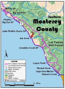
Legend: For details on the icons and trail colors, please click the legend icon on the map above.

Layers: Other layers are available. See the California Coastal Commission and Coastal Conservancy Completed Sections layer for the official completed trail segments. (About progress on the trail completion project.)
Monterey Section 11A (Alternate)
Ventana Inn to Lucia via Highway 1 Shoulder
The same rugged terrain that makes Big Sur a spectacular and unique place to visit also makes the choices for a route for the California Coastal Trail extremely limited. This Big Sur road walk offers a classic example of places where walking south on the highway's left shoulder facing traffic can be hazardous. Still, while the Big Sur high route in the previous three sections offers a far more pristine choice than this much driven highway route, the High Route is not advisable in winter or high summer or at any time by people without backpacking and wilderness experience.
The terrain and vistas you'll see on this section are truly wonderful and dramatic. Just be sure you don't take your mind off the often unrelenting, sometimes unsafe parade of vehicle traffic. Of course this is true whether you walk, cycle or drive this spectacular road. As you travel the route, you might ponder the arduous eighteen-year process involved in its construction, including nine years of pick-and-shovel prison-gang hard labor, tons of explosives, and years of innovative bridge design and construction.
Follow the highway shoulder as it climbs south to a summit before ⅛ mile, where you gain a breathtaking view of the coastline to the south. Then make a long, winding descent, passing several Big Sur landmarks. Before ¾ mile on the right, fabled Nepenthe offers food, drink and inspiring views from its perch high above the Pacific. Wind down past the Henry Miller Memorial Library on your left at one mile, then past the atmospheric Deetjen's Big Sur Inn astride Castro Canyon before 1½ miles. After almost a mile of gradual climbing, your winding asphalt ribbon resumes descending, passing a turnout with a coastal view before 2¾ miles. Another short ascent to 3⅛ miles gives way to another descent past two turnouts with grand views. The turnout near Milepost 41 looks down on an amazing sea lion haul-out on a rocky beach far below.
From 3⅞ miles, ascend, contour, then climb again to 4⅝ miles. Descend to cross the bridge over Torre Canyon at 4⅞ miles, ascend to 5¼ miles, then contour to 5¾ miles before making a longer descent to meet the Partington Cove Trail on your right just before Partington Creek at 6⅞ miles. The side trail on your right drops ¼ mile to a junction and outhouse. If you turn right at the junction, then take the left fork at the second junction in 100 feet, the trail ducks through a 120 foot-long tunnel to reach Partington Cove, a former doghole port and great spot to watch sea otters and sunsets. The right fork at the second junction leads to a tiny beach at the mouth of Partington Creek.
The Tan Bark Trail east of the highway climbs 1800 feet in 3¼ miles to the Tin House and grand views. (If the Ewoldsen Trail has been reopened to Tin House, you can take these upper trails for a 6⅜-mile alternate to walking the road, 4¼ miles longer than the road route.) Continuing along the highway shoulder, follow the road as it climbs to a vista point at 7¾ miles. The Fire Road Trail climbs north from there, reaching the Tin House in 2¼ miles. CCT descends gradually along the highway to 8¾ miles, then moderately to Julia Pfeiffer Burns State Park at 9 miles.
Consider a short side trip here of ¾ mile to see the McWay Creek waterfall as it plunges to surf line on a pristine beach. To find it, walk east on the park road for ⅛ mile where you'll find restrooms and a pay phone (a picnic area lies a bit farther up the canyon), then turn right and follow the Waterfall Trail under the highway to the viewpoint. CCT follows the highway south, descending gradually to cross the bridge over Anderson Canyon at 9½ miles. A short climb leads to a long contour above the rugged shoreline, then dips to cross the Burns Creek bridge at 10½ miles, where the Ventana Wilderness boundary is less than ½ mile upstream. Contour then climb gradually along the road's edge to cross the Buck Creek bridge at 11⅛ miles. The ascent continues briefly, then you descend to the Hot Springs Canyon bridge at 12⅛ miles.
Ascend along the highway, passing the turnoff to famed Esalen Institute on the ocean side, then climbing through a corner of the John Little State Reserve which preserves the coast around Lime Creek, which you cross on the bridge at 12⅝ miles. You soon descend along the narrow highway, dipping to the Dolan Creek bridge at 13¾ miles, then contouring to 14 miles, before descending again to 14⅝ miles to cross the Rat Creek bridge.
Follow Highway 1 as it climbs slightly to 15 miles, descends gradually to 16⅛ miles, then climbs briefly before dropping to the graceful double arch of the Big Creek bridge at 16⅞ miles. Big Creek's immense and stark landscape, also known as Devils Canyon, presents the biggest chasm Highway 1 has crossed since the Bixby Bridge. Much of the surrounding landscape is protected in the Landels-Big Creek Reserve managed by the University of California, with visitation only by occasional guided hikes. The Ventana Wilderness lies about 1½ miles upstream. Climb the highway shoulder down coast, passing a vista point around 17¾ miles, then continuing a gradual rise to 18⅝ miles. Before 18¼ miles watch on the left for the WPA-era Rigdon Drinking Fountain in a small canyon. There a massive picnic table offers a welcome rest for the weary foot traveler, but alas no working fountain. Nearby stone steps lead to three gnarled old redwoods and a trail that dips under a fence to the creek, the fountain perhaps shrouded in the dense undergrowth.
Descend the twisting highway through the steep, rocky terrain around Gamboa Point, dropping to the Vicente Creek bridge at 19⅜ miles. The highway climbs to 20⅜ miles, then dips to 21⅛ miles where it rounds Lopez Point, only to ascend steeply to 21⅝ miles. Descend briefly to pass the highway sign for Lucia at 22 miles, then contour to section's end at the Lucia Cafe & Cabins at 22¼ miles.
ALTERNATE ROUTE: See Sections 11, 12 and 13 for preferred high route, a strenuous and seasonal alternative to the highway shoulder walk.
SUGGESTED ROUND TRIPS & LOOPS: Take the pleasant ⅝-mile round trip hike to Partington Cove. Explore the upland trails of Julia Pfeiffer Burns State Park. You can make a pleasant shuttle or loop by taking the Tan Bark Trail from Partington Cove to the Tin House, then descending the Fire Road Trail for a 5⅝-mile hike and a .8 mile car shuttle. Or descend from Tin House on the Ewoldsen Trail for a 6⅜-mile hike with a 2.1 mile shuttle.
Distance: 22¼ miles (35.8 kilometers).
Open to: Hikers, bicyclists.
Surface: Highway shoulder.
Access point: Ventana Inn turnoff on Highway 1.
How to get there: On Highway 1 only .6 mile south of the Big Sur post office, the turnoff to Ventana Inn is east of the highway at Milepost 44.3. Section starts there, with day-use parking at Ventana Inn (lot .15 miles up inn road) or dirt turnouts north or south along highway.
Other access: Anywhere along route.
Difficulty: Moderate
Elevation gain/loss: 1430 feet+/2050 feet-.
Cautions: Narrow shoulders! Use extreme caution if you road walk this narrow, winding and busy section of highway. Wear bright clothes, walk in a group and walk single file. Midweek is best time to do this road walk.
Further information: None.
Facilities: Julia Pfeiffer Burns State Park along the route has restrooms, water, phone and picnic tables.
Campgrounds: Ventana Campground is near start or try Pfeiffer-Big Sur State Park not far to the north. Julia Pfeiffer Burns State Park en route has two walk-in/environmental camps, but reservations can only be made in advance, 1-800-444-7275.
Lodging: The local inns, Ventana and Post Ranch, both start around $200/night. For more affordable rates, look south to historic Deetjen's Big Sur Inn and Lucia or north to Big Sur Lodge, Ripplewood Resort, Big Sur Cabins or Glen Oaks Motel.
Points of Interest

In the News
Interested in contributing to this project?
Register to add new photos and information, update existing results and share your trip reports.