
Usage Notes

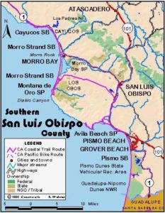
Legend: For details on the icons and trail colors, please click the legend icon on the map above.

Layers: Other layers are available. See the California Coastal Commission and Coastal Conservancy Completed Sections layer for the official completed trail segments. (About progress on the trail completion project.)
San Luis Obispo Section 10
Pecho Coast Trail: Port San Luis to Rattlesnake Canyon
The Pecho Coast Trail was opened for docent led tours in 1991, ending Pacific Gas & Electric Company's exclusive use of this pristine twelve miles of coast. The California Coastal Commission negotiated the public access trail with PG&E as a concession for a 1983 construction project at Diablo Canyon. PG&E spent $300,000 to open the trail, working with the Nature Conservancy and local conservation groups to organize and train docents to lead the hikes that occur here, usually held on Wednesdays and Saturdays. The California Conservation Corps constructed the well-engineered, occasionally steep trail. While the Nature Conservancy is no longer involved, you'll find the docents well-trained and knowledgeable guides, with each docent bringing their own particular knowledge and expertise to the hikes. Call in advance to reserve space on the popular hikes.
Meet your guides and fellow hikers in the wide parking area on the opposite side of the road from the PG&E gate. Your guided hike crosses the road to the security gate, then climbs stairs on the left, passing through a locked gate. From the top of the stairs, your group follows a trail through coastal sage scrub.
Switchback twice around ⅛ mile and climb west to a gravel road built in the 1950s for lighthouse access.
Follow the road south, climbing gradually with views on your left over the vast expanse of San Luis Bay. A Chumash village site, where habitation has been traced back 9500 years, lies below the road. Around ⅜ mile an Indian tobacco bush grows on the right side of the road. Climb moderately past native rye grass. Around ½ mile a road cut on your right has gray-green and black layers of serpentine rock. It's an exposed fault with sedimentary rocks underlying it. Continue a moderate ascent overlooking San Luis Bay. When it's clear you can see Point Sal at the southern end of the bay.
Beyond ⅝ mile a sign welcomes you to the Pecho Coast Trail. From here your hike descends steeply on rough steps, dropping toward the Harford Pier south of your starting point. The path switchbacks to the right around ¾ mile and descends gradually, soon dipping under shady coast live oaks where a plaque commemorates Pat Stebbins, the Coastal Commission staffer who strongly advocated for broad public access to the California coast. Here you meet part of the historic trail between the 1888 Point San Luis lighthouse and the harbor. The children of the lighthouse keepers once had to walk this trail to get to and from school.
CCT follows the original trail south, climbing across a small seasonal stream where Mexican or hummingbird sage grows. Descend briefly from one mile then contour, all with grand views of the San Luis Bay coast. A short steep ascent around 1¼ miles leads to more vista-rich contouring. Around 1⅜ miles you descend steep steps across a recent slide, then contour along the bottom of a steep rocky slope above Smith Island, approaching Point San Luis. As you descend to the point at 1½ miles, you can see Whalers Island right below, now part of a breakwater extending from the tip of the point.
After reaching the southern face of Point San Luis, CCT joins a semi-paved road, descending it toward the lighthouse. When the lighthouse was built in 1888, Port Harford was a thriving whaling community, producing abundant whale oil to fuel the light. Several of the whaling town's buildings stood along this road. The whaling station closed just after 1900.
The light house finally comes into view around 1¾ miles. Walk the pavement past the caretakers' house, the signal building and the current automated light to stand before the historic lighthouse at 1⅞ miles. Picnic tables and a toilet nearby provide a respite. When it's reasonably clear here, you can see beyond Point Sal to Point Arguello 40 miles south on the Vandenberg coast. The shorter guided hikes return from the lighthouse.
If you're participating in a Rattlesnake Canyon hike, beyond the lighthouse your group climbs briefly, passes through a gate, then follows an old ranch road as it contours northwest up the Pecho coast. After crossing a gulch around 2½ miles, your rough road descends then contours across a sloping grassy marine terrace above the rocky shore. Chaparral draped ridges tower on your right. Beyond 2¾ miles the eroded ranch road descends toward the shore. Before 3 miles you round a point at the base of a ridge, gaining a broad vista of the Pecho coast to the north. Pass through a ranch gate with Chumash shell midden nearby before 3¼ miles, then contour across a broadening gentle marine terrace through lush grasslands. Around 3⅜ miles the track becomes vague but you head for another ranch gate near the bluff's edge.
After passing through the gate, your trailless trek follows the left side of a barbed wire fence up a gentle incline. Soon you follow the rim of Rattlesnake Canyon. As you ascend, the canyon on your left becomes deeper. It's filled with colorful, wildly shaped coast live oaks. Dip through a side canyon at 3⅝ miles and come to a grassy picnic area with long-focus vistas up the Pecho coast including 1414-foot Green Peak to the northwest. The nuclear plant lies 1½ miles west of the peak's summit. You'll find an open-air toilet with a view about 300 feet east of the picnic spot.
The guided hike returns by heading east, then southeast along the top of fence, rejoining your outward route above the last gate. Enjoy the views down the coast as you return to the trailhead. When the guided hike ends, returning tO PG&E's south gate, through hikers will need to walk east on the shoulder of Avila Beach Drive for 2¼ miles to Cave Landing Road, then turn right and climb ½ mile to the start of SLO Section 11.
Distance: 3¾ miles (7½ miles round trip, add 2¾ miles if you need to walk to start of Section 11) (6.0, 12.1, 4.4 kilometers).
Open to: Guided hikes by prior reservation only.
Surface: Trail, paved road.
Access point: Port San Luis.
How to get there: From the north, exit Highway 101 south of San Luis Obispo onto San Luis Bay Road. Turn right and go 1.4 miles to road's end, then turn right on Avila Beach Drive and go 3 miles to PG&E's south gate. From the south, exit Highway 101 north of Shell Beach onto Avila Beach Drive. Turn left and drive 4.3 miles to PG&E's south gate. Park on road shoulder opposite gate.
Other access: None.
Difficulty: Moderate
Elevation gain/loss: 830 feet+/830 feet- round trip to trail's end. 650 feet+/650 feet- to lighthouse.
Cautions: Pecho Coast Trail is only open for scheduled docent led hikes. You must make a reservation in advance.
Further information: PG&E Pecho Coast Trail information (805)541-8735.
Facilities: Chemical toilets at start, lighthouse and Rattlesnake Canyon.
Campgrounds: Avila Beach area has a private campground, the Avila Hot Springs Spa & RV Resort. Pismo State Beach at end of Section 11 has 103 units.
Lodging: Many choices in San Luis Obispo, a few in Avila Beach. Hostel Obispo (805)544-4678 is in San Luis Obispo.


Interested in contributing to this project?
Register to add new photos and information, update existing results and share your trip reports.