
Usage Notes

Legend: For details on the icons and trail colors, please click the legend icon on the map above.

Layers: Other layers are available. See the California Coastal Commission and Coastal Conservancy Completed Sections layer for the official completed trail segments. (About progress on the trail completion project.)
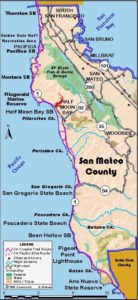
San Mateo Section 3
Pacifica State Beach to Montara State Beach
This unforgettable hike starts at the beach, climbs over the flank of wild and undeveloped Montara Mountain, runs through McNee Ranch State Park, and drops down to another beach. You walk an historic road through the site of a long-term controversy over plans to build a freeway over the mountain.
In 1769 the Gaspar de Portola expedition camped beside an Ohlone village by the mouth of San Pedro Creek where this section begins. From there they climbed east up Sweeney Ridge and discovered San Francisco Bay. See the feature article.
From the south end of Pacifica State Beach, walk east across Highway 1 at Linda Mar Boulevard and follow the highway south. Cross the bridge over San Pedro Creek before ¼ mile and turn left on San Pedro Terrace Road. You can walk on the road or follow the path north of the road along the channeled brushy creek, returning to the road before Peralta Road. Go right on Peralta for a block, left on Rosita Road to Adobe Drive, where you go right to narrow Higgins Way. Walk east on Higgins to its end where a gate blocks the road at 1¼ miles. Behind the gate follow the historic Old San Pedro Mountain Road. This fire road climbs through steep and rugged terrain, winding through a rich coastal scrub plant community full of wildlife, including the endangered peregrine falcon and San Bruno elfin butterfly.
You reach the top at 3¼ miles after a 900-loot ascent. The fire road crosses a saddle between Montara Mountain and San Pedro Mountain to the west. Take a few minutes to absorb the breathtaking views north and south. Imagine that the California Department of Transportation planned an 80-foot wide reroute of Highway 1 climbing the ridge and passing over this saddle. Thanks to the protests of San Mateo County residents, this plan was withdrawn, and twin tunnels through the mountain are being built. When it is closed to vehicles, the old highway will provide a dramatic route for the Coastal Trail.
From the saddle, CCT descends to Montara Beach. Follow the main fire road, ignoring any side trails as it snakes its way down a series of switchbacks into McNee Ranch State Park. At the bottom pass the old McNee farm house and follow the dirt road out to the highway at 6 miles. Be especially careful crossing the highway since the traffic descending from Devil's Slide goes very fast here. Walk south ⅛ mile on the shoulder to a parking area and take the stairway down to the beach. Walk this quiet beach popular for fishing, surfing and picnicking to its south end at 6⅝ miles where this section ends. A parking area and restrooms are on the bluff beside Highway 1.
SUGGESTED ROUND TRIPS & LOOPS: From the north end of Montara Beach, walk into McNee State Park and up the Old San Pedro Mountain Road to the ridge and back, 5¾ miles round trip.
Distance: 6⅝ miles (10.7 kilometers).
Open to: Hikers. Bicyclists on part.
Surface: Trail, road shoulder, beach.
Access point: Pacifica State Beach.
How to get there: Turn west off Highway in Pacifica at Linda Mar Blvd. into Pacifica State Beach parking lot .
Other access: McNee Ranch State Park, Montara Beach.
Difficulty: Moderate
Elevation gain/loss: 900 feet +/900 feet-.
Cautions: Steep climb over Montara Mountain. Watch for bicyclists descending San Pedro Mountain Road.
Further information: Bay Area District, California State Parks (415)330-6300.
Facilities: Water, restrooms, picnic tables at both ends.
Campgrounds: Pacific Park RV Resort on previous section.
Lodging: Pacifica has several motels. Montara Lighthouse Hostel (650) 728-7177.

Interested in contributing to this project?
Register to add new photos and information, update existing results and share your trip reports.